2,566 ft
Distance
6 ft
Climb
-315 ft
Descent
00:14:58
Avg time
K Hole Details
-
Activities
- Mountain Bike
-
Riding AreaWestern Hills
Wellington -
AKA98DH
-
Difficulty Rating
-
Voted DifficultyDouble Black Diamond (2 votes)
-
Trail TypeSingletrack
-
Bike TypeDH
-
DirectionDownhill OnlyPopular direction shown
-
Physical RatingExtreme
-
Dogs AllowedYes
-
TTFs on TrailDrop, Jump, Gap Jump, Rock Face
-
Global Ranking#38279 in Mountain Biking
-
Local Popularity45 in Mountain Biking
-
Land Manager
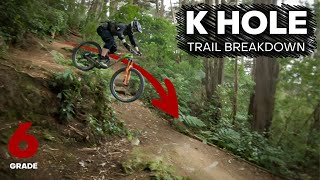
Formally known as 98DH.
Shuttle friendly DH track. Now ends with a gap jump since the old track was rerouted.
Access Info
Access top of trail by the playground by 99 Montgomery Ave, Karori. Ride along Skyline track fro approx 400 m then entrace is on the left. Entrance is a short climb to a wooden platform.
Traditionally Indigenous Territory
More Stats for K Hole mountain bike trail trail
-
Altitude change-309 ft
-
Altitude min594 ft
-
Altitude max903 ft
-
Altitude start903 ft
-
Altitude end594 ft
-
Grade-12.1%
-
Grade max-45.3%
-
Grade min8.2%
-
Distance climb75 ft
-
Distance down2,392 ft
-
Distance flat98 ft
-
Avg time00:14:58
-
Avg reverse time00:16:03
- view trail stats
close
Trail Conditions
- Unknown
- Snow Groomed
- Snow Packed
- Snow Covered
- Snow Cover Inadequate
- Freeze/thaw Cycle
- Icy
- Prevalent Mud
- Wet
- Variable
- Ideal
- Dry
- Very Dry
Trail Flow (Ridden Direction)
Trailforks scans users ridelogs to determine the most popular direction each trail is ridden. A good flowing trail network will have most trails flowing in a single direction according to their intension.
The colour categories are based on what percentage of riders are riding a trail in its intended direction.
- > 96%
- > 90%
- > 80%
- > 70%
- > 50%
- < 50%
- bi-directional trail
- no data
Trail Last Ridden
Trailforks scans ridelogs to determine the last time a trail was ridden.
- < 2 days
- < 1 week
- < 2 weeks
- < 1 month
- < 6 months
- > 6 months
Trail Ridden Direction
The intended direction a trail should be ridden.
- Downhill Only
- Downhill Primary
- Both Directions
- Uphill Primary
- Uphill Only
- One Direction
Contribute Details
Colors indicate trail is missing specified detail.
- Description
- Photos
- Description & Photos
- Videos
Trail Popularity ?
Trailforks scans ridelogs to determine which trails are ridden the most in the last 9 months.
Trails are compared with nearby trails in the same city region with a possible 25 colour shades.
Think of this as a heatmap, more rides = more kinetic energy = warmer colors.
- most popular
- popular
- less popular
- not popular
ATV/ORV/OHV Filter
Max Vehicle Width
inches
Radar Time
x
Activity Recordings
Trailforks users anonymized public ridelogs from the past 6 months.
- mountain biking recent
- mountain biking (>6 month)
- hiking (1 year)
- moto (1 year)
Activity Recordings
Trailforks users anonymized public skilogs from the past 12 months.
- Downhill Ski
- Backcountry Ski
- Nordic Ski
Jump Magnitude Heatmap
Heatmap of where riders jump on trails. Zoom in to see individual jumps, click circles to view jump details.
Trails Deemphasized
Trails are shown in grey.
Only show trails with NO bikes.
Directions to k-hole trailhead
(-41.279910, 174.724610)
update trails status or condition
K Hole Trail Reports
view all reports »
Recent Ridelog Activity on Trail
Past Week
- 0 rides
6 Months
- 49 rides
- 12 miles avg distance
All
- 259 rides
Photos
more »
Videos
more »
youtuber

7:46 |
125 |
Jan 31, 2022 , Wellington
Nearby Trails
- Percy Dyett 725 ft
- Wahine 2,444 ft
- K2 2,444 ft
- Khouri 3,330 ft
- Skyline 3,392 ft
- embed K Hole trail on your website
- By WMTBC & contributors
- #22468 - 10,868 views
- subscribe
- login to download gpx or kml files.
Open trail in mobile app