1,381 ft
Distance
-131 ft
Descent
00:02:47
Avg time

Kotten Details

  • Activities
    • Mountain Bike
    • Hike
    • Trail Running
  • Riding Area
    Änggårdsbergen
    Göteborg
  • AKA
    Enjoy
  • Difficulty Rating
  • Voted Difficulty
    Blue (1 vote)
  • Trail Type
    Singletrack
  • Bike Type
    AM
  • Direction
    Downhill Primary
    Popular direction shown
  • Dogs Allowed
    Yes
  • Global Ranking
    #7877 in Mountain Biking [+]
    • #33234 in Trail Running
    • #86294 in Hiking
  • Local Popularity
    100 in Mountain Biking [+]
    • 50 in Trail Running
    • 80 in Hiking
  • Year Opened
    2015

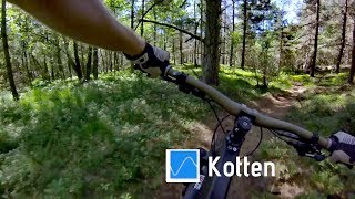
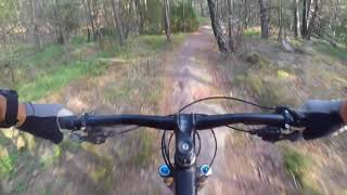
Snabb och flowig stig med några få berms och hög medelhastighet. Slutar med en halvknixig stenkista efter nittio grader höger ner mot ridstigen.

Heter Kotten eftersom den ofta är överfull med just ..kottar när ingen cyklat den på ett tag.

Access Info

Sväng av höger från sandiga innan den börjar gå utför.

Local Trail Association
More Stats for Kotten mountain bike trail trail
  • Altitude change
    -132 ft
  • Altitude min
    205 ft
  • Altitude max
    337 ft
  • Altitude start
    337 ft
  • Altitude end
    207 ft
  • Grade
    -9.5%
  • Grade max
    -17.4%
  • Grade min
    -2.1%
  • Distance down
    1,381 ft
  • Avg time
    00:02:47
  • Avg reverse time
    00:08:08
  • view trail stats
Status:
on Apr 30, 2022
Dry
Avg: 4.4 (10 votes)
Your vote: 0

view (3,520)
close
3D
Trail Conditions
  • Unknown
  • Snow Groomed
  • Snow Packed
  • Snow Covered
  • Snow Cover Inadequate
  • Freeze/thaw Cycle
  • Icy
  • Prevalent Mud
  • Wet
  • Variable
  • Ideal
  • Dry
  • Very Dry
Trail Flow (Ridden Direction)
Trailforks scans users ridelogs to determine the most popular direction each trail is ridden. A good flowing trail network will have most trails flowing in a single direction according to their intension.
The colour categories are based on what percentage of riders are riding a trail in its intended direction.
  • > 96%
  • > 90%
  • > 80%
  • > 70%
  • > 50%
  • < 50%
  • bi-directional trail
  • no data
Trail Last Ridden
Trailforks scans ridelogs to determine the last time a trail was ridden.
  • < 2 days
  • < 1 week
  • < 2 weeks
  • < 1 month
  • < 6 months
  • > 6 months
Trail Ridden Direction
The intended direction a trail should be ridden.
  • Downhill Only
  • Downhill Primary
  • Both Directions
  • Uphill Primary
  • Uphill Only
  • One Direction
Contribute Details
Colors indicate trail is missing specified detail.
  • Description
  • Photos
  • Description & Photos
  • Videos
Trail Popularity ?
Trailforks scans ridelogs to determine which trails are ridden the most in the last 9 months. Trails are compared with nearby trails in the same city region with a possible 25 colour shades. Think of this as a heatmap, more rides = more kinetic energy = warmer colors.
  • most popular
  • popular
  • less popular
  • not popular
ATV/ORV/OHV Filter
Max Vehicle Width
inches

Radar Time
x Activity Recordings
Trailforks users anonymized public ridelogs from the past 6 months.
  • mountain biking recent
  • mountain biking (>6 month)
  • hiking (1 year)
  • moto (1 year)
Activity Recordings
Trailforks users anonymized public skilogs from the past 12 months.
  • Downhill Ski
  • Backcountry Ski
  • Nordic Ski
  • Snowmobile
Jump Magnitude Heatmap
Heatmap of where riders jump on trails. Zoom in to see individual jumps, click circles to view jump details.
Trails Deemphasized
Trails are shown in grey.
disable
Only show trails with NO bikes.
enable

Save the current map location and zoom level as your default home location whenever this page is loaded.

Save
      Directions to kotten trailhead (57.665000, 11.962550)

      Recent Ridelog Activity on Trail

      Past Week
      • 6 rides
      • 5 miles avg distance
      6 Months
      • 132 rides
      • 9 miles avg distance
      All
      • 3,117 rides
      • Last: Mar 27, 2023

      Photos

      more »
      18 |
      Aug 21, 2022 @ 2:50am
      Aug 21, 2022
      39 |
      Sep 16, 2021 @ 10:11am
      Sep 16, 2021
      29 |
      Sep 16, 2021 @ 9:56am
      Sep 16, 2021
      48 |
      Sep 16, 2021 @ 9:56am
      Sep 16, 2021

      Routes with this trail

      more »
      titledistance
      Änggårdsbergen Blue Mania5 miles
      Änggårdsbergens Ryggar8 miles
      Änggårdsbergen Deluxe13 miles
      Hard XC10 miles

      Reviews / Comments

      No reviews yet, be the first to write a review or ask a question.
      Use trail reports to comment on trail conditions.


      Login or Sign Up to Comment

      Videos

      more »
      Änggårdsbergen - Kotten
      1:11 | 447 | Jun 11, 2018 , Göteborg
      Änggårdsbergen, Kotten
      1:06 | 304 | Sep 4, 2018 , Göteborg
      My PR on the trail 'Enjoy'
      1:18 | 182 | Feb 13, 2017 , Göteborg
      Swedish loam
      1:25 | 709 | Nov 30, 2016 , Göteborg
      • subscribe
      • flag
      • login to download gpx or kml files.