7.2 miles
Distance
511 ft
Climb
-534 ft
Descent
00:57:40
Avg time
Supporters, Builders, Maintainers & Land Managers of Landmine Loop Trail
  • BLM
    BLM
    Land Manager

Landmine Loop Details

  • Activities
    • Mountain Bike
    • Hike
    • Trail Running
  • Riding Area
    Cottonwood Valley
    Las Vegas, Nevada
  • Difficulty Rating
  • Voted Difficulty
    Blue (1 vote)
  • Trail Type
    Singletrack
  • Direction
    Both Directions
  • Climb Difficulty
    Blue
  • Physical Rating
    Moderate
  • Dogs Allowed
    Yes
  • Global Ranking
    #2811 in Mountain Biking [+]
    • #6191 in Trail Running
    • #16774 in Hiking
  • Local Popularity
    90 in Mountain Biking [+]
    • 100 in Trail Running
    • 80 in Hiking

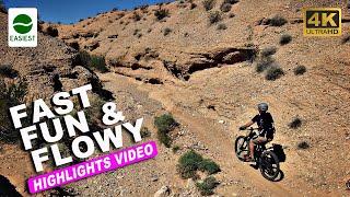
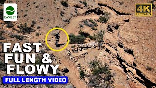
This is the main access trail to the rest of Blue Diamond/Cottonwood. It's a pretty decent climb and a fun and challenging downhill when you're headed back in. Don't forget to look up and look around.. you can get some great views of the red hills of the canyon. This trail is mainly dirt and rock but it can get technical at times. You can split off this trail at any time to find some more fun dirt or use it to do laps around the mountain

Local Trail Association
More Stats for Landmine Loop mountain bike trail trail
  • Altitude change
    -24 ft
  • Altitude min
    3,395 ft
  • Altitude max
    3,736 ft
  • Altitude start
    3,419 ft
  • Altitude end
    3,396 ft
  • Grade
    -0.1%
  • Grade max
    -21.2%
  • Grade min
    33%
  • Distance climb
    3 miles
  • Distance down
    4 miles
  • Distance flat
    3,107 ft
  • Avg time
    00:57:40
  • Avg reverse time
    01:21:08
  • view trail stats
Status:
on Mar 23, 2023
Ideal
Avg: 4.3 (31 votes)
Your vote: 0

view (2,235)
close
3D
Trail Conditions
  • Unknown
  • Snow Groomed
  • Snow Packed
  • Snow Covered
  • Snow Cover Inadequate
  • Freeze/thaw Cycle
  • Icy
  • Prevalent Mud
  • Wet
  • Variable
  • Ideal
  • Dry
  • Very Dry
Trail Flow (Ridden Direction)
Trailforks scans users ridelogs to determine the most popular direction each trail is ridden. A good flowing trail network will have most trails flowing in a single direction according to their intension.
The colour categories are based on what percentage of riders are riding a trail in its intended direction.
  • > 96%
  • > 90%
  • > 80%
  • > 70%
  • > 50%
  • < 50%
  • bi-directional trail
  • no data
Trail Last Ridden
Trailforks scans ridelogs to determine the last time a trail was ridden.
  • < 2 days
  • < 1 week
  • < 2 weeks
  • < 1 month
  • < 6 months
  • > 6 months
Trail Ridden Direction
The intended direction a trail should be ridden.
  • Downhill Only
  • Downhill Primary
  • Both Directions
  • Uphill Primary
  • Uphill Only
  • One Direction
Contribute Details
Colors indicate trail is missing specified detail.
  • Description
  • Photos
  • Description & Photos
  • Videos
Trail Popularity ?
Trailforks scans ridelogs to determine which trails are ridden the most in the last 9 months. Trails are compared with nearby trails in the same city region with a possible 25 colour shades. Think of this as a heatmap, more rides = more kinetic energy = warmer colors.
  • most popular
  • popular
  • less popular
  • not popular
ATV/ORV/OHV Filter
Max Vehicle Width
inches

Radar Time
x Activity Recordings
Trailforks users anonymized public ridelogs from the past 6 months.
  • mountain biking recent
  • mountain biking (>6 month)
  • hiking (1 year)
  • moto (1 year)
Activity Recordings
Trailforks users anonymized public skilogs from the past 12 months.
  • Downhill Ski
  • Backcountry Ski
  • Nordic Ski
  • Snowmobile
Jump Magnitude Heatmap
Heatmap of where riders jump on trails. Zoom in to see individual jumps, click circles to view jump details.
Trails Deemphasized
Trails are shown in grey.
disable
Only show trails with NO bikes.
enable

Save the current map location and zoom level as your default home location whenever this page is loaded.

Save
      Directions to landmine-loop trailhead (36.044745, -115.404552)
      update trails status or condition

      Landmine Loop Trail Reports

      statusdatedescription
      Mar 23, 2023 @ 1:08am
      Mar 23, 2023
      Mar 18, 2023 @ 6:53pm
      Mar 18, 2023
      Mar 17, 2023 @ 3:41am
      Mar 17, 2023
      Mar 14, 2023 @ 4:41pm
      Mar 14, 2023
      Feb 13, 2023 @ 1:01pm
      Feb 13, 2023
      Took this to top of hurl. Quick little loop. Homie working at that bike shop is miserable. Sure it must suck tuning the locals E Bikes all day,...
      view all reports »

      Recent Ridelog Activity on Trail

      Past Week
      • 3 rides
      • 18 miles avg distance
      6 Months
      • 230 rides
      • 13 miles avg distance
      All
      • 2,030 rides
      • Last: Mar 10, 2023

      Photos

      more »
      16 |
      Feb 14, 2023 @ 1:20pm
      Feb 14, 2023
      19 |
      Mar 9, 2022 @ 2:37am
      Mar 9, 2022
      29 |
      Mar 9, 2022 @ 2:37am
      Mar 9, 2022
      545 |
      Sep 7, 2021 @ 7:04pm
      Sep 7, 2021

      Trail Lists

      Routes with this trail

      more »
      titledistance
      Blue Diamond Loop10 miles
      Maverick's Adventure Loop14 miles
      Fun Loop13 miles
      BD to Tanks overlook and back23 miles

      11 Reviews & Comments

      • + 0
      yuanliay (Feb 23, 2021 at 14:41)
      Well, finally rode it and it’s not my tea. Seriously, Flow Job has a better view with a little bit more challenge (if not the same); Dead Horse → 3 Miles Smile loop has much more fun and requires less energy. So why landmine loop?
      [Reply]
      • + 0
      Aaronv74GbW (Dec 24, 2020 at 14:42)
      Not the funnest trail. Lots of flat pedaling. I guess it’s a good trail if you want something for fitness
      [Reply]
      • + 2
      fly-navy (Oct 16, 2020 at 22:06)
      I've never had a problem parking around the park or the bike shop.
      [Reply]
      • + 1
      acyclist (Oct 16, 2020 at 19:41)
      Any recommendations on where to park? That town doesn't seem to be very friendly to visitors given their 'no recreation area' signs? Always worried they'll slash my tires lol.
      [Reply]
      • + 0
      sabe (Jun 1, 2020 at 10:06)
      Hey there! I dropped my ID on the trail please let me know if you find it. Enjoy the ride it’s a great one. 702-218-1569
      [Reply]
      • + 0
      ccjackson (Jan 5, 2019 at 9:41)
      In my opinion ( I like high speed flowy downhills with climbing nearly a means to an end) at about the 1/3 mark, follow sign to cactus slalom. Then at a main intersection take little daytona which is part of the late night loop. This will dump u out at another intersection where u can rejoin landmine loop and ride back to Blue diamond. I’ve passed some people doing this trail in the opposite direction and I can’t figure it out
      [Reply]
      • + 0
      gafoto (Oct 18, 2018 at 21:07)
      Seems like it’s loose and cobbly either direction. Some fun flowu parts and then some random, massive obstacles that are easily black diamond to clear. Easy enough to walk but they seem out of place.
      [Reply]
      • + 1
      Jim3W (May 19, 2018 at 17:43)
      Pay attention when you reach the big tree. The sign that marks the trail is very small and easy to miss. I would have missed it, if I didn't stop at the tree.
      [Reply]
      • + 1
      Luc-514 (Apr 21, 2017 at 11:55)
      trail is pretty boring more than 3/4 of the way through but gets rolly towards the end
      [Reply]
      • + 1
      jsoe68 (Oct 1, 2014 at 13:10)
      I finally ride this trail. If you start on the south side it turns into downhill on the end.
      [Reply]
      • + 1
      jsoe68 (Sep 25, 2014 at 11:48)
      I got lost I went straight on the south corner, I came out on lawnmower and inner loop. I will try it next week again.
      [Reply]


      Login or Sign Up to Comment

      Videos

      more »
      youtuber Best Bike Trails Las Vegas - Landmine Loop...
      14:14 | 115 | Oct 26, 2022 , Las Vegas
      youtuber Insta360 One R stay stable on the infamous...
      2:15 | 205 | Dec 1, 2021 , Las Vegas
      youtuber Best Easy Bike Trails - Jackrabbit Loop Trail...
      13:36 | 58 | Oct 14, 2022 , Las Vegas
      youtuber Ride this One Trail in Logandale, NV -...
      2:45 | 73 | Oct 14, 2022 , Las Vegas
      • subscribe
      • flag
      • login to download gpx or kml files.