3.4 miles
Distance
47 ft
Climb
-2,727 ft
Descent
00:45:17
Avg time
Supporters, Builders, Maintainers & Land Managers of Lithium Trail

Lithium Details

  • Activities
    • Mountain Bike
  • Riding Area
    Teton Pass
    Wilson, Wyoming
  • Difficulty Rating
  • Voted Difficulty
    Double Black Diamond (6 votes)
  • Trail Type
    Singletrack
  • Bike Type
    DH, AM
  • Direction
    Downhill Only
    Popular direction shown
  • Climb Difficulty
    Black Diamond
  • Physical Rating
    Hard
  • Trail Visibility
    Always easy to follow
  • eBike Allowed
  • TTFs on Trail
    Berm, Drop, Jump, Gap Jump, Rock Garden
  • Global Ranking
    #5868 in Mountain Biking
  • Local Popularity
    70 in Mountain Biking
  • Land Owner
    USFS

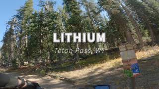
This is an awesome downhill trail. Really fast and flowy at the top. Some gap jumps made from logs will come up on you fast. Trail starts to get really rocky once you hit the ridge. Then the ridge starts to gown down steep and can be loose. Lots of jumps near the bottom. Amazing DH trail Not beginner or intermediate friendly.

Local Trail Association
Traditionally Indigenous Territory
More Stats for Lithium mountain bike trail trail
  • Altitude change
    -2,680 ft
  • Altitude min
    6,513 ft
  • Altitude max
    9,222 ft
  • Altitude start
    9,193 ft
  • Altitude end
    6,512 ft
  • Grade
    -15.1%
  • Grade max
    -73.6%
  • Grade min
    11.3%
  • Distance climb
    1,217 ft
  • Distance down
    3 miles
  • Distance flat
    89 ft
  • Avg time
    00:45:17
  • view trail stats
Status:
on Jun 27, 2023
Ideal
Avg: 4.45 (34 votes)
Your vote: 0

view (944)
close
3D
Trail Conditions
  • Unknown
  • Snow Groomed
  • Snow Packed
  • Snow Covered
  • Snow Cover Inadequate
  • Freeze/thaw Cycle
  • Icy
  • Prevalent Mud
  • Wet
  • Variable
  • Ideal
  • Dry
  • Very Dry
Trail Flow (Ridden Direction)
Trailforks scans users ridelogs to determine the most popular direction each trail is ridden. A good flowing trail network will have most trails flowing in a single direction according to their intension.
The colour categories are based on what percentage of riders are riding a trail in its intended direction.
  • > 96%
  • > 90%
  • > 80%
  • > 70%
  • > 50%
  • < 50%
  • bi-directional trail
  • no data
Trail Last Ridden
Trailforks scans ridelogs to determine the last time a trail was ridden.
  • < 2 days
  • < 1 week
  • < 2 weeks
  • < 1 month
  • < 6 months
  • > 6 months
Trail Ridden Direction
The intended direction a trail should be ridden.
  • Downhill Only
  • Downhill Primary
  • Both Directions
  • Uphill Primary
  • Uphill Only
  • One Direction
Contribute Details
Colors indicate trail is missing specified detail.
  • Description
  • Photos
  • Description & Photos
  • Videos
Trail Popularity ?
Trailforks scans ridelogs to determine which trails are ridden the most in the last 9 months. Trails are compared with nearby trails in the same city region with a possible 25 colour shades. Think of this as a heatmap, more rides = more kinetic energy = warmer colors.
  • most popular
  • popular
  • less popular
  • not popular
ATV/ORV/OHV Filter
Max Vehicle Width
inches

Radar Time
x Activity Recordings
Trailforks users anonymized public ridelogs from the past 6 months.
  • mountain biking recent
  • mountain biking (>6 month)
  • hiking (1 year)
  • moto (1 year)
Activity Recordings
Trailforks users anonymized public skilogs from the past 12 months.
  • Downhill Ski
  • Backcountry Ski
  • Nordic Ski
  • Snowmobile
Winter Trails
Warning A routing network for winter maps does not exist. Selecting trails using the winter trails layer has been disabled.
x Missing Trails
Most Popular
Least Popular
Trails are colored based on popularity. The more popular a trail is, the more red. Less popular trails trend towards green.
Jump Magnitude Heatmap
Heatmap of where riders jump on trails. Zoom in to see individual jumps, click circles to view jump details.
Trails Deemphasized
Trails are shown in grey.
disable
Only show trails with NO bikes.
enable

Save the current map location and zoom level as your default home location whenever this page is loaded.

Save
      Directions to lithium trailhead (43.478500, -110.951710)
      update trails status or condition

      Lithium Trail Reports

      statusdatedescription
      Jun 27, 2023 @ 10:46am
      Jun 27, 2023
      Still some snow drifts on the traverse out there. Otherwise PERFECT!!!
      Jun 18, 2023 @ 11:39am
      Jun 18, 2023
      I rode this yesterday. The top is snow covered and a handful of hike-bike patches a third of the way down from the top. The rest is good fun
      Sep 24, 2022 @ 2:34pm
      Sep 24, 2022
      Absolutely the most perfect it could ever be.
      Aug 19, 2022 @ 8:13am
      Aug 19, 2022
      Total banger
      Jul 22, 2022 @ 6:46pm
      Jul 22, 2022
      Holes and powder Hit it after a good rain
      view all reports »

      Recent Ridelog Activity on Trail

      Past Week
      • 0 rides
      •  
      6 Months
      • 139 rides
      • 14 miles avg distance
      All
      • 933 rides
      • Last: Jul 22, 2023

      Photos

      more »
      173 |
      Aug 1, 2021 @ 3:28pm
      Aug 1, 2021
      148 |
      Aug 1, 2021 @ 3:28pm
      Aug 1, 2021
      136 |
      Aug 1, 2021 @ 3:28pm
      Aug 1, 2021
      118 |
      Aug 1, 2021 @ 3:28pm
      Aug 1, 2021

      Trail Lists

      Routes with this trail

      titledistance
      TSBD (Tour De Teton Pass)25 miles

      8 Reviews & Comments


      We hope you've been enjoying Trailforks!

      Create a FREE account to view trail comments and much more.

      Videos

      more »
      youtuber Finally Rode the wild Lithium Trail! |...
      20:22 | 37 | Oct 11, 2023 , Wilson
      2022 WYORADO - Mountain Biking Wyoming &...
      30:13 | 141 | Sep 21, 2022 , Wilson
      Lithium     --         Teton Pass  |  Wyoming
      5:17 | 761 | Aug 28, 2020 , Wilson
      MTB-TV - Lithium, Teton Pass, Jackson, Wyoming
      32:47 | 931 | Sep 21, 2018 , Wilson
      • By todd Trailforks & contributors
      • #23871 - 15,904 views