1,575 ft
Distance
34 ft
Climb
-77 ft
Descent
00:02:57
Avg time
Local Glory Details
-
Activities
- Mountain Bike
-
Riding AreaMarshall Mountain
Missoula, Montana -
Difficulty Rating
-
Trail TypeSingletrack
-
Bike TypeAM
-
DirectionDownhill OnlyPopular direction shown
-
Physical RatingEasy
-
Trail VisibilityAlways easy to follow
-
eBike Allowed
-
TTFs on TrailBerm
-
Global Ranking#136680 in Mountain Biking
-
Local Popularity95 in Mountain Biking
-
Land OwnerCity of Missoula
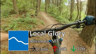
Final section of the standard Marshall descent. It's also a great option for new riders just starting to ride singletrack. The trail enters the woods twists through the trees on a descending traverse. It then drops through a series of quick switchbacks and then straight lines through a grassy field where a few easy pedal strokes return you to the base area.
Local Trail Association
-
Please consider joining or donating to the local trail association to supportdonate to earn trail karma!
trail development & maintenance.
More Stats for Local Glory mountain bike trail trail
-
Altitude change-43 ft
-
Altitude min3,922 ft
-
Altitude max3,993 ft
-
Altitude start3,974 ft
-
Altitude end3,930 ft
-
Grade-2.8%
-
Grade max-30.4%
-
Grade min17.5%
-
Distance climb617 ft
-
Distance down650 ft
-
Distance flat308 ft
-
Avg time00:02:57
-
Avg reverse time00:05:01
- view trail stats
close
3D
Trail Conditions
- Unknown
- Snow Groomed
- Snow Packed
- Snow Covered
- Snow Cover Inadequate
- Freeze/thaw Cycle
- Icy
- Prevalent Mud
- Wet
- Variable
- Ideal
- Dry
- Very Dry
Trail Flow (Ridden Direction)
Trailforks scans users ridelogs to determine the most popular direction each trail is ridden. A good flowing trail network will have most trails flowing in a single direction according to their intension.
The colour categories are based on what percentage of riders are riding a trail in its intended direction.
- > 96%
- > 90%
- > 80%
- > 70%
- > 50%
- < 50%
- bi-directional trail
- no data
Trail Last Ridden
Trailforks scans ridelogs to determine the last time a trail was ridden.
- < 2 days
- < 1 week
- < 2 weeks
- < 1 month
- < 6 months
- > 6 months
Trail Ridden Direction
The intended direction a trail should be ridden.
- Downhill Only
- Downhill Primary
- Both Directions
- Uphill Primary
- Uphill Only
- One Direction
Contribute Details
Colors indicate trail is missing specified detail.
- Description
- Photos
- Description & Photos
- Videos
Trail Popularity ?
Trailforks scans ridelogs to determine which trails are ridden the most in the last 9 months.
Trails are compared with nearby trails in the same city region with a possible 25 colour shades.
Think of this as a heatmap, more rides = more kinetic energy = warmer colors.
- most popular
- popular
- less popular
- not popular
ATV/ORV/OHV Filter
Max Vehicle Width
inches
Radar Time
x
Activity Recordings
Trailforks users anonymized public ridelogs from the past 6 months.
- mountain biking recent
- mountain biking (>6 month)
- hiking (1 year)
- moto (1 year)
Activity Recordings
Trailforks users anonymized public skilogs from the past 12 months.
- Downhill Ski
- Backcountry Ski
- Nordic Ski
- Snowmobile
Winter Trails
Warning
A routing network for winter maps does not exist. Selecting trails using the winter trails layer has been disabled.
x
Missing Trails
Most Popular
Least Popular
Trails are colored based on popularity. The more popular a trail is, the more red. Less popular trails trend towards green.
Jump Magnitude Heatmap
Heatmap of where riders jump on trails. Zoom in to see individual jumps, click circles to view jump details.
Trails Deemphasized
Trails are shown in grey.
Only show trails with NO bikes.
Save the current map location and zoom level as your default home location whenever this page is loaded.
Save
Directions to local-glory trailhead
(46.919150, -113.906370)
update trails status or condition
Local Glory Trail Reports
view all reports »
Recent Ridelog Activity on Trail
Past Week
- 12 rides
- 7 miles avg distance
6 Months
- 434 rides
- 8 miles avg distance
All
- 1,308 rides
- Last: Sep 27, 2023
Photos
no photos have been added for Local Glory yet, add a photo.
Routes with this trail
We hope you've been enjoying Trailforks!
Create a FREE account to view trail comments and much more.
Nearby Trails
- Dual Slalom Connection 210 ft
- Easy Up 541 ft
- Dual Slalom Climb 636 ft
- Cat Track Loop 879 ft
- Dual Slalom 938 ft
- By aaronrbaldwin
TRAILFORKS & contributors
- #458872 - 252 views
- subscribe
- login to download gpx or kml files.