more stats
2.5 miles
Distance
369 ft
Climb
-526 ft
Descent
00:23:27
Avg time
-155 ft
Altitude change
6,978 ft
Altitude min
7,334 ft
Altitude max
7,140 ft
Altitude start
6,985 ft
Altitude end
-1.2%
Grade
-26.1%
Grade max
16.7%
Grade min
1 mile
Distance climb
1 mile
Distance down
640 ft
Distance flat
00:23:27
Avg time

LOV Connection Details

  • Activities
    • Mountain Bike
    • Hike
    • Trail Running
  • Riding Area
    Eagle Ranch
    Eagle, Colorado
  • Difficulty Rating
  • Local Popularity
    95 in Mountain Biking [+]
    • 80 in Trail Running
    • 90 in Hiking
  • Global Ranking
    #43823 in Mountain Biking [+]
    • #79959 in Trail Running
    • #282126 in Hiking
  • Trail Type
    Singletrack
  • Bike Type
    AM, XC
  • Direction
    Both Directions
    Popular Direction Shown
  • Climb Difficulty
    Blue
  • Physical Rating
    Moderate
  • Season
    Closed Dec 15-April 15, Winter Wildlife
  • Dogs Allowed
    Yes
  • eBike Allowed
  • TTFs on Trail
    Bridge
  • Year Opened
    2017
  • Land Owner
    Town of Eagle

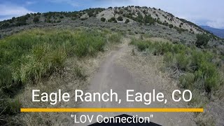
New trail, built by Momentum Trail Concepts in the summer of 2017 with funding from the Town of Eagle. Connects 3rd Gulch to Abrams Gulch with a nice up and down route and great views.

*Closed to all users Dec 1 - Apr 15 each year to protect deer/elk populations

Trail Supporters
  • BLM
    BLM
    Land Manager
Local Trail Association
Traditionally Indigenous Territory

Recent Activity on Trail

Past Week
  • 1 rides
  • 11 miles average
6 Months
  • 39 rides
  • 15 miles avg distance
All
  • 402 rides
  • Last: Jun 29, 2026
c1c2c3c4
January
February
March
April
May
June
July
August
September
October
November
December
Status:
on Jun 2, 2026
Very Dry
Avg: 4.21 (8 votes)
Your vote: 0

view (2,844)
close
3D
Trail Conditions
  • Unknown
  • Snow Groomed
  • Snow Packed
  • Snow Covered
  • Snow Cover Partial
  • Freeze/thaw Cycle
  • Icy
  • Prevalent Mud
  • Wet
  • Variable
  • Ideal
  • Dry
  • Very Dry
Trail Flow (Ridden Direction)
Trailforks scans users ridelogs to determine the most popular direction each trail is ridden. A good flowing trail network will have most trails flowing in a single direction according to their intension.
The colour categories are based on what percentage of riders are riding a trail in its intended direction.
  • > 96%
  • > 90%
  • > 80%
  • > 70%
  • > 50%
  • < 50%
  • bi-directional trail
  • no data
Trail Last Ridden
Trailforks scans ridelogs to determine the last time a trail was ridden.
  • < 2 days
  • < 1 week
  • < 2 weeks
  • < 1 month
  • < 6 months
  • > 6 months
Trail Ridden Direction
The intended direction a trail should be ridden.
  • Downhill Only
  • Downhill Primary
  • Both Directions
  • Uphill Primary
  • Uphill Only
  • One Direction
Contribute Details
Colors indicate trail is missing specified detail.
  • Description
  • Photos
  • Description & Photos
  • Videos
Trail Popularity ?
Trailforks scans ridelogs to determine which trails are ridden the most in the last 9 months. Trails are compared with nearby trails in the same city region with a possible 25 colour shades. Think of this as a heatmap, more rides = more kinetic energy = warmer colors.
  • most popular
  • popular
  • less popular
  • not popular
ATV/ORV/OHV Filter
Max Vehicle Width
inches
US Cell Coverage
Legend
cell carrier legend

Radar Time
Activity Recordings
Trailforks uses anonymized public activity data. ?
Activity Recordings
Trailforks uses anonymized public activity data. ?
Personal Heatmap
Activity Types
all / none
Options
2
Date range month
Winter Trails
Warning A routing network for winter maps does not exist. Selecting trails using the winter trails layer has been disabled.
Missing Trails
Most Popular
Least Popular
Trails are colored based on popularity. The more popular a trail is, the more red. Less popular trails trend towards green.
Jump Magnitude Heatmap
Heatmap of where riders jump on trails. Zoom in to see individual jumps, click circles to view jump details.
BC Backroad Status

Service Road Atlas is a free to use, community-driven service for viewing and creating reports on the numerous back-country service roads around B.C. and Alberta.

map legend
Slope Aspect
Direction the slope faces
Flat N NE E SE S SW W NW
Trails Deemphasized
Trails are shown in grey.
disable
Only show trails with no bike usage.
Enable
Suggested Layers
Based on selected activity type

    Save the current map location and zoom level as your default home location whenever this page is loaded.

    Save
        Directions to lov-connection trailhead (39.610510, -106.803970)

        Photos

        16 more »
        28 |
        Apr 25, 2026 @ 3:39pm
        Apr 25, 2026
        31 |
        Aug 14, 2025 @ 8:04pm
        Aug 14, 2025
        26 |
        Aug 14, 2025 @ 8:04pm
        Aug 14, 2025
        25 |
        Aug 14, 2025 @ 8:04pm
        Aug 14, 2025

        Videos

        3 more »
        Eagle Ranch MTB trail - 'LOV Connection'
        14:19 | 62 | Aug 14, 2025 , Eagle
        LOV Connection Trail Eagle Colorado 2nd downhill
        398 | Jun 18, 2019 , Eagle
        LOV Connection Trail Eagle Colorado 1st...
        397 | Jun 18, 2019 , Eagle

        Routes with this trail

        4.5 9 miles 1,436 ft 9 Point to Point
        A new mostly lower elevation loop that includes our brand new 2017 trail, the LOV Connection, that...
        5.0 5 miles 741 ft 6 Point to Point
        Try out the brand new Trail. This Route takes you from the Arroyo Drive Parking Lot trailhead, up , across...
        10 miles 1,197 ft 5
        Seagulls Send annual short send route

        1 Review & Comments


        We hope you've been enjoying Trailforks!

        Create a FREE account to view trail comments and much more.

        Nearby Trails

        • By LalaTTF Pro HTC & contributors
        • #102909 - 4,400 views

        Frequently Asked Questions About LOV Connection

        Where is LOV Connection located?
        LOV Connection is located in Eagle Ranch, Eagle, Colorado, United States. It is part of the Eagle Ranch trail network. The trailhead is located at coordinates 39.61051, -106.80397.
        How hard is LOV Connection?
        LOV Connection is rated as Blue difficulty. The physical rating is Moderate. The average grade is 1.2%. The climb difficulty is rated Blue.
        What is the elevation gain for LOV Connection?
        LOV Connection has 369 ft of elevation gain. The trail has 526 ft of elevation descent. The elevation ranges from 6,978 ft to 7,334 ft.
        Is LOV Connection a point to point trail?
        LOV Connection is not a point to point trail. The direction is Both Directions. The trail type is singletrack.

        Hit the Trail

        Open in App

        Get this trail on your phone instantly.
        open trail in app

        Download Trail

        Save to wishlist, Garmin & download.
        save the trail

        Find Related Routes

        Find routes and users activities that include this trail.
        find routes for this trail

        You must enter a description before submitting.