more stats
4,518 ft
Distance
245 ft
Climb
-214 ft
Descent
00:09:24
Avg time
29 ft
Altitude change
3,201 ft
Altitude min
3,385 ft
Altitude max
3,201 ft
Altitude start
3,232 ft
Altitude end
0.6%
Grade
-40%
Grade max
30.9%
Grade min
2,326 ft
Distance climb
1,683 ft
Distance down
509 ft
Distance flat
00:09:24
Avg time

Magic Dragon Details

  • Activities
    • Mountain Bike
    • E-Bike
    • Hike
    • Trail Running
  • Riding Area
    Mountain Shadows
    Golden, British Columbia
  • Difficulty Rating
  • Local Popularity
    90 in Mountain Biking [+]
    • 85 in E-Biking
    • 90 in Trail Running
    • 55 in Hiking
  • Global Ranking
    #47830 in Mountain Biking [+]
    • #48415 in E-Biking
    • #34996 in Trail Running
    • #96486 in Hiking
  • Trail Type
    Singletrack
  • Bike Type
    XC
  • Direction
    Both Directions
    Popular Direction Shown
  • Dogs Allowed
    Yes
  • eBike Allowed

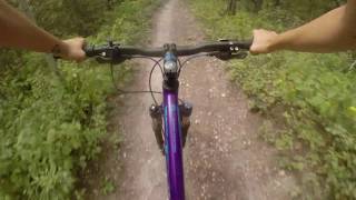
Magic Dragon has several interesting sections of trail which all link together effectively. A substantial part of this trail is descending if ridden in a counter -clockwise direction (recommended). When followed up with Huff & Puff and then Chute the Duck, this combo provides one of the best descents to the valley floor.

Towards it southern half, the height of land for Magic Dragon is marked by a very cool large boulder that will check your shoulder as you pass. This is also where the trail will generally descend to the north. If heading north, ride for several hundred meters and then stay left at the intersection with Cliffside, continuing down Magic Dragon. Hit the hip and then after 25m watch for an easily missed sharp right leading over a drop to another hip banking left. Alternatively, you can skip the sharp right and continue wrapping around right for 20m for the ride around. The next intersection is with Huff & Puff. It is highly recommended to rail this corner to the right, and continue down Huff & Puff for the best value. However, if you continue straight through this intersection, more options also open up to more trails.

Local Trail Association
Traditionally Indigenous Territory

Recent Activity on Trail

Past Week
  • 1 rides
  • 8 miles average
6 Months
  • 29 rides
  • 10 miles avg distance
All
  • 477 rides
  • Last: Jun 23, 2026
c1c2c3c4
January
February
March
April
May
June
July
August
September
October
November
December
Status:
on Apr 11, 2026
Variable
Avg: 4.15 (7 votes)
Your vote: 0

view (4,113)
close
3D
Trail Conditions
  • Unknown
  • Snow Groomed
  • Snow Packed
  • Snow Covered
  • Snow Cover Partial
  • Freeze/thaw Cycle
  • Icy
  • Prevalent Mud
  • Wet
  • Variable
  • Ideal
  • Dry
  • Very Dry
Trail Flow (Ridden Direction)
Trailforks scans users ridelogs to determine the most popular direction each trail is ridden. A good flowing trail network will have most trails flowing in a single direction according to their intension.
The colour categories are based on what percentage of riders are riding a trail in its intended direction.
  • > 96%
  • > 90%
  • > 80%
  • > 70%
  • > 50%
  • < 50%
  • bi-directional trail
  • no data
Trail Last Ridden
Trailforks scans ridelogs to determine the last time a trail was ridden.
  • < 2 days
  • < 1 week
  • < 2 weeks
  • < 1 month
  • < 6 months
  • > 6 months
Trail Ridden Direction
The intended direction a trail should be ridden.
  • Downhill Only
  • Downhill Primary
  • Both Directions
  • Uphill Primary
  • Uphill Only
  • One Direction
Contribute Details
Colors indicate trail is missing specified detail.
  • Description
  • Photos
  • Description & Photos
  • Videos
Trail Popularity ?
Trailforks scans ridelogs to determine which trails are ridden the most in the last 9 months. Trails are compared with nearby trails in the same city region with a possible 25 colour shades. Think of this as a heatmap, more rides = more kinetic energy = warmer colors.
  • most popular
  • popular
  • less popular
  • not popular
ATV/ORV/OHV Filter
Max Vehicle Width
inches
US Cell Coverage
Legend
cell carrier legend

Radar Time
Activity Recordings
Trailforks uses anonymized public activity data. ?
Activity Recordings
Trailforks uses anonymized public activity data. ?
Personal Heatmap
Activity Types
all / none
Options
2
Date range month
Winter Trails
Warning A routing network for winter maps does not exist. Selecting trails using the winter trails layer has been disabled.
Missing Trails
Most Popular
Least Popular
Trails are colored based on popularity. The more popular a trail is, the more red. Less popular trails trend towards green.
Jump Magnitude Heatmap
Heatmap of where riders jump on trails. Zoom in to see individual jumps, click circles to view jump details.
BC Backroad Status

Service Road Atlas is a free to use, community-driven service for viewing and creating reports on the numerous back-country service roads around B.C. and Alberta.

map legend
Slope Aspect
Direction the slope faces
Flat N NE E SE S SW W NW
Trails Deemphasized
Trails are shown in grey.
disable
Only show trails with no bike usage.
Enable
Suggested Layers
Based on selected activity type

    Save the current map location and zoom level as your default home location whenever this page is loaded.

    Save
        Directions to magic-dragon trailhead (51.278960, -116.923820)

        Photos

        7 more »
        108 |
        Aug 1, 2022 @ 7:09am
        Aug 1, 2022
        108 |
        Aug 1, 2022 @ 7:09am
        Aug 1, 2022
        91 |
        Aug 1, 2022 @ 7:08am
        Aug 1, 2022
        93 |
        Sep 20, 2021 @ 9:27pm
        Sep 20, 2021

        Videos

        1 more »
        Ride Golden Like A Girl
        8:50 | 539 | Aug 31, 2018 , Golden

        Routes with this trail

        3.0 6 miles 1,016 ft 12
        9 km loop to get to in the Mountain Shadows area.
        9 miles 1,885 ft 8 Point to Point Race
        Join us September 20, 2025 for a fun, inclusive, ladies enduro! Everyone is welcome. Only 100 spots...
        9 miles 1,695 ft 8 Race
        Join us September 20, 2025 for a fun, inclusive, ladies enduro! Everyone is welcome. Only 100 spots...

        Reviews / Comments

        No reviews yet, be the first to write a review or ask a question.
        Use trail reports to comment on trail conditions.


        We hope you've been enjoying Trailforks!

        Create a FREE account to view trail comments and much more.

        • By canadakaTF Pro Trailforks & contributors
        • #3468 - 2,689 views

        Frequently Asked Questions About Magic Dragon

        Where is Magic Dragon located?
        Magic Dragon is located in Mountain Shadows, Golden, British Columbia, Canada. It is part of the Mountain Shadows trail network. The trailhead is located at coordinates 51.27896, -116.92382.
        How hard is Magic Dragon?
        Magic Dragon is rated as Blue difficulty. The average grade is 0.6%.
        What is the elevation gain for Magic Dragon?
        Magic Dragon has 245 ft of elevation gain. The trail has 214 ft of elevation descent. The elevation ranges from 3,201 ft to 3,385 ft.
        Is Magic Dragon a point to point trail?
        Magic Dragon is not a point to point trail. The direction is Both Directions. The trail type is singletrack.

        Hit the Trail

        Open in App

        Get this trail on your phone instantly.
        open trail in app

        Download Trail

        Save to wishlist, Garmin & download.
        save the trail

        Find Related Routes

        Find routes and users activities that include this trail.
        find routes for this trail

        You must enter a description before submitting.