more stats
3,827 ft
Distance
-567 ft
Descent
00:03:50
Avg time
-567 ft
Altitude change
9,618 ft
Altitude min
10,185 ft
Altitude max
10,185 ft
Altitude start
9,618 ft
Altitude end
-14.811%
Grade
-40.436%
Grade max
1.42%
Grade min
3,737 ft
Distance down
90 ft
Distance flat
00:03:50
Avg time

Magic Forest Details

  • Activities
    • Mountain Bike
    • E-Bike
  • Riding Area
    Vail Mountain
    Vail, Colorado
  • Difficulty Rating
  • Voted Difficulty
    Black Diamond (3 votes)
  • Local Popularity
    70 in Mountain Biking [+]
    • 50 in E-Biking
  • Global Ranking
    #72149 in Mountain Biking
  • Trail Type
    Singletrack
  • Direction
    Downhill Only
    Popular Direction Shown
  • Dogs Allowed
    Yes
  • eBike Allowed

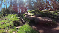
A fun fast downhill trail.

Starts mellow with some open single track and small drops. Nothing mandatory here.
Drops into a magic forest with some mellow table top jumps (10-15')

Typical Vail black diamond. If you have a big bike and are a decent rider, this isn't anything too difficult.

Trail Supporters

  • USFS
    Land Manager

Bike Park

Local Trail Association
Traditionally Indigenous Territory

Recent Activity on Trail

Past Week
  • 1 rides
  • 31 miles average
6 Months
  • 1 rides
  • 31 miles avg distance
All
  • 135 rides
  • Last: Jun 13, 2026
c1c2c3c4
January
February
March
April
May
June
July
August
September
October
November
December
update trails status or condition

Magic Forest Trail Reports

statusdatedescription
Aug 24, 2025 @ 6:03pm
Aug 24, 2025
Still too much snow for this one. Stick to spice rack and below!
Jun 24, 2024 @ 1:47pm
Jun 24, 2024
reporter Most trails on Vail Mountain are dry. Some still have snow and downed trees. Please respect individual closures posted by Vail Resorts
Jun 24, 2024 @ 6:25am
Jun 24, 2024
Vail's website says this is still closed?
Mar 28, 2024 @ 12:52pm
Mar 28, 2024
reporter It's ski season - go ski!
Sep 16, 2023 @ 3:00pm
Sep 16, 2023
more »
Status:
on Aug 24, 2025
Snow Covered
Avg: 4.3 (7 votes)
Your vote: 0

view (1,803)
close
3D
Trail Conditions
  • Unknown
  • Snow Groomed
  • Snow Packed
  • Snow Covered
  • Snow Cover Partial
  • Freeze/thaw Cycle
  • Icy
  • Prevalent Mud
  • Wet
  • Variable
  • Ideal
  • Dry
  • Very Dry
Trail Flow (Ridden Direction)
Trailforks scans users ridelogs to determine the most popular direction each trail is ridden. A good flowing trail network will have most trails flowing in a single direction according to their intension.
The colour categories are based on what percentage of riders are riding a trail in its intended direction.
  • > 96%
  • > 90%
  • > 80%
  • > 70%
  • > 50%
  • < 50%
  • bi-directional trail
  • no data
Trail Last Ridden
Trailforks scans ridelogs to determine the last time a trail was ridden.
  • < 2 days
  • < 1 week
  • < 2 weeks
  • < 1 month
  • < 6 months
  • > 6 months
Trail Ridden Direction
The intended direction a trail should be ridden.
  • Downhill Only
  • Downhill Primary
  • Both Directions
  • Uphill Primary
  • Uphill Only
  • One Direction
Contribute Details
Colors indicate trail is missing specified detail.
  • Description
  • Photos
  • Description & Photos
  • Videos
Trail Popularity ?
Trailforks scans ridelogs to determine which trails are ridden the most in the last 9 months. Trails are compared with nearby trails in the same city region with a possible 25 colour shades. Think of this as a heatmap, more rides = more kinetic energy = warmer colors.
  • most popular
  • popular
  • less popular
  • not popular
ATV/ORV/OHV Filter
Max Vehicle Width
inches
US Cell Coverage
Legend
cell carrier legend

Radar Time
Activity Recordings
Trailforks uses anonymized public activity data. ?
Activity Recordings
Trailforks uses anonymized public activity data. ?
Personal Heatmap
Activity Types
all / none
Options
2
Date range month
Winter Trails
Warning A routing network for winter maps does not exist. Selecting trails using the winter trails layer has been disabled.
Missing Trails
Most Popular
Least Popular
Trails are colored based on popularity. The more popular a trail is, the more red. Less popular trails trend towards green.
Jump Magnitude Heatmap
Heatmap of where riders jump on trails. Zoom in to see individual jumps, click circles to view jump details.
BC Backroad Status

Service Road Atlas is a free to use, community-driven service for viewing and creating reports on the numerous back-country service roads around B.C. and Alberta.

map legend
Slope Aspect
Direction the slope faces
Flat N NE E SE S SW W NW
Trails Deemphasized
Trails are shown in grey.
disable
Only show trails with no bike usage.
Enable
Suggested Layers
Based on selected activity type

    Save the current map location and zoom level as your default home location whenever this page is loaded.

    Save
        Directions to magic-forest trailhead (39.619524, -106.380079)

        Photos

        15 more »
        305 |
        Sep 3, 2017 @ 3:26pm
        Sep 3, 2017
        1,025 |
        Mar 6, 2009 @ 9:47pm
        Mar 6, 2009
        214 |
        Sep 3, 2017 @ 3:26pm
        Sep 3, 2017
        487 |
        Aug 20, 2017 @ 1:36pm
        Aug 20, 2017

        Videos

        1 more »
        Vail bike park Crash
        0:05 | 196 | Jul 15, 2022 , Vail

        6 Reviews & Comments


        We hope you've been enjoying Trailforks!

        Create a FREE account to view trail comments and much more.

        • By toddTF Pro Trailforks & contributors
        • #14155 - 3,186 views

        Frequently Asked Questions About Magic Forest

        Where is Magic Forest located?
        Magic Forest is located in Vail Mountain, Vail, Colorado, United States. It is part of the Vail Mountain trail network. The trailhead is located at coordinates 39.61952, -106.38008.
        How hard is Magic Forest?
        Magic Forest is rated as Black Diamond difficulty. The average grade is 14.811%.
        What is the elevation gain for Magic Forest?
        The trail has 567 ft of elevation descent. The elevation ranges from 9,618 ft to 10,185 ft.
        Is Magic Forest a point to point trail?
        Yes, Magic Forest is a point to point trail. The direction is Downhill Only. The trail type is singletrack.

        Hit the Trail

        Open in App

        Get this trail on your phone instantly.
        open trail in app

        Download Trail

        Save to wishlist, Garmin & download.
        save the trail

        Find Related Routes

        Find routes and users activities that include this trail.
        find routes for this trail

        You must enter a description before submitting.