4,981 ft
Distance
87 ft
Climb
-943 ft
Descent
00:18:33
Avg time
Middle Della Details
-
Activities
- Mountain Bike
- Hike
- Trail Running
-
Riding AreaLillooet
, British Columbia -
Difficulty Rating
-
Trail TypeSingletrack
-
Trail UsageBiking Primary
-
DirectionDownhill PrimaryPopular direction shown
-
Climb DifficultyDouble Black Diamond
-
Dogs AllowedYes
-
Global Ranking#38421 in Mountain Biking
-
Local Popularity90 in Mountain Biking [+]
- 5 in Trail Running
- 5 in Hiking
Pedal access only due to rock slide on the access road above 1300m. The road gets steeper but is manageable & is line with lots of nice mountain flowers.
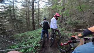
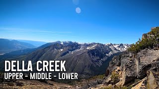
The trail is nice single track through the forest with lots of flat corners. It ends with a few loose, steep, spicy switchbacks above a cliff to bring you back to the shuttle road where you can enjoy a view & link to Lower Della.
Local Trail Association
-
Please consider joining or donating to the local trail association to supportdonate to earn trail karma!
trail development & maintenance.
Traditionally Indigenous Territory
More Stats for Middle Della mountain bike trail trail
-
Altitude change-856 ft
-
Altitude min4,136 ft
-
Altitude max4,993 ft
-
Altitude start4,993 ft
-
Altitude end4,136 ft
-
Grade-17.19%
-
Grade max-75.067%
-
Grade min50.483%
-
Distance climb666 ft
-
Distance down3,930 ft
-
Distance flat385 ft
-
Avg time00:18:33
- view trail stats
close
Trail Conditions
- Unknown
- Snow Groomed
- Snow Packed
- Snow Covered
- Freeze/thaw Cycle
- Icy
- Prevalent Mud
- Wet
- Variable
- Ideal
- Dry
- Very Dry
Trail Ridden Direction
Trailforks scans users ridelogs to determine the most popular direction each trail is ridden. A good flowing trail network will have most trails flowing in a single direction according to their intension.
The colour categories are based on what percentage of riders are riding a trail in its intended direction.
- > 96%
- > 90%
- > 80%
- > 70%
- > 50%
- < 50%
Trail Last Ridden
Trailforks scans ridelogs to determine the last time a trail was ridden.
- < 2 days
- < 1 week
- < 2 weeks
- < 1 month
- < 6 months
- > 6 months
Trail Ridden Direction
The intended direction a trail should be ridden.
- Downhill Only
- Downhill Primary
- Both Directions
- Uphill Primary
- Uphill Only
- One Direction
Contribute Details
Colors indicate trail is missing specified detail.
- Description
- Photos
- Description & Photos
- Videos
Trail Popularity ?
Trailforks scans ridelogs to determine which trails are ridden the most in the last 9 months.
Trails are compared with nearby trails in the same city region with a possible 25 colour shades.
Think of this as a heatmap, more rides = more kinetic energy = warmer colors.
- most popular
- popular
- less popular
- not popular
ATV/ORV/OHV Filter
Max Vehicle Width
inches
Radar Time
LEGEND
Trail Difficulties
Trail Report Status
- Access Road/Trail
- White
- Green
- Blue
- Black
- Double Black Diamond
Trail Report Status
- Clear / Green
- Minor Issue / Yellow
- Significant Issue / Amber
- Closed
- Land Owner Overlay
- Wilderness (typically no bikes in USA)
- BLM (public)
- USFS (Wildlife sanctuaries darker than usfs)
- State land
- Indigenous
- Military
Trail Conditions
- Unknown
- Snow Groomed
- Snow Packed
- Snow Covered
- Freeze/thaw Cycle
- Icy
- Prevalent Mud
- Wet
- Variable
- Ideal
- Dry
- Very Dry
- Map Markers
Trail Head
Photo
Directory Listing
Riding Area
TTF
Parking
Viewpoint
Information
Warning
Directions
Sight
Restrooms
eBike Charging Point
Water Fountain/Source
Gate
Trail Sign
Table or Bench
Ladder
Stairs
Bridge
Boardwalk
Camping
Cabin
Lodge
Bear Cache
Dock
Ranger Station
Summit
Other
Directions to middle-della trailhead
(50.475420, -121.774370)
update trails status or condition
Middle Della Trail Reports
view all reports »
Recent Ridelog Activity on Trail
Past Week
- 0 rides
6 Months
- 1 rides
- 6 miles avg distance
All
- 62 rides
Photos
more »
-
+ 0
jstromgren
BCBR (Sep 26, 2017 at 18:52)
Nice descent. Great shape. Consequences at the very bottom are severe if there's a mishap; be careful
[Reply]
Samisasnowboarder
(Jun 3, 2020 at 17:45)
Trail is in great condition but the upper half has 8 trees down over the trail. I cleared it up with a machete so you can lift your bike over them and it’s perfect in between the trees down.
[Reply]
Videos
no videos have been added for Middle Della yet, add a video.
Nearby Trails
- Della Creek 1 mile
- Della Creek Access 3 miles
- Upper Della 4 miles
- Bottane Burn 27 miles
- embed Middle Della trail on your website
- By BCpov
Plus & contributors
- #71089 - 1,659 views
- subscribe
- login to download gpx or kml files.
Open trail in mobile app