2 miles
Distance
45 ft
Climb
-610 ft
Descent
00:12:00
Avg time
Trail Supporters, Builders & Maintainers of Middle Fork Trail
USFSLand Manager
Middle Fork Details
-
Activities
- Mountain Bike
-
Riding AreaSnowbasin Resort
Ogden, Utah -
Difficulty Rating
-
Voted DifficultyBlue (1 vote)
-
Trail TypeSingletrack
-
Trail UsageMulti-use
-
DirectionBoth Directions
-
Climb DifficultyBlue
-
Physical RatingModerate
-
SeasonMay - Oct.
-
Dogs AllowedYes
-
eBike Allowed
-
TTFs on TrailRock Garden
-
Global Ranking#31240 in Mountain Biking
-
Local Popularity75 in Mountain Biking
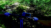
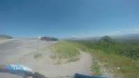
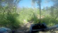
Pretty fast trail with good flow but plenty of rocks and ruts to keep you occupied. Mostly in the shade for cooler riding during the summer. Trail can get pretty beat up at times. Watch out for the moose.
Traditionally Indigenous Territory
More Stats for Middle Fork mountain bike trail trail
-
Altitude change-565 ft
-
Altitude min5,648 ft
-
Altitude max6,228 ft
-
Altitude start6,213 ft
-
Altitude end5,648 ft
-
Grade-6.118%
-
Grade max-66.165%
-
Grade min20.621%
-
Distance climb835 ft
-
Distance down2 miles
-
Distance flat322 ft
-
Avg time00:12:00
-
Avg reverse time00:26:07
- view trail stats
close
Trail Conditions
- Unknown
- Snow Groomed
- Snow Packed
- Snow Covered
- Freeze/thaw Cycle
- Icy
- Prevalent Mud
- Wet
- Variable
- Ideal
- Dry
- Very Dry
Trail Ridden Direction
Trailforks scans users ridelogs to determine the most popular direction each trail is ridden. A good flowing trail network will have most trails flowing in a single direction according to their intension.
The colour categories are based on what percentage of riders are riding a trail in its intended direction.
- > 96%
- > 90%
- > 80%
- > 70%
- > 50%
- < 50%
Trail Last Ridden
Trailforks scans ridelogs to determine the last time a trail was ridden.
- < 2 days
- < 1 week
- < 2 weeks
- < 1 month
- < 6 months
- > 6 months
Trail Ridden Direction
The intended direction a trail should be ridden.
- Downhill Only
- Downhill Primary
- Both Directions
- Uphill Primary
- Uphill Only
- One Direction
Contribute Details
Colors indicate trail is missing specified detail.
- Description
- Photos
- Description & Photos
- Videos
Trail Popularity ?
Trailforks scans ridelogs to determine which trails are ridden the most in the last 9 months.
Trails are compared with nearby trails in the same city region with a possible 25 colour shades.
Think of this as a heatmap, more rides = more kinetic energy = warmer colors.
- most popular
- popular
- less popular
- not popular
ATV/ORV/OHV Filter
Max Vehicle Width
inches
Radar Time
LEGEND
Trail Difficulties
Trail Report Status
- Access Road/Trail
- White
- Green
- Blue
- Black
- Double Black Diamond
Trail Report Status
- Clear / Green
- Minor Issue / Yellow
- Significant Issue / Amber
- Closed
- Land Owner Overlay
- Wilderness (typically no bikes in USA)
- BLM (public)
- USFS (Wildlife sanctuaries darker than usfs)
- State land
- Indigenous
- Military
Trail Conditions
- Unknown
- Snow Groomed
- Snow Packed
- Snow Covered
- Freeze/thaw Cycle
- Icy
- Prevalent Mud
- Wet
- Variable
- Ideal
- Dry
- Very Dry
- Map Markers
Trail Head
Photo
Directory Listing
Riding Area
TTF
Parking
Viewpoint
Information
Warning
Directions
Sight
Restrooms
eBike Charging Point
Water Fountain/Source
Gate
Trail Sign
Table or Bench
Ladder
Stairs
Bridge
Boardwalk
Camping
Cabin
Lodge
Bear Cache
Dock
Ranger Station
Summit
Other
Directions to middle-fork trailhead
(41.207540, -111.833290)
update trails status or condition
Middle Fork Trail Reports
view all reports »
Recent Ridelog Activity on Trail
Past Week
- 3 rides
- 11 miles avg distance
6 Months
- 208 rides
- 13 miles avg distance
All
- 1,305 rides
Photos
more »
Routes with this trail
-
+ 1

Don't climb this trail. Just descend it!
[Reply]
Videos
more »
Nearby Trails
- Green Pond 1,115 ft
- Snowbasin 3,363 ft
- Last Chance 1 mile
- Green Pond 1 mile
- Needles (lower) 1 mile
- embed Middle Fork trail on your website
- By todd
Trailforks Plus & contributors
- #11002 - 1,945 views
- subscribe
- login to download gpx or kml files.
Open trail in mobile app