more stats
1.3 miles
Distance
120 ft
Climb
-141 ft
Descent
1,557 ft
High Point
-21 ft
Altitude change
1,449 ft
Altitude min
1,538 ft
Altitude start
1,516 ft
Altitude end
-0.3%
Grade
-11.5%
Grade max
14.2%
Grade min
2,434 ft
Distance climb
3,045 ft
Distance down
1,516 ft
Distance flat

Missing Link Details

  • Activities
    • Mountain Bike
    • E-Bike
    • Hike
    • Trail Running
    • Snowshoe
  • Riding Area
    CAMBA Cable Cluster
    Cable, Wisconsin
  • Difficulty Rating
  • Local Popularity
    95 in Mountain Biking [+]
    • 85 in E-Biking
    • 95 in Trail Running
    • 95 in Hiking
    • 5 in Snowshoeing
  • Global Ranking
    #7893 in Mountain Biking [+]
    • #18364 in Hiking
  • Hiking SAC Scale
    T1 Hiking
  • Trail Type
    Singletrack
  • Snow Grooming
    Backcountry
  • Bike Type
    AM, XC
  • Direction
    Both Directions
  • Climb Difficulty
    Green
  • Physical Rating
    Easy
  • Trail Visibility
    Always easy to follow
  • Dogs Allowed
    Yes
  • eBike Allowed
    Yes up to Class 1
  • Year Opened
    2023
  • Land Owner
    Bayfield County Forest

No community description for Missing Link trail has been added yet!

AI Generated Description

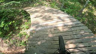
Missing Link is a 1 mile popular blue difficulty singletrack trail located near Cable Wisconsin. This mountain bike primary trail can be used both directions and has a easy overall physical rating with a 120 ft green climb. Winter use: Backcountry snow grooming. Trail visibility is always easy to follow.

Access Info

Begins/ends at the halfway point of Evenflow as well as the Downward spiral section of Dirt Candy 1.

Local Trail Association

Recent Activity on Trail

Past Week
  • 6 rides
  • 26 miles average
6 Months
  • 31 rides
  • 22 miles avg distance
All
  • 176 rides
  • Last: Jul 3, 2026
c1c2c3c4
January
February
March
April
May
June
July
August
September
October
November
December
update trails status or condition

Missing Link Trail Reports

statusdatedescription
May 2, 2026 @ 10:09am (America/Chicago)
May 2, 2026
reporter
Mar 21, 2026 @ 10:15am (America/Chicago)
Mar 21, 2026
reporter
Nov 22, 2025 @ 6:30am (America/Chicago)
Nov 22, 2025
reporter Closed for hunting season. Private land please respect
May 3, 2025 @ 4:39am
May 3, 2025
reporter Out and back until nirvana opens.
Mar 10, 2025 @ 2:07pm
Mar 10, 2025
reporter
more »
Status:
on May 2, 2026
Variable
Avg: 4.08 (5 votes)
Your vote: 0

view (952)
close
3D
Trail Conditions
  • Unknown
  • Snow Groomed
  • Snow Packed
  • Snow Covered
  • Snow Cover Partial
  • Freeze/thaw Cycle
  • Icy
  • Prevalent Mud
  • Wet
  • Variable
  • Ideal
  • Dry
  • Very Dry
Trail Flow (Ridden Direction)
Trailforks scans users ridelogs to determine the most popular direction each trail is ridden. A good flowing trail network will have most trails flowing in a single direction according to their intension.
The colour categories are based on what percentage of riders are riding a trail in its intended direction.
  • > 96%
  • > 90%
  • > 80%
  • > 70%
  • > 50%
  • < 50%
  • bi-directional trail
  • no data
Trail Last Ridden
Trailforks scans ridelogs to determine the last time a trail was ridden.
  • < 2 days
  • < 1 week
  • < 2 weeks
  • < 1 month
  • < 6 months
  • > 6 months
Trail Ridden Direction
The intended direction a trail should be ridden.
  • Downhill Only
  • Downhill Primary
  • Both Directions
  • Uphill Primary
  • Uphill Only
  • One Direction
Contribute Details
Colors indicate trail is missing specified detail.
  • Description
  • Photos
  • Description & Photos
  • Videos
Trail Popularity ?
Trailforks scans ridelogs to determine which trails are ridden the most in the last 9 months. Trails are compared with nearby trails in the same city region with a possible 25 colour shades. Think of this as a heatmap, more rides = more kinetic energy = warmer colors.
  • most popular
  • popular
  • less popular
  • not popular
ATV/ORV/OHV Filter
Max Vehicle Width
inches
US Cell Coverage
Legend
cell carrier legend

Radar Time
Activity Recordings
Trailforks uses anonymized public activity data. ?
Activity Recordings
Trailforks uses anonymized public activity data. ?
Personal Heatmap
Activity Types
all / none
Options
2
Date range month
Winter Trails
Warning A routing network for winter maps does not exist. Selecting trails using the winter trails layer has been disabled.
Missing Trails
Most Popular
Least Popular
Trails are colored based on popularity. The more popular a trail is, the more red. Less popular trails trend towards green.
Jump Magnitude Heatmap
Heatmap of where riders jump on trails. Zoom in to see individual jumps, click circles to view jump details.
BC Backroad Status

Service Road Atlas is a free to use, community-driven service for viewing and creating reports on the numerous back-country service roads around B.C. and Alberta.

map legend
Slope Aspect
Direction the slope faces
Flat N NE E SE S SW W NW
Trails Deemphasized
Trails are shown in grey.
disable
Only show trails with no bike usage.
Enable
Suggested Layers
Based on selected activity type

    Save the current map location and zoom level as your default home location whenever this page is loaded.

    Save
        Directions to missing-link-716182 trailhead (46.180530, -91.256240)

        Photos

        0 more »
        32 |
        Aug 19, 2024 @ 4:36pm
        Aug 19, 2024
        54 |
        May 29, 2024 @ 9:20am
        May 29, 2024
        66 |
        May 7, 2024 @ 5:07am
        May 7, 2024

        Videos

        1 more »
        Missing Link and Dirt Candy Trail Tour.
        15:51 | 83 | Jul 6, 2025 , Cable

        Routes with this trail

        7 miles 573 ft 5 Loop
        Wisconsin League Adventure for Cable
        10 miles 872 ft 7 Loop
        Wisconsin NICA Spicy Adventure for Cable
        34 miles 2,467 ft 8
        Camba single track going north to gravel around lake Helene then back to single track to Telemark Trails

        Reviews / Comments

        No reviews yet, be the first to write a review or ask a question.
        Use trail reports to comment on trail conditions.


        We hope you've been enjoying Trailforks!

        Create a FREE account to view trail comments and much more.

        • By Meatloaf5TF Pro & contributors
        • #716182 - 590 views

        Frequently Asked Questions About Missing Link

        Where is Missing Link located?
        Missing Link is located in CAMBA Cable Cluster, Cable, Wisconsin, United States. It is part of the CAMBA Cable Cluster trail network. The trailhead is located at coordinates 46.18053, -91.25624.
        How hard is Missing Link?
        Missing Link is rated as Blue difficulty. The physical rating is Easy. The average grade is 0.3%. The climb difficulty is rated Green.
        What is the elevation gain for Missing Link?
        Missing Link has 120 ft of elevation gain. The trail has 141 ft of elevation descent. The elevation ranges from 1,449 ft to 1,557 ft.
        Is Missing Link a point to point trail?
        Missing Link is not a point to point trail. The direction is Both Directions. The trail type is singletrack.

        Hit the Trail

        Open in App

        Get this trail on your phone instantly.
        open trail in app

        Download Trail

        Save to wishlist, Garmin & download.
        save the trail

        Find Related Routes

        Find routes and users activities that include this trail.
        find routes for this trail

        You must enter a description before submitting.