more stats
1.1 miles
Distance
33 ft
Climb
-574 ft
Descent
00:08:31
Avg time
-541 ft
Altitude change
3,335 ft
Altitude min
3,891 ft
Altitude max
3,890 ft
Altitude start
3,350 ft
Altitude end
-9%
Grade
-42.8%
Grade max
11.1%
Grade min
1,201 ft
Distance climb
4,580 ft
Distance down
262 ft
Distance flat
00:08:31
Avg time

Moral Details

  • Activities
    • Mountain Bike
    • E-Bike
    • Hike
    • Trail Running
  • Riding Area
    Cerro del Telégrafo
    Moralzarzal
  • AKA
    DH Moral
  • Difficulty Rating
  • Voted Difficulty
    Red (2 votes)
  • Local Popularity
    65 in Mountain Biking [+]
    • 80 in E-Biking
    • 5 in Trail Running
    • 5 in Hiking
  • Global Ranking
    #71376 in Mountain Biking [+]
    • #26013 in E-Biking
    • #131346 in Trail Running
    • #124475 in Hiking
  • Hiking SAC Scale
    T1 Hiking
  • Trail Type
    Singletrack
  • Bike Type
    DH, AM
  • Direction
    Downhill Only
    Popular Direction Shown
  • Trail Visibility
    Always easy to follow
  • Dogs Allowed
    Yes
  • eBike Allowed
    Yes up to Class 1
  • TTFs on Trail
    Jump, Rock Face
  • Ride in Rain
    Yes
  • Land Owner
    Comunidad de Madrid

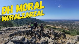
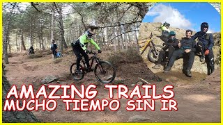
Mitico circuito de DH en la Comunidad de Madrid donde se albergaron carreras de descenso en el pasado. En los ultimos años ha sufrido modificaciones y mejoras por la comunidad y actualmente es una de las bajadas imprescindibles cada vez que visitas el cerro.

Usado comunmente en los enduros de Moralzarzal y reconocido oficialmente por IMBA, podrás disfrutar del sendero sin miedo a ser sancionado.

Circuito muy rapido y divertido que discurre en su totalidad por bosque, repleto de saltos ,curvas y piedras, nunca defrauda.

This trail is unsanctioned.

Recent Activity on Trail

Past Week
  • 1 rides
  • 30.7 km average
6 Months
  • 7 rides
  • 25.1 km avg distance
All
  • 62 rides
  • Last: Jun 20, 2026
c1c2c3c4
January
February
March
April
May
June
July
August
September
October
November
December
update trails status or condition

Moral Trail Reports

statusdatedescription
Apr 26, 2026 @ 9:19am (Europe/Madrid)
Apr 26, 2026
esta muy sucia pero sigue siendo ciclable, estaba muy polvorienta cuidado con algun bancal de arena
Dec 19, 2025 @ 10:07am (Europe/Madrid)
Dec 19, 2025
Jul 5, 2025 @ 11:46am
Jul 5, 2025
reporter Al igual que Trail to Hell, se nota que han hecho trabajos para recuperarlo y mantenerlo pero aún así está muy deteriorado.
Apr 19, 2025 @ 10:59am
Apr 19, 2025
Dec 7, 2024 @ 10:39am
Dec 7, 2024
more »
Status:
on Apr 26, 2026
Very Dry
Avg: 3.81 (5 votes)
Your vote: 0

view (841)
close
3D
Trail Conditions
  • Unknown
  • Snow Groomed
  • Snow Packed
  • Snow Covered
  • Snow Cover Partial
  • Freeze/thaw Cycle
  • Icy
  • Prevalent Mud
  • Wet
  • Variable
  • Ideal
  • Dry
  • Very Dry
Trail Flow (Ridden Direction)
Trailforks scans users ridelogs to determine the most popular direction each trail is ridden. A good flowing trail network will have most trails flowing in a single direction according to their intension.
The colour categories are based on what percentage of riders are riding a trail in its intended direction.
  • > 96%
  • > 90%
  • > 80%
  • > 70%
  • > 50%
  • < 50%
  • bi-directional trail
  • no data
Trail Last Ridden
Trailforks scans ridelogs to determine the last time a trail was ridden.
  • < 2 days
  • < 1 week
  • < 2 weeks
  • < 1 month
  • < 6 months
  • > 6 months
Trail Ridden Direction
The intended direction a trail should be ridden.
  • Downhill Only
  • Downhill Primary
  • Both Directions
  • Uphill Primary
  • Uphill Only
  • One Direction
Contribute Details
Colors indicate trail is missing specified detail.
  • Description
  • Photos
  • Description & Photos
  • Videos
Trail Popularity ?
Trailforks scans ridelogs to determine which trails are ridden the most in the last 9 months. Trails are compared with nearby trails in the same city region with a possible 25 colour shades. Think of this as a heatmap, more rides = more kinetic energy = warmer colors.
  • most popular
  • popular
  • less popular
  • not popular
ATV/ORV/OHV Filter
Max Vehicle Width
inches
US Cell Coverage
Legend
cell carrier legend

Radar Time
Activity Recordings
Trailforks uses anonymized public activity data. ?
Activity Recordings
Trailforks uses anonymized public activity data. ?
Personal Heatmap
Activity Types
all / none
Options
2
Date range month
Winter Trails
Warning A routing network for winter maps does not exist. Selecting trails using the winter trails layer has been disabled.
Missing Trails
Most Popular
Least Popular
Trails are colored based on popularity. The more popular a trail is, the more red. Less popular trails trend towards green.
Jump Magnitude Heatmap
Heatmap of where riders jump on trails. Zoom in to see individual jumps, click circles to view jump details.
BC Backroad Status

Service Road Atlas is a free to use, community-driven service for viewing and creating reports on the numerous back-country service roads around B.C. and Alberta.

map legend
Slope Aspect
Direction the slope faces
Flat N NE E SE S SW W NW
Trails Deemphasized
Trails are shown in grey.
disable
Only show trails with no bike usage.
Enable
Suggested Layers
Based on selected activity type

    Save the current map location and zoom level as your default home location whenever this page is loaded.

    Save
        Directions to moral trailhead (40.683700, -3.985400)

        Photos

        16 more »
        24 |
        Dec 19, 2025 @ 1:09am
        Dec 19, 2025
        29 |
        Dec 19, 2025 @ 1:09am
        Dec 19, 2025
        59 |
        May 7, 2023 @ 10:47am
        May 7, 2023
        57 |
        May 7, 2023 @ 10:47am
        May 7, 2023

        Videos

        32 more »
        youtuber ‍♀️⛰ DH Moral| Moralzarzal (Madrid) |...
        5:28 | 141 | Sep 14, 2024 , Moralzarzal
        youtuber ‍♀️⛰ DH Moral| Moralzarzal (Madrid) |...
        5:28 | 70 | Sep 15, 2024 , Moralzarzal
        youtuber Amazing Trails ️  4 años sin montar por...
        8:28 | 89 | Mar 6, 2023 , Moralzarzal
        youtuber The Best Enduro Mountain Bike You've Never...
        9:56 | 539 | Mar 4, 2019 , Moralzarzal

        Reviews / Comments

        No reviews yet, be the first to write a review or ask a question.
        Use trail reports to comment on trail conditions.


        We hope you've been enjoying Trailforks!

        Create a FREE account to view trail comments and much more.

        • #41963 - 4,680 views

        Frequently Asked Questions About Moral

        Where is Moral located?
        Moral is located in Cerro del Telégrafo, Moralzarzal, Spain. It is part of the Cerro del Telégrafo trail network. The trailhead is located at coordinates 40.6837, -3.9854.
        How hard is Moral?
        Moral is rated as Red difficulty. The average grade is 9%.
        What is the elevation gain for Moral?
        Moral has 10 m of elevation gain. The trail has 175 m of elevation descent. The elevation ranges from 1,017 m to 1,186 m.
        Is Moral a point to point trail?
        Yes, Moral is a point to point trail. The direction is Downhill Only. The trail type is singletrack.

        Hit the Trail

        Open in App

        Get this trail on your phone instantly.
        open trail in app

        Download Trail

        Save to wishlist, Garmin & download.
        save the trail

        Find Related Routes

        Find routes and users activities that include this trail.
        find routes for this trail

        You must enter a description before submitting.