more stats
1.5 miles
Distance
439 ft
Climb
-382 ft
Descent
00:27:20
Avg time
57 ft
Altitude change
6,455 ft
Altitude min
6,795 ft
Altitude max
6,455 ft
Altitude start
6,512 ft
Altitude end
0.739%
Grade
-92.953%
Grade max
90.331%
Grade min
3,815 ft
Distance climb
3,201 ft
Distance down
674 ft
Distance flat
00:27:20
Avg time

Morrison Slide Details

  • Activities
    • Mountain Bike
    • E-Bike
    • Hike
    • Trail Running
  • Riding Area
    Morrison
    , Colorado
  • Difficulty Rating
  • Voted Difficulty
    Black Diamond (2 votes)
  • Local Popularity
    55 in Mountain Biking [+]
    • 25 in E-Biking
    • 95 in Trail Running
    • 95 in Hiking
  • Global Ranking
    #98074 in Mountain Biking [+]
    • #16025 in E-Biking
    • #19958 in Trail Running
    • #22539 in Hiking
  • Trail Type
    Singletrack
  • Direction
    Both Directions
  • Climb Difficulty
    Black Diamond
  • Physical Rating
    Hard
  • Dogs Allowed
    Yes
  • eBike Allowed
    Yes up to Class 1
  • Land Owner

-Climbing
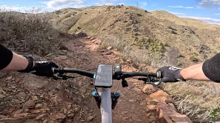
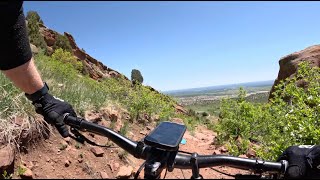
North half of the trail is easier to climb up for sure. You have to have some trial skills to be able to clean some of the South half sections if you're climbing up.
-Descending
South side of the trail is slightly more technically but has many TIGHT switchbacks that make you slow down to a crawl. There are also some very technical sections that won't allow you to pass other bikers or hikers so be careful.
North side allows more speed/flow to be carried through the trail even though it has its still has tech sections and switchbacks.

Recommended ride would be ride up the north end and back down the north end. But if you want to make a loop of it, it would depend on what your priorities are, my vote is north to south since it'd minimize your time walking the bike up.

Local Trail Association
Traditionally Indigenous Territory

Recent Activity on Trail

Past Week
  • 3 rides
  • 9 miles average
6 Months
  • 40 rides
  • 10 miles avg distance
All
  • 265 rides
  • Last: Jun 28, 2026
c1c2c3c4
January
February
March
April
May
June
July
August
September
October
November
December
update trails status or condition

Morrison Slide Trail Reports

statusdatedescription
May 12, 2026 @ 6:38am (America/Denver)
May 12, 2026
Apr 18, 2026 @ 1:08pm (America/Denver)
Apr 18, 2026
Well maintained trails. Clean bathroom la beautiful views.
Mar 13, 2025 @ 2:53pm
Mar 13, 2025
Mostly excellent riding. A few of the darker/north facing areas still have mud and a fraction of those have snow/ice. If you’re hesitant,...
Sep 29, 2024 @ 11:10am
Sep 29, 2024
Aug 22, 2024 @ 7:49pm
Aug 22, 2024
more »
Status:
on May 12, 2026
Dry
Avg: 3.88 (12 votes)
Your vote: 0

view (3,261)
close
3D
Trail Conditions
  • Unknown
  • Snow Groomed
  • Snow Packed
  • Snow Covered
  • Snow Cover Partial
  • Freeze/thaw Cycle
  • Icy
  • Prevalent Mud
  • Wet
  • Variable
  • Ideal
  • Dry
  • Very Dry
Trail Flow (Ridden Direction)
Trailforks scans users ridelogs to determine the most popular direction each trail is ridden. A good flowing trail network will have most trails flowing in a single direction according to their intension.
The colour categories are based on what percentage of riders are riding a trail in its intended direction.
  • > 96%
  • > 90%
  • > 80%
  • > 70%
  • > 50%
  • < 50%
  • bi-directional trail
  • no data
Trail Last Ridden
Trailforks scans ridelogs to determine the last time a trail was ridden.
  • < 2 days
  • < 1 week
  • < 2 weeks
  • < 1 month
  • < 6 months
  • > 6 months
Trail Ridden Direction
The intended direction a trail should be ridden.
  • Downhill Only
  • Downhill Primary
  • Both Directions
  • Uphill Primary
  • Uphill Only
  • One Direction
Contribute Details
Colors indicate trail is missing specified detail.
  • Description
  • Photos
  • Description & Photos
  • Videos
Trail Popularity ?
Trailforks scans ridelogs to determine which trails are ridden the most in the last 9 months. Trails are compared with nearby trails in the same city region with a possible 25 colour shades. Think of this as a heatmap, more rides = more kinetic energy = warmer colors.
  • most popular
  • popular
  • less popular
  • not popular
ATV/ORV/OHV Filter
Max Vehicle Width
inches
US Cell Coverage
Legend
cell carrier legend

Radar Time
Activity Recordings
Trailforks uses anonymized public activity data. ?
Activity Recordings
Trailforks uses anonymized public activity data. ?
Personal Heatmap
Activity Types
all / none
Options
2
Date range month
Winter Trails
Warning A routing network for winter maps does not exist. Selecting trails using the winter trails layer has been disabled.
Missing Trails
Most Popular
Least Popular
Trails are colored based on popularity. The more popular a trail is, the more red. Less popular trails trend towards green.
Jump Magnitude Heatmap
Heatmap of where riders jump on trails. Zoom in to see individual jumps, click circles to view jump details.
BC Backroad Status

Service Road Atlas is a free to use, community-driven service for viewing and creating reports on the numerous back-country service roads around B.C. and Alberta.

map legend
Slope Aspect
Direction the slope faces
Flat N NE E SE S SW W NW
Trails Deemphasized
Trails are shown in grey.
disable
Only show trails with no bike usage.
Enable
Suggested Layers
Based on selected activity type

    Save the current map location and zoom level as your default home location whenever this page is loaded.

    Save
        Directions to morrison-slide trailhead (39.683270, -105.211690)

        Photos

        5 more »
        259 |
        Jul 14, 2018 @ 6:41pm
        Jul 14, 2018
        477 |
        Nov 24, 2008 @ 10:18am
        Nov 24, 2008
        488 |
        Dec 12, 2011 @ 10:21am
        Dec 12, 2011
        187 |
        May 30, 2020 @ 8:55am
        May 30, 2020

        Videos

        3 more »
        youtuber Riding Red Rocks | Morrison Slide
        8:10 | 995 | Jan 4, 2019 , Morrison
        Morrison Slide (north) - Matthews Winters Park...
        8:14 | 49 | Oct 11, 2025 , Morrison
        Morrison Slide (South) - sketchy exposed tech...
        5:02 | 108 | Jun 13, 2024 , Morrison

        Routes with this trail

        177 miles 11,684 ft 40 Loop
        The Denver Orbital Trail, or DOT for short, is a new walking route that makes a full circle around metro...
        5 miles 765 ft 3
        A nice quick loop in Matthews Winters for when you're short on time.
        11 miles 1,970 ft 16 Loop
        Best way to ride , MW

        3 Reviews & Comments


        We hope you've been enjoying Trailforks!

        Create a FREE account to view trail comments and much more.

        • By toddTF Pro Trailforks & contributors
        • #13154 - 4,166 views

        Frequently Asked Questions About Morrison Slide

        Where is Morrison Slide located?
        Morrison Slide is located in Morrison, Colorado, United States. It is part of the Morrison trail network. The trailhead is located at coordinates 39.68327, -105.21169.
        How hard is Morrison Slide?
        Morrison Slide is rated as Black Diamond difficulty. The physical rating is Hard. The average grade is 0.739%. The climb difficulty is rated Black Diamond.
        What is the elevation gain for Morrison Slide?
        Morrison Slide has 439 ft of elevation gain. The trail has 382 ft of elevation descent. The elevation ranges from 6,455 ft to 6,795 ft.
        Is Morrison Slide a point to point trail?
        Morrison Slide is not a point to point trail. The direction is Both Directions. The trail type is singletrack.

        Hit the Trail

        Open in App

        Get this trail on your phone instantly.
        open trail in app

        Download Trail

        Save to wishlist, Garmin & download.
        save the trail

        Find Related Routes

        Find routes and users activities that include this trail.
        find routes for this trail

        You must enter a description before submitting.