more stats
3,904 ft
Distance
-561 ft
Descent
00:05:13
Avg time
-561 ft
Altitude change
5,384 ft
Altitude min
5,945 ft
Altitude max
5,945 ft
Altitude start
5,384 ft
Altitude end
-14.4%
Grade
-60.4%
Grade max
-3.3%
Grade min
16 ft
Distance climb
3,888 ft
Distance down
00:05:13
Avg time

Nérine - Upper section Details

  • Activities
    • Mountain Bike
    • E-Bike
  • Riding Area
  • AKA
    Nérine - National DH
  • Difficulty Rating
  • Local Popularity
    80 in Mountain Biking [+]
    • 80 in E-Biking
  • Global Ranking
    #72951 in Mountain Biking [+]
    • #106287 in E-Biking
  • Trail Type
    Machine Groomed
  • Bike Type
    DH, AM
  • Physical Rating
    Moderate
  • Trail Visibility
    Always easy to follow
  • Season
    June to October
  • eBike Allowed
  • TTFs on Trail
    Berm, Drop, Jump, Gap Jump, Log Ride, Rock Garden, Roller Coaster
  • Ride in Rain
    Yes
  • Land Owner

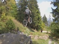
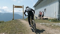
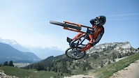
2,2km of pure flow, big berms, jumps, highspeed and naturals sections. This track has everything you could ask for even a 12m table jump.

If you are out of breath during your run, just stop and enjoy the magnificent view on the Diablerets glaciers, Dents du Midi or the iconic Tour D'AÏ, you won't be disappointed.

Photograper's paradise for sure

Access Info

Via telecabine La Berneuse.

Bike Park

Recent Activity on Trail

Past Week
  • 6 rides
  • 17 miles average
6 Months
  • 14 rides
  • 15 miles avg distance
All
  • 54 rides
  • Last: Jun 21, 2026
c1c2c3c4
January
February
March
April
May
June
July
August
September
October
November
December
update trails status or condition

Nérine - Upper... Trail Reports

statusdatedescription
Jun 20, 2026 @ 9:34am (Europe/Zurich)
3 days
Oct 3, 2025 @ 11:42am (Europe/Zurich)
Oct 3, 2025
Jul 12, 2025 @ 2:11pm
Jul 12, 2025
Pretty good
Aug 24, 2020 @ 4:50am
Aug 24, 2020
Undergraded; this is as hard as black runs I've ridden in other Alpine resorts. Road sections connect the singletrack. Caution parking in Leysin,...
Jul 25, 2020 @ 2:33am
Jul 25, 2020
more »
Status:
on Jun 20, 2026
Ideal
Avg: 3.99 (3 votes)
Your vote: 0

view (473)
close
3D
Trail Conditions
  • Unknown
  • Snow Groomed
  • Snow Packed
  • Snow Covered
  • Snow Cover Partial
  • Freeze/thaw Cycle
  • Icy
  • Prevalent Mud
  • Wet
  • Variable
  • Ideal
  • Dry
  • Very Dry
Trail Flow (Ridden Direction)
Trailforks scans users ridelogs to determine the most popular direction each trail is ridden. A good flowing trail network will have most trails flowing in a single direction according to their intension.
The colour categories are based on what percentage of riders are riding a trail in its intended direction.
  • > 96%
  • > 90%
  • > 80%
  • > 70%
  • > 50%
  • < 50%
  • bi-directional trail
  • no data
Trail Last Ridden
Trailforks scans ridelogs to determine the last time a trail was ridden.
  • < 2 days
  • < 1 week
  • < 2 weeks
  • < 1 month
  • < 6 months
  • > 6 months
Trail Ridden Direction
The intended direction a trail should be ridden.
  • Downhill Only
  • Downhill Primary
  • Both Directions
  • Uphill Primary
  • Uphill Only
  • One Direction
Contribute Details
Colors indicate trail is missing specified detail.
  • Description
  • Photos
  • Description & Photos
  • Videos
Trail Popularity ?
Trailforks scans ridelogs to determine which trails are ridden the most in the last 9 months. Trails are compared with nearby trails in the same city region with a possible 25 colour shades. Think of this as a heatmap, more rides = more kinetic energy = warmer colors.
  • most popular
  • popular
  • less popular
  • not popular
ATV/ORV/OHV Filter
Max Vehicle Width
inches
US Cell Coverage
Legend
cell carrier legend

Radar Time
Activity Recordings
Trailforks uses anonymized public activity data. ?
Activity Recordings
Trailforks uses anonymized public activity data. ?
Personal Heatmap
Activity Types
all / none
Options
2
Date range month
Winter Trails
Warning A routing network for winter maps does not exist. Selecting trails using the winter trails layer has been disabled.
Missing Trails
Most Popular
Least Popular
Trails are colored based on popularity. The more popular a trail is, the more red. Less popular trails trend towards green.
Jump Magnitude Heatmap
Heatmap of where riders jump on trails. Zoom in to see individual jumps, click circles to view jump details.
BC Backroad Status

Service Road Atlas is a free to use, community-driven service for viewing and creating reports on the numerous back-country service roads around B.C. and Alberta.

map legend
Slope Aspect
Direction the slope faces
Flat N NE E SE S SW W NW
Trails Deemphasized
Trails are shown in grey.
disable
Only show trails with no bike usage.
Enable
Suggested Layers
Based on selected activity type

    Save the current map location and zoom level as your default home location whenever this page is loaded.

    Save
        Directions to nerine-upper-section trailhead (46.365600, 7.016810)

        Photos

        41 more »
        121 |
        Jun 30, 2021 @ 12:13am
        Jun 30, 2021
        175 |
        Jun 30, 2021 @ 12:13am
        Jun 30, 2021
        85 |
        Jun 30, 2021 @ 12:13am
        Jun 30, 2021
        125 |
        Jun 30, 2021 @ 12:14am
        Jun 30, 2021

        Videos

        14 more »
        BikePark RAW 2018
        2:18 | 224 | Jul 28, 2019 , Leysin
        Swiss Downhill Championships 2021 - Leysin
        2:05 | 491 | Jul 26, 2021 , Leysin
        Swiss Downhill Championships 2021 - Leysin
        0:50 | 151 | Jun 29, 2021 , Leysin
        #HOMETRAILS - THE SHAPER: A mini documentary...
        4:16 | 118 | Jul 10, 2020 , Leysin

        Reviews / Comments

        No reviews yet, be the first to write a review or ask a question.
        Use trail reports to comment on trail conditions.


        We hope you've been enjoying Trailforks!

        Create a FREE account to view trail comments and much more.

        • By sebevoltage & contributors
        • #193506 - 1,547 views

        Frequently Asked Questions About Nérine - Upper section

        Where is Nérine - Upper section located?
        Nérine - Upper section is located in Leysin Bike Park, Leysin, Switzerland. It is part of the Leysin Bike Park trail network. The trailhead is located at coordinates 46.3656, 7.01681.
        How hard is Nérine - Upper section?
        Nérine - Upper section is rated as Red difficulty. The physical rating is Moderate. The average grade is 14.4%.
        What is the elevation gain for Nérine - Upper section?
        The trail has 171 m of elevation descent. The elevation ranges from 1,641 m to 1,812 m.
        How long is Nérine - Upper section?
        Nérine - Upper section is 1.2 km long. The trail type is machine groomed.

        Hit the Trail

        Open in App

        Get this trail on your phone instantly.
        open trail in app

        Download Trail

        Save to wishlist, Garmin & download.
        save the trail

        Find Related Routes

        Find routes and users activities that include this trail.
        find routes for this trail

        You must enter a description before submitting.