more stats
2,664 ft
Distance
-477 ft
Descent
00:06:14
Avg time
-477 ft
Altitude change
5,519 ft
Altitude min
5,997 ft
Altitude max
5,996 ft
Altitude start
5,518 ft
Altitude end
-17.9%
Grade
-80.7%
Grade max
0.6%
Grade min
135 ft
Distance climb
2,405 ft
Distance down
128 ft
Distance flat
00:06:14
Avg time

Neverwinter Details

  • Activities
    • Mountain Bike
    • E-Bike
    • Hike
    • Trail Running
    • Dirtbike/Moto
  • Riding Area
    Lake Mountains
    Eagle Mountain, Utah
  • Difficulty Rating
  • Local Popularity
    25 in Mountain Biking [+]
    • 40 in E-Biking
    • 65 in Trail Running
    • 5 in Hiking
    • 55 in Dirtbiking
  • Global Ranking
    #111690 in Mountain Biking [+]
    • #93770 in E-Biking
    • #97932 in Trail Running
    • #313830 in Hiking
    • #2692 in Dirtbiking
  • Trail Type
    Singletrack
  • Bike Type
    DH, AM
  • Direction
    Downhill Primary
  • Climb Difficulty
    Black Diamond
  • Physical Rating
    Hard
  • Trail Visibility
    Always easy to follow
  • Family Friendly
    Yes
  • Dogs Allowed
    Yes
  • eBike Allowed
    Yes up to Class 1
  • TTFs on Trail
    Rock Garden

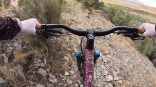
Not a climb-up trail. As a DH, many rock gardens, some nice rollable drops, and some steep sections Incredible views! If you want to make it double-black, hit the 15ft rollable rock face towards the bottom! Neverwinter because while most places are shutting down for the season, this area is actually best to ride in fall and on sunny winter days!

Disclaimer

Watch out for the 15ft rolllable rock face at the bottom! You can turn left to avoid it.

Traditionally Indigenous Territory

Recent Activity on Trail

Past Week
  • 0 rides
  •  
6 Months
  • 1 rides
  • 5 miles avg distance
All
  • 3 rides
  • Last: Mar 14, 2026
c1c2c3c4
January
February
March
April
May
June
July
August
September
October
November
December
update trails status or condition

Neverwinter Trail Reports

Status:
on Mar 14, 2026
Dry
Avg: 4.13 (2 votes)
Your vote: 0

view (41)
close
3D
Trail Conditions
  • Unknown
  • Snow Groomed
  • Snow Packed
  • Snow Covered
  • Snow Cover Partial
  • Freeze/thaw Cycle
  • Icy
  • Prevalent Mud
  • Wet
  • Variable
  • Ideal
  • Dry
  • Very Dry
Trail Flow (Ridden Direction)
Trailforks scans users ridelogs to determine the most popular direction each trail is ridden. A good flowing trail network will have most trails flowing in a single direction according to their intension.
The colour categories are based on what percentage of riders are riding a trail in its intended direction.
  • > 96%
  • > 90%
  • > 80%
  • > 70%
  • > 50%
  • < 50%
  • bi-directional trail
  • no data
Trail Last Ridden
Trailforks scans ridelogs to determine the last time a trail was ridden.
  • < 2 days
  • < 1 week
  • < 2 weeks
  • < 1 month
  • < 6 months
  • > 6 months
Trail Ridden Direction
The intended direction a trail should be ridden.
  • Downhill Only
  • Downhill Primary
  • Both Directions
  • Uphill Primary
  • Uphill Only
  • One Direction
Contribute Details
Colors indicate trail is missing specified detail.
  • Description
  • Photos
  • Description & Photos
  • Videos
Trail Popularity ?
Trailforks scans ridelogs to determine which trails are ridden the most in the last 9 months. Trails are compared with nearby trails in the same city region with a possible 25 colour shades. Think of this as a heatmap, more rides = more kinetic energy = warmer colors.
  • most popular
  • popular
  • less popular
  • not popular
ATV/ORV/OHV Filter
Max Vehicle Width
inches
US Cell Coverage
Legend
cell carrier legend

Radar Time
Activity Recordings
Trailforks uses anonymized public activity data. ?
Activity Recordings
Trailforks uses anonymized public activity data. ?
Personal Heatmap
Activity Types
all / none
Options
2
Date range month
Winter Trails
Warning A routing network for winter maps does not exist. Selecting trails using the winter trails layer has been disabled.
Missing Trails
Most Popular
Least Popular
Trails are colored based on popularity. The more popular a trail is, the more red. Less popular trails trend towards green.
Jump Magnitude Heatmap
Heatmap of where riders jump on trails. Zoom in to see individual jumps, click circles to view jump details.
BC Backroad Status

Service Road Atlas is a free to use, community-driven service for viewing and creating reports on the numerous back-country service roads around B.C. and Alberta.

map legend
Slope Aspect
Direction the slope faces
Flat N NE E SE S SW W NW
Trails Deemphasized
Trails are shown in grey.
disable
Only show trails with no bike usage.
Enable
Suggested Layers
Based on selected activity type

    Save the current map location and zoom level as your default home location whenever this page is loaded.

    Save
        Directions to neverwinter trailhead (40.265380, -111.970910)

        Photos

        10 more »
        61 |
        Nov 2, 2019 @ 11:32pm
        Nov 2, 2019
        55 |
        Nov 2, 2019 @ 11:32pm
        Nov 2, 2019
        60 |
        Nov 2, 2019 @ 11:32pm
        Nov 2, 2019
        52 |
        Nov 2, 2019 @ 11:32pm
        Nov 2, 2019

        Videos

        2 more »
        Neverwinter - Eagle Mtn, UT - MTB Trail Preview
        0:46 | 56 | Apr 25, 2025 , Eagle Mountain
        Neverwinter
        3:02 | 60 | Sep 27, 2024 , Eagle Mountain

        Routes with this trail

        6 miles 1,306 ft 14
        This is the recommended route to access Gravity Well. Climbs are mostly fire road at a manageable grade....

        2 Reviews & Comments


        We hope you've been enjoying Trailforks!

        Create a FREE account to view trail comments and much more.

        • By UtahLakeMountainsTF Pro & contributors
        • #232781 - 677 views

        Frequently Asked Questions About Neverwinter

        Where is Neverwinter located?
        Neverwinter is located in Lake Mountains, Eagle Mountain, Utah, United States. It is part of the Lake Mountains trail network. The trailhead is located at coordinates 40.26538, -111.97091.
        How hard is Neverwinter?
        Neverwinter is rated as Double Black Diamond difficulty. The physical rating is Hard. The average grade is 17.9%. The climb difficulty is rated Black Diamond.
        What is the elevation gain for Neverwinter?
        The trail has 477 ft of elevation descent. The elevation ranges from 5,519 ft to 5,997 ft.
        Is Neverwinter a point to point trail?
        Neverwinter is not a point to point trail. The direction is Downhill Primary. The trail type is singletrack.

        Hit the Trail

        Open in App

        Get this trail on your phone instantly.
        open trail in app

        Download Trail

        Save to wishlist, Garmin & download.
        save the trail

        Find Related Routes

        Find routes and users activities that include this trail.
        find routes for this trail

        You must enter a description before submitting.