more stats
3.2 miles
Distance
118 ft
Climb
-1,384 ft
Descent
1 mile
High Point
-1,263 ft
Altitude change
4,873 ft
Altitude min
6,197 ft
Altitude start
4,934 ft
Altitude end
-7.4%
Grade
-42.5%
Grade max
18.4%
Grade min
1,752 ft
Distance climb
3 miles
Distance down
1,312 ft
Distance flat

North Corner Details

  • Activities
    • Mountain Bike
    • E-Bike
  • Riding Area
    Black Mountain Trail Network
    Nordegg, Alberta
  • Ref Number
    #13
  • Difficulty Rating
  • Local Popularity
    95 in Mountain Biking [+]
    • 95 in E-Biking
  • Global Ranking
    #5143 in Mountain Biking
  • Trail Type
    Machine Groomed
  • Bike Type
    DH, AM, XC
  • Direction
    Downhill Only[+]
    Popular Direction Shown
    • Downhill Only for E-Biking
  • Physical Rating
    Moderate
  • Trail Visibility
    Always easy to follow
  • Dogs Allowed
    Yes
  • eBike Allowed
  • TTFs on Trail
    Berm, Bridge, Drop, Jump, Gap Jump, Rock Garden, Skinny, Wallride
  • Year Opened
    2025

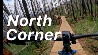
North Corner is a blue rated (More Difficult), tech-flow style trail. Notable trail features include: rollers, berms and optional gap jumps, drops, skinnies, and a wall ride.

When Martin Cohn moved to Canada, he changed his name to Martin Nordegg—roughly translated to “north corner” in German. Fitting name for a trail that kicks off at the summit and heads north, serving up adventure and beauty as you travel down and around the mountain.

Local Trail Association

Recent Activity on Trail

Past Week
  • 2 rides
  • 13 miles average
6 Months
  • 8 rides
  • 13 miles avg distance
All
  • 73 rides
  • Last: Jul 3, 2026
c1c2c3c4
January
February
March
April
May
June
July
August
September
October
November
December
update trails status or condition

North Corner Trail Reports

statusdatedescription
Jul 2, 2026 @ 10:13am (America/Edmonton)
Jul 2, 2026
Trails are drying up nicely however most have 1 or more small wet sections.
Jun 30, 2026 @ 3:55pm (America/Edmonton)
Jun 30, 2026
There has been significant rainfall on Black Mountain over the Jun 27 through July 1 weekend, Many trails are quite wet, some are drying up but...
Jun 5, 2026 @ 7:34am (America/Edmonton)
Jun 5, 2026
The section around the boardwalk has a lot of moisture and mud with water running across the trail. A closed sign is currently on it but might be...
May 29, 2026 @ 12:43pm (America/Edmonton)
May 29, 2026
Trail is open, a little muddy after the boardwalk. enjoy!
Apr 30, 2026 @ 9:24pm (America/Edmonton)
Apr 30, 2026
Walked around the mountain today on a few trails. (Skimmer, Razor Shades, Black Like Velvet, TPOC, Bambi, Makoons, Maskwa, Chaska, Magic Forest....
more »
Status:
on Jul 2, 2026
Variable
Avg: 4.29 (4 votes)
Your vote: 0

view (185)
close
3D
Trail Conditions
  • Unknown
  • Snow Groomed
  • Snow Packed
  • Snow Covered
  • Snow Cover Partial
  • Freeze/thaw Cycle
  • Icy
  • Prevalent Mud
  • Wet
  • Variable
  • Ideal
  • Dry
  • Very Dry
Trail Flow (Ridden Direction)
Trailforks scans users ridelogs to determine the most popular direction each trail is ridden. A good flowing trail network will have most trails flowing in a single direction according to their intension.
The colour categories are based on what percentage of riders are riding a trail in its intended direction.
  • > 96%
  • > 90%
  • > 80%
  • > 70%
  • > 50%
  • < 50%
  • bi-directional trail
  • no data
Trail Last Ridden
Trailforks scans ridelogs to determine the last time a trail was ridden.
  • < 2 days
  • < 1 week
  • < 2 weeks
  • < 1 month
  • < 6 months
  • > 6 months
Trail Ridden Direction
The intended direction a trail should be ridden.
  • Downhill Only
  • Downhill Primary
  • Both Directions
  • Uphill Primary
  • Uphill Only
  • One Direction
Contribute Details
Colors indicate trail is missing specified detail.
  • Description
  • Photos
  • Description & Photos
  • Videos
Trail Popularity ?
Trailforks scans ridelogs to determine which trails are ridden the most in the last 9 months. Trails are compared with nearby trails in the same city region with a possible 25 colour shades. Think of this as a heatmap, more rides = more kinetic energy = warmer colors.
  • most popular
  • popular
  • less popular
  • not popular
ATV/ORV/OHV Filter
Max Vehicle Width
inches
US Cell Coverage
Legend
cell carrier legend

Radar Time
Activity Recordings
Trailforks uses anonymized public activity data. ?
Activity Recordings
Trailforks uses anonymized public activity data. ?
Personal Heatmap
Activity Types
all / none
Options
2
Date range month
Winter Trails
Warning A routing network for winter maps does not exist. Selecting trails using the winter trails layer has been disabled.
Missing Trails
Most Popular
Least Popular
Trails are colored based on popularity. The more popular a trail is, the more red. Less popular trails trend towards green.
Jump Magnitude Heatmap
Heatmap of where riders jump on trails. Zoom in to see individual jumps, click circles to view jump details.
BC Backroad Status

Service Road Atlas is a free to use, community-driven service for viewing and creating reports on the numerous back-country service roads around B.C. and Alberta.

map legend
Slope Aspect
Direction the slope faces
Flat N NE E SE S SW W NW
Trails Deemphasized
Trails are shown in grey.
disable
Only show trails with no bike usage.
Enable
Suggested Layers
Based on selected activity type

    Save the current map location and zoom level as your default home location whenever this page is loaded.

    Save
        Directions to north-corner trailhead (52.460520, -116.267720)

        Photos

        11 more »
        62 |
        Oct 3, 2025 @ 11:19pm
        Oct 3, 2025
        150 |
        Jul 4, 2025 @ 9:38pm
        Jul 4, 2025
        150 |
        Jul 4, 2025 @ 9:38pm
        Jul 4, 2025
        134 |
        Jul 4, 2025 @ 9:38pm
        Jul 4, 2025

        Videos

        7 more »
        youtuber Black Mountain Trail Network: The North Corner...
        25:23 | 91 | Aug 11, 2025 , Nordegg
        North Corner
        14:06 | 432 | Jul 6, 2025 , Nordegg
        2 PoV’s with Ryan Gomonit
        3:41 | 67 | Jan 23, 2026 , Nordegg
        Follow Cam MalouPete
        2:18 | 28 | Jan 22, 2026 , Nordegg

        3 Reviews & Comments


        We hope you've been enjoying Trailforks!

        Create a FREE account to view trail comments and much more.

        • By Macvidal19TF Pro NORCA & contributors
        • #851101 - 762 views

        Frequently Asked Questions About North Corner

        Where is North Corner located?
        North Corner is located in Black Mountain Trail Network, Nordegg, Alberta, Canada. It is part of the Black Mountain Trail Network trail network. The trailhead is located at coordinates 52.46052, -116.26772.
        How hard is North Corner?
        North Corner is rated as Blue difficulty. The physical rating is Moderate. The average grade is 7.4%.
        What is the elevation gain for North Corner?
        North Corner has 36 m of elevation gain. The trail has 422 m of elevation descent. The elevation ranges from 1,485 m to 1,889 m.
        Is North Corner a point to point trail?
        Yes, North Corner is a point to point trail. The direction is Downhill Only. The trail type is machine groomed.

        Hit the Trail

        Open in App

        Get this trail on your phone instantly.
        open trail in app

        Download Trail

        Save to wishlist, Garmin & download.
        save the trail

        Find Related Routes

        Find routes and users activities that include this trail.
        find routes for this trail

        You must enter a description before submitting.