more stats
3,373 ft
Distance
88 ft
Climb
-173 ft
Descent
00:06:19
Avg time
-86 ft
Altitude change
1,752 ft
Altitude min
1,864 ft
Altitude max
1,838 ft
Altitude start
1,752 ft
Altitude end
-2.6%
Grade
-20.7%
Grade max
30.2%
Grade min
817 ft
Distance climb
2,205 ft
Distance down
354 ft
Distance flat
00:06:19
Avg time

North Leaf Details

  • Activities
    • Mountain Bike
    • Horse
    • Hike
    • Trail Running
  • Riding Area
    El Corte de Madera Creek Preserve
    Redwood City, California
  • Difficulty Rating
  • Voted Difficulty
    Black Diamond (1 vote)
  • Local Popularity
    80 in Mountain Biking [+]
    • 45 in Trail Running
    • 55 in Hiking
    • 5 in Horseback
  • Global Ranking
    #56581 in Mountain Biking [+]
    • #108129 in Trail Running
    • #91422 in Hiking
    • #1067 in Horseback
  • Trail Type
    Singletrack
  • Dogs Allowed
    Yes
  • eBike Allowed
  • Land Owner
    Midpeninsula Regional Open Space District

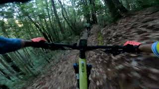
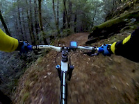
North Leaf is a narrow single track that has some technical sections. Right off the bat, there is a drop off of a root that could send an unwary beginner OTB. There are also some steep and rocky/rooty climbs that many may choose to walk. One section near the end of the trail squeezes you between a tree, some deep roots, and then dumps you out into a rocky drop. The end of the trail is the best - non-technical, very smooth, and fast

Local Trail Association
Traditionally Indigenous Territory

Recent Activity on Trail

Past Week
  • 4 rides
  • 13 miles average
6 Months
  • 117 rides
  • 15 miles avg distance
All
  • 1,449 rides
  • Last: Jun 3, 2026
c1c2c3c4
January
February
March
April
May
June
July
August
September
October
November
December
Status:
on Apr 8, 2026
Dry
Avg: 3.87 (17 votes)
Your vote: 0

view (7,768)
close
3D
Trail Conditions
  • Unknown
  • Snow Groomed
  • Snow Packed
  • Snow Covered
  • Snow Cover Partial
  • Freeze/thaw Cycle
  • Icy
  • Prevalent Mud
  • Wet
  • Variable
  • Ideal
  • Dry
  • Very Dry
Trail Flow (Ridden Direction)
Trailforks scans users ridelogs to determine the most popular direction each trail is ridden. A good flowing trail network will have most trails flowing in a single direction according to their intension.
The colour categories are based on what percentage of riders are riding a trail in its intended direction.
  • > 96%
  • > 90%
  • > 80%
  • > 70%
  • > 50%
  • < 50%
  • bi-directional trail
  • no data
Trail Last Ridden
Trailforks scans ridelogs to determine the last time a trail was ridden.
  • < 2 days
  • < 1 week
  • < 2 weeks
  • < 1 month
  • < 6 months
  • > 6 months
Trail Ridden Direction
The intended direction a trail should be ridden.
  • Downhill Only
  • Downhill Primary
  • Both Directions
  • Uphill Primary
  • Uphill Only
  • One Direction
Contribute Details
Colors indicate trail is missing specified detail.
  • Description
  • Photos
  • Description & Photos
  • Videos
Trail Popularity ?
Trailforks scans ridelogs to determine which trails are ridden the most in the last 9 months. Trails are compared with nearby trails in the same city region with a possible 25 colour shades. Think of this as a heatmap, more rides = more kinetic energy = warmer colors.
  • most popular
  • popular
  • less popular
  • not popular
ATV/ORV/OHV Filter
Max Vehicle Width
inches
US Cell Coverage
Legend
cell carrier legend

Radar Time
Activity Recordings
Trailforks uses anonymized public activity data. ?
Activity Recordings
Trailforks uses anonymized public activity data. ?
Personal Heatmap
Activity Types
all / none
Options
2
Date range month
Winter Trails
Warning A routing network for winter maps does not exist. Selecting trails using the winter trails layer has been disabled.
Missing Trails
Most Popular
Least Popular
Trails are colored based on popularity. The more popular a trail is, the more red. Less popular trails trend towards green.
Jump Magnitude Heatmap
Heatmap of where riders jump on trails. Zoom in to see individual jumps, click circles to view jump details.
BC Backroad Status

Service Road Atlas is a free to use, community-driven service for viewing and creating reports on the numerous back-country service roads around B.C. and Alberta.

map legend
Slope Aspect
Direction the slope faces
Flat N NE E SE S SW W NW
Trails Deemphasized
Trails are shown in grey.
disable
Only show trails with no bike usage.
Enable
Suggested Layers
Based on selected activity type

    Save the current map location and zoom level as your default home location whenever this page is loaded.

    Save
        Directions to north-leaf trailhead (37.408866, -122.332034)

        Photos

        7 more »
        422 |
        May 22, 2017 @ 1:24pm
        May 22, 2017
        37 |
        Jun 17, 2025 @ 2:22pm
        Jun 17, 2025
        56 |
        Apr 15, 2023 @ 3:31pm
        Apr 15, 2023
        57 |
        Mar 27, 2023 @ 4:27pm
        Mar 27, 2023

        Videos

        3 more »
        Corte de Madera - North Leaf DH
        0:14 | 247 | Oct 30, 2023 , Redwood City
        El Corte de Madera Creek and North Leaf
        16:33 | 212 | May 25, 2023 , Redwood City
        Skeggs Point MTB (North Leaf Trail Descent)
        3:25 | 672 | Dec 8, 2013 , Redwood City

        Routes with this trail

        4.4 10 miles 2,379 ft 5
        Skegg's Point 7 in El Corte de Madera Creek Open Space Preserve
        4.5 19 miles 4,269 ft 10 Loop
        Big loop from Star Hill parking, hitting , , , , and
        4.0 18 miles 4,897 ft 9

        7 Reviews & Comments


        We hope you've been enjoying Trailforks!

        Create a FREE account to view trail comments and much more.

        Frequently Asked Questions About North Leaf

        Where is North Leaf located?
        North Leaf is located in El Corte de Madera Creek Preserve, Redwood City, California, United States. It is part of the El Corte de Madera Creek Preserve trail network. The trailhead is located at coordinates 37.40887, -122.33203.
        How hard is North Leaf?
        North Leaf is rated as Blue difficulty. The average grade is 2.6%.
        What is the elevation gain for North Leaf?
        North Leaf has 88 ft of elevation gain. The trail has 173 ft of elevation descent. The elevation ranges from 1,752 ft to 1,864 ft.
        How long is North Leaf?
        North Leaf is 3,373 ft long. The trail type is singletrack.

        Hit the Trail

        Open in App

        Get this trail on your phone instantly.
        open trail in app

        Download Trail

        Save to wishlist, Garmin & download.
        save the trail

        Find Related Routes

        Find routes and users activities that include this trail.
        find routes for this trail

        You must enter a description before submitting.