more stats
2.1 miles
Distance
187 ft
Climb
-179 ft
Descent
00:14:49
Avg time
9 ft
Altitude change
538 ft
Altitude min
605 ft
Altitude max
569 ft
Altitude start
577 ft
Altitude end
0.1%
Grade
-23.1%
Grade max
30.9%
Grade min
2,687 ft
Distance climb
2,651 ft
Distance down
1 mile
Distance flat
00:14:49
Avg time

Northshore Loop 4 Details

  • Activities
    • Mountain Bike
    • E-Bike
    • Hike
    • Trail Running
  • Riding Area
    Northshore
    Flower Mound, Texas
  • Difficulty Rating
  • Voted Difficulty
    Blue (6 votes)
  • Local Popularity
    90 in Mountain Biking [+]
    • 100 in E-Biking
    • 100 in Trail Running
    • 100 in Hiking
  • Global Ranking
    #1838 in Mountain Biking [+]
    • #33392 in Trail Running
    • #12196 in Hiking
  • Hiking SAC Scale
    T1 Hiking
  • Trail Type
    Singletrack
  • Bike Type
    XC
  • Direction
    One Direction
    Popular Direction Shown
  • Climb Difficulty
    Green
  • Physical Rating
    Easy
  • Dogs Allowed
    Yes
  • eBike Allowed
  • TTFs on Trail
    Berm, Bridge, Jump, Rock Face

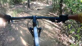
The east side of Northshore is fairly easy but a lot of fun. This is DFW's most popular trail so be prepared for my riders, joggers, and walkers on the weekend. It is very well marked with plenty of parking. Not many climbs and only 2 or 3 semi-tricky rock sections.

Disclaimer

Ebikes are allowed, but a permit must be obtained. There are some restrictions on who can get one. Please see the link on the main page "Ebike Policy and Blank Permit Form" for more information.

Local Trail Association
Traditionally Indigenous Territory

Recent Activity on Trail

Past Week
  • 31 rides
  • 18 miles average
6 Months
  • 536 rides
  • 14 miles avg distance
All
  • 3,005 rides
  • Last: Jul 3, 2026
c1c2c3c4
January
February
March
April
May
June
July
August
September
October
November
December
Status:
on Jun 21, 2026
Variable
Avg: 4.22 (21 votes)
Your vote: 0

view (23,143)
close
3D
Trail Conditions
  • Unknown
  • Snow Groomed
  • Snow Packed
  • Snow Covered
  • Snow Cover Partial
  • Freeze/thaw Cycle
  • Icy
  • Prevalent Mud
  • Wet
  • Variable
  • Ideal
  • Dry
  • Very Dry
Trail Flow (Ridden Direction)
Trailforks scans users ridelogs to determine the most popular direction each trail is ridden. A good flowing trail network will have most trails flowing in a single direction according to their intension.
The colour categories are based on what percentage of riders are riding a trail in its intended direction.
  • > 96%
  • > 90%
  • > 80%
  • > 70%
  • > 50%
  • < 50%
  • bi-directional trail
  • no data
Trail Last Ridden
Trailforks scans ridelogs to determine the last time a trail was ridden.
  • < 2 days
  • < 1 week
  • < 2 weeks
  • < 1 month
  • < 6 months
  • > 6 months
Trail Ridden Direction
The intended direction a trail should be ridden.
  • Downhill Only
  • Downhill Primary
  • Both Directions
  • Uphill Primary
  • Uphill Only
  • One Direction
Contribute Details
Colors indicate trail is missing specified detail.
  • Description
  • Photos
  • Description & Photos
  • Videos
Trail Popularity ?
Trailforks scans ridelogs to determine which trails are ridden the most in the last 9 months. Trails are compared with nearby trails in the same city region with a possible 25 colour shades. Think of this as a heatmap, more rides = more kinetic energy = warmer colors.
  • most popular
  • popular
  • less popular
  • not popular
ATV/ORV/OHV Filter
Max Vehicle Width
inches
US Cell Coverage
Legend
cell carrier legend

Radar Time
Activity Recordings
Trailforks uses anonymized public activity data. ?
Activity Recordings
Trailforks uses anonymized public activity data. ?
Personal Heatmap
Activity Types
all / none
Options
2
Date range month
Winter Trails
Warning A routing network for winter maps does not exist. Selecting trails using the winter trails layer has been disabled.
Missing Trails
Most Popular
Least Popular
Trails are colored based on popularity. The more popular a trail is, the more red. Less popular trails trend towards green.
Jump Magnitude Heatmap
Heatmap of where riders jump on trails. Zoom in to see individual jumps, click circles to view jump details.
BC Backroad Status

Service Road Atlas is a free to use, community-driven service for viewing and creating reports on the numerous back-country service roads around B.C. and Alberta.

map legend
Slope Aspect
Direction the slope faces
Flat N NE E SE S SW W NW
Trails Deemphasized
Trails are shown in grey.
disable
Only show trails with no bike usage.
Enable
Suggested Layers
Based on selected activity type

    Save the current map location and zoom level as your default home location whenever this page is loaded.

    Save
        Directions to northshore-loop-4 trailhead (32.991560, -97.075120)

        Photos

        61 more »
        371 |
        Jul 15, 2024 @ 7:07am
        Jul 15, 2024
        543 |
        Jul 15, 2024 @ 7:07am
        Jul 15, 2024
        309 |
        Jul 15, 2024 @ 7:07am
        Jul 15, 2024
        307 |
        Jul 15, 2024 @ 7:07am
        Jul 15, 2024

        Videos

        8 more »
        Loop 4 | Northshore Full Trail Mountain Biking DFW
        14:12 | 373 | Oct 7, 2023 , Flower Mound
        Northshore Trail Loops 1-4 | Flower Mound, Texas
        15:34 | 541 | Jul 25, 2023 , Flower Mound
        Rockledge Park TTF
        0:22 | 480 | Aug 15, 2021 , Flower Mound
        Nice flow before pit drop
        0:59 | 614 | Aug 15, 2021 , Flower Mound

        Routes with this trail

        2.5 11 miles 845 ft 3 Loop
        Northshore loops 1-4 (blue) from the MADD shelter and back
        3.5 11 miles 569 ft 12 Out & Back
        Northshore ride of the less technical loops.
        19 miles 1,095 ft 6
        this is a full lap MADD start West + East

        2 Reviews & Comments


        We hope you've been enjoying Trailforks!

        Create a FREE account to view trail comments and much more.

        • By toddTF Pro Trailforks & contributors
        • #15724 - 14,112 views

        Frequently Asked Questions About Northshore Loop 4

        Where is Northshore Loop 4 located?
        Northshore Loop 4 is located in Northshore, Flower Mound, Texas, United States. It is part of the Northshore trail network. The trailhead is located at coordinates 32.99156, -97.07512.
        How hard is Northshore Loop 4?
        Northshore Loop 4 is rated as Blue difficulty. The physical rating is Easy. The average grade is 0.1%. The climb difficulty is rated Green.
        What is the elevation gain for Northshore Loop 4?
        Northshore Loop 4 has 187 ft of elevation gain. The trail has 179 ft of elevation descent. The elevation ranges from 538 ft to 605 ft.
        Is Northshore Loop 4 a point to point trail?
        Yes, Northshore Loop 4 is a point to point trail. The direction is One Direction. The trail type is singletrack.

        Hit the Trail

        Open in App

        Get this trail on your phone instantly.
        open trail in app

        Download Trail

        Save to wishlist, Garmin & download.
        save the trail

        Find Related Routes

        Find routes and users activities that include this trail.
        find routes for this trail

        You must enter a description before submitting.