more stats
1.6 miles
Distance
3 ft
Climb
-545 ft
Descent
00:10:42
Avg time
-543 ft
Altitude change
7,133 ft
Altitude min
7,676 ft
Altitude max
7,676 ft
Altitude start
7,133 ft
Altitude end
-6.4%
Grade
-20.5%
Grade max
2.2%
Grade min
154 ft
Distance climb
2 miles
Distance down
177 ft
Distance flat
00:10:42
Avg time

NPR Details

  • Activities
    • Mountain Bike
  • Riding Area
    Emerald Mountain
    Steamboat Springs, Colorado
  • Difficulty Rating
  • Voted Difficulty
    Blue (3 votes)
  • Local Popularity
    100 in Mountain Biking
  • Global Ranking
    #18433 in Mountain Biking
  • Trail Type
    Singletrack
  • Bike Type
    DH
  • Direction
    Downhill Only
    Popular Direction Shown
  • Dogs Allowed
    Yes
  • eBike Allowed
  • TTFs on Trail
    Bridge, Jump
  • Year Opened
    2015
  • Land Owner

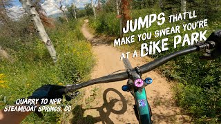
Fun flowy downhill trail. Lots of berms and table top jumps. All the jumps are beginner friendly and are easy to ride over if you don't want to jump them. Very smooth trail, rocks are almost not existent, until the very bottom section.

Local Trail Association
Traditionally Indigenous Territory

Recent Activity on Trail

Past Week
  • 19 rides
  • 13 miles average
6 Months
  • 103 rides
  • 12 miles avg distance
All
  • 1,291 rides
  • Last: Jun 15, 2026
c1c2c3c4
January
February
March
April
May
June
July
August
September
October
November
December
Status:
on May 29, 2026
Variable
Avg: 4.58 (19 votes)
Your vote: 0

view (7,049)
close
3D
Trail Conditions
  • Unknown
  • Snow Groomed
  • Snow Packed
  • Snow Covered
  • Snow Cover Partial
  • Freeze/thaw Cycle
  • Icy
  • Prevalent Mud
  • Wet
  • Variable
  • Ideal
  • Dry
  • Very Dry
Trail Flow (Ridden Direction)
Trailforks scans users ridelogs to determine the most popular direction each trail is ridden. A good flowing trail network will have most trails flowing in a single direction according to their intension.
The colour categories are based on what percentage of riders are riding a trail in its intended direction.
  • > 96%
  • > 90%
  • > 80%
  • > 70%
  • > 50%
  • < 50%
  • bi-directional trail
  • no data
Trail Last Ridden
Trailforks scans ridelogs to determine the last time a trail was ridden.
  • < 2 days
  • < 1 week
  • < 2 weeks
  • < 1 month
  • < 6 months
  • > 6 months
Trail Ridden Direction
The intended direction a trail should be ridden.
  • Downhill Only
  • Downhill Primary
  • Both Directions
  • Uphill Primary
  • Uphill Only
  • One Direction
Contribute Details
Colors indicate trail is missing specified detail.
  • Description
  • Photos
  • Description & Photos
  • Videos
Trail Popularity ?
Trailforks scans ridelogs to determine which trails are ridden the most in the last 9 months. Trails are compared with nearby trails in the same city region with a possible 25 colour shades. Think of this as a heatmap, more rides = more kinetic energy = warmer colors.
  • most popular
  • popular
  • less popular
  • not popular
ATV/ORV/OHV Filter
Max Vehicle Width
inches
US Cell Coverage
Legend
cell carrier legend

Radar Time
Activity Recordings
Trailforks uses anonymized public activity data. ?
Activity Recordings
Trailforks uses anonymized public activity data. ?
Personal Heatmap
Activity Types
all / none
Options
2
Date range month
Winter Trails
Warning A routing network for winter maps does not exist. Selecting trails using the winter trails layer has been disabled.
Missing Trails
Most Popular
Least Popular
Trails are colored based on popularity. The more popular a trail is, the more red. Less popular trails trend towards green.
Jump Magnitude Heatmap
Heatmap of where riders jump on trails. Zoom in to see individual jumps, click circles to view jump details.
BC Backroad Status

Service Road Atlas is a free to use, community-driven service for viewing and creating reports on the numerous back-country service roads around B.C. and Alberta.

map legend
Slope Aspect
Direction the slope faces
Flat N NE E SE S SW W NW
Trails Deemphasized
Trails are shown in grey.
disable
Only show trails with no bike usage.
Enable
Suggested Layers
Based on selected activity type

    Save the current map location and zoom level as your default home location whenever this page is loaded.

    Save
        Directions to npr trailhead (40.465680, -106.842410)

        Photos

        166 more »
        460 |
        Jan 23, 2018 @ 8:00pm
        Jan 23, 2018
        247 |
        Mar 2, 2016 @ 7:31pm
        Mar 2, 2016
        207 |
        Jun 21, 2019 @ 6:58am
        Jun 21, 2019
        78 |
        May 27, 2019 @ 6:18pm
        May 27, 2019

        Videos

        6 more »
        Blew Out my Tube on NPR @ Emerald Mountain
        24:05 | 111 | Jul 27, 2025 , Steamboat Springs
        NPR MTB Trail Steamboat Springs CO
        6:09 | 178 | Jul 22, 2023 , Steamboat Springs
        No Pedaling Required (NPR) Trail Steamboat - 5...
        13:03 | 320 | Jan 29, 2023 , Steamboat Springs
        Bike Park Quality Jumps on Emerald Mountain:...
        8:48 | 184 | Dec 2, 2022 , Steamboat Springs

        Routes with this trail

        4.0 11 miles 1,797 ft 46
        Town Challenge Emerald Sport route July 26
        19 miles 2,820 ft 56
        Town Challenge Pro Course September 16
        13 miles 2,156 ft 51
        Town Challenge Emerald. pro course, july 26

        5 Reviews & Comments


        We hope you've been enjoying Trailforks!

        Create a FREE account to view trail comments and much more.

        • By ewmeyerTF Pro & contributors
        • #35746 - 7,205 views

        Frequently Asked Questions About NPR

        Where is NPR located?
        NPR is located in Emerald Mountain, Steamboat Springs, Colorado, United States. It is part of the Emerald Mountain trail network. The trailhead is located at coordinates 40.46568, -106.84241.
        How hard is NPR?
        NPR is rated as Blue difficulty. The average grade is 6.4%.
        What is the elevation gain for NPR?
        NPR has 3 ft of elevation gain. The trail has 545 ft of elevation descent. The elevation ranges from 7,133 ft to 7,676 ft.
        Is NPR a point to point trail?
        Yes, NPR is a point to point trail. The direction is Downhill Only. The trail type is singletrack.

        Hit the Trail

        Open in App

        Get this trail on your phone instantly.
        open trail in app

        Download Trail

        Save to wishlist, Garmin & download.
        save the trail

        Find Related Routes

        Find routes and users activities that include this trail.
        find routes for this trail

        You must enter a description before submitting.