more stats
627 ft
Distance
-173 ft
Descent
00:02:48
Avg time
-173 ft
Altitude change
2,311 ft
Altitude min
2,484 ft
Altitude max
2,484 ft
Altitude start
2,310 ft
Altitude end
-27.6%
Grade
-54.3%
Grade max
564 ft
Distance down
59 ft
Distance flat
00:02:48
Avg time

Orbit Details

  • Activities
    • Mountain Bike
  • Riding Area
  • Difficulty Rating
  • Voted Difficulty
    Double Black Diamond (1 vote)
  • Local Popularity
    70 in Mountain Biking
  • Global Ranking
    #58036 in Mountain Biking
  • Trail Type
    Singletrack
  • Bike Type
    DH, AM
  • Direction
    Downhill Primary
    Popular Direction Shown
  • Trail Visibility
    Always easy to follow
  • TTFs on Trail
    Berm, Drop, Jump
  • Land Owner
    MBP

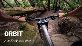
This spicy little trail departs from the lower Marriott’s / King Brown junction and features an infamous, extremely technical chute/drop. This double black diamond trail is definitely suitable for advanced riders only

Bike Park

Local Trail Association
  • trail association logo
  • Please consider joining or donating to the local trail association to support
    trail development & maintenance.
Traditionally Indigenous Territory

Recent Activity on Trail

Past Week
  • 0 rides
  •  
6 Months
  • 55 rides
  • 18 miles avg distance
All
  • 228 rides
  • Last: May 29, 2026
c1c2c3c4
January
February
March
April
May
June
July
August
September
October
November
December
update trails status or condition

Orbit Trail Reports

statusdatedescription
Oct 10, 2024 @ 3:14am
Oct 10, 2024
reporter
Sep 27, 2024 @ 7:13pm
Sep 27, 2024
reporter Requires Clearing after winter closure
Sep 27, 2024 @ 10:03am
Sep 27, 2024
May 26, 2024 @ 4:31pm
May 26, 2024
reporter Closed for the winter. Reopening Sep 28th
more »
Status:
on Oct 10, 2024
Avg: 4.09 (5 votes)
Your vote: 0

view (2,636)
close
3D
Trail Conditions
  • Unknown
  • Snow Groomed
  • Snow Packed
  • Snow Covered
  • Snow Cover Partial
  • Freeze/thaw Cycle
  • Icy
  • Prevalent Mud
  • Wet
  • Variable
  • Ideal
  • Dry
  • Very Dry
Trail Flow (Ridden Direction)
Trailforks scans users ridelogs to determine the most popular direction each trail is ridden. A good flowing trail network will have most trails flowing in a single direction according to their intension.
The colour categories are based on what percentage of riders are riding a trail in its intended direction.
  • > 96%
  • > 90%
  • > 80%
  • > 70%
  • > 50%
  • < 50%
  • bi-directional trail
  • no data
Trail Last Ridden
Trailforks scans ridelogs to determine the last time a trail was ridden.
  • < 2 days
  • < 1 week
  • < 2 weeks
  • < 1 month
  • < 6 months
  • > 6 months
Trail Ridden Direction
The intended direction a trail should be ridden.
  • Downhill Only
  • Downhill Primary
  • Both Directions
  • Uphill Primary
  • Uphill Only
  • One Direction
Contribute Details
Colors indicate trail is missing specified detail.
  • Description
  • Photos
  • Description & Photos
  • Videos
Trail Popularity ?
Trailforks scans ridelogs to determine which trails are ridden the most in the last 9 months. Trails are compared with nearby trails in the same city region with a possible 25 colour shades. Think of this as a heatmap, more rides = more kinetic energy = warmer colors.
  • most popular
  • popular
  • less popular
  • not popular
ATV/ORV/OHV Filter
Max Vehicle Width
inches
US Cell Coverage
Legend
cell carrier legend

Radar Time
Activity Recordings
Trailforks uses anonymized public activity data. ?
Activity Recordings
Trailforks uses anonymized public activity data. ?
Personal Heatmap
Activity Types
all / none
Options
2
Date range month
Winter Trails
Warning A routing network for winter maps does not exist. Selecting trails using the winter trails layer has been disabled.
Missing Trails
Most Popular
Least Popular
Trails are colored based on popularity. The more popular a trail is, the more red. Less popular trails trend towards green.
Jump Magnitude Heatmap
Heatmap of where riders jump on trails. Zoom in to see individual jumps, click circles to view jump details.
BC Backroad Status

Service Road Atlas is a free to use, community-driven service for viewing and creating reports on the numerous back-country service roads around B.C. and Alberta.

map legend
Slope Aspect
Direction the slope faces
Flat N NE E SE S SW W NW
Trails Deemphasized
Trails are shown in grey.
disable
Only show trails with no bike usage.
Enable
Suggested Layers
Based on selected activity type

    Save the current map location and zoom level as your default home location whenever this page is loaded.

    Save
        Directions to orbit trailhead (-42.771710, 146.641330)

        Photos

        3 more »
        48 |
        Mar 3, 2024 @ 10:36pm
        Mar 3, 2024
        78 |
        Feb 20, 2021 @ 5:13pm
        Feb 20, 2021
        472 |
        Feb 10, 2019 @ 10:10pm
        Feb 10, 2019

        Videos

        1 more »
        Orbit | Maydena Bike Park Trail of the Week
        0:00 | 124 | Mar 3, 2024 , Maydena

        Trail Lists

        Routes with this trail

        34 miles 9,473 ft 43 Loop
        In March 2023, the inaugural UCI Enduro World Cup and Enduro of Maydena will take place in Tasmania...
        34 miles 9,473 ft 43 Loop Race
        In March 2023, the inaugural UCI Enduro World Cup and Enduro of Maydena will take place in Tasmania...

        1 Review & Comments


        We hope you've been enjoying Trailforks!

        Create a FREE account to view trail comments and much more.

        • By mjjrTF Pro & contributors
        • #238046 - 793 views

        Frequently Asked Questions About Orbit

        Where is Orbit located?
        Orbit is located in Maydena Bike Park, Maydena, Australia. It is part of the Maydena Bike Park trail network. The trailhead is located at coordinates -42.77171, 146.64133.
        How hard is Orbit?
        Orbit is rated as Double Black Diamond difficulty. The average grade is 27.6%.
        What is the elevation gain for Orbit?
        The trail has 53 m of elevation descent. The elevation ranges from 704 m to 757 m.
        Is Orbit a point to point trail?
        Orbit is not a point to point trail. The direction is Downhill Primary. The trail type is singletrack.

        Hit the Trail

        Open in App

        Get this trail on your phone instantly.
        open trail in app

        Download Trail

        Save to wishlist, Garmin & download.
        save the trail

        Find Related Routes

        Find routes and users activities that include this trail.
        find routes for this trail

        You must enter a description before submitting.