more stats
1.1 miles
Distance
-931 ft
Descent
00:09:16
Avg time
-931 ft
Altitude change
2,057 ft
Altitude min
2,988 ft
Altitude max
2,988 ft
Altitude start
2,057 ft
Altitude end
-16.8%
Grade
-47.1%
Grade max
-3.6%
Grade min
1 mile
Distance down
00:09:16
Avg time

Orgasmatron Details

  • Activities
    • Mountain Bike
    • E-Bike
  • Riding Area
    Chortiatis
    Thessaloniki
  • Difficulty Rating
  • Voted Difficulty
    Black Diamond (1 vote)
  • Local Popularity
    65 in Mountain Biking [+]
    • 70 in E-Biking
  • Global Ranking
    #100883 in Mountain Biking [+]
    • #62999 in E-Biking
  • Trail Type
    Singletrack
  • Bike Type
    DH, AM
  • Direction
    Downhill Primary
    Popular Direction Shown
  • Climb Difficulty
    Double Black Diamond
  • Physical Rating
    Hard
  • Trail Visibility
    Sometimes hard to follow
  • Dogs Allowed
    Yes
  • eBike Allowed
    Yes up to Class 1
  • TTFs on Trail
    Berm, Drop, Jump, Gap Jump, Ladder Bridge, Rock Face, Rock Garden

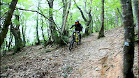
Orgasmatron, single black trail, it's fist part has nice natural flow with lots of features including drops and step-up jumps. It's second part is rocky, a little steep and technical. Should be avoided during Autumn months because it is covered with leafs.

Local Trail Association

Recent Activity on Trail

Past Week
  • 0 rides
  •  
6 Months
  • 5 rides
  • 28 miles avg distance
All
  • 14 rides
  • Last: Jun 12, 2026
c1c2c3c4
January
February
March
April
May
June
July
August
September
October
November
December
update trails status or condition

Orgasmatron Trail Reports

statusdatedescription
Apr 5, 2025 @ 10:36am
Apr 5, 2025
Small tree down across trail, can navigate over or around
Jul 2, 2024 @ 7:11am
Jul 2, 2024
very dry and slippery
Jun 30, 2023 @ 5:16am
Jun 30, 2023
Κάποιες νεροφαγιές θέλουν ιδιαίτερη προσοχή λόγο των τελευταίων βροχών, ιδίως...
Jun 9, 2023 @ 1:48pm
Jun 9, 2023
Jun 4, 2021 @ 10:38pm
Jun 4, 2021
more »
Status:
on Apr 5, 2025
Prevalent Mud
Avg: 4.1 (3 votes)
Your vote: 0

view (150)
close
3D
Trail Conditions
  • Unknown
  • Snow Groomed
  • Snow Packed
  • Snow Covered
  • Snow Cover Partial
  • Freeze/thaw Cycle
  • Icy
  • Prevalent Mud
  • Wet
  • Variable
  • Ideal
  • Dry
  • Very Dry
Trail Flow (Ridden Direction)
Trailforks scans users ridelogs to determine the most popular direction each trail is ridden. A good flowing trail network will have most trails flowing in a single direction according to their intension.
The colour categories are based on what percentage of riders are riding a trail in its intended direction.
  • > 96%
  • > 90%
  • > 80%
  • > 70%
  • > 50%
  • < 50%
  • bi-directional trail
  • no data
Trail Last Ridden
Trailforks scans ridelogs to determine the last time a trail was ridden.
  • < 2 days
  • < 1 week
  • < 2 weeks
  • < 1 month
  • < 6 months
  • > 6 months
Trail Ridden Direction
The intended direction a trail should be ridden.
  • Downhill Only
  • Downhill Primary
  • Both Directions
  • Uphill Primary
  • Uphill Only
  • One Direction
Contribute Details
Colors indicate trail is missing specified detail.
  • Description
  • Photos
  • Description & Photos
  • Videos
Trail Popularity ?
Trailforks scans ridelogs to determine which trails are ridden the most in the last 9 months. Trails are compared with nearby trails in the same city region with a possible 25 colour shades. Think of this as a heatmap, more rides = more kinetic energy = warmer colors.
  • most popular
  • popular
  • less popular
  • not popular
ATV/ORV/OHV Filter
Max Vehicle Width
inches
US Cell Coverage
Legend
cell carrier legend

Radar Time
Activity Recordings
Trailforks uses anonymized public activity data. ?
Activity Recordings
Trailforks uses anonymized public activity data. ?
Personal Heatmap
Activity Types
all / none
Options
2
Date range month
Winter Trails
Warning A routing network for winter maps does not exist. Selecting trails using the winter trails layer has been disabled.
Missing Trails
Most Popular
Least Popular
Trails are colored based on popularity. The more popular a trail is, the more red. Less popular trails trend towards green.
Jump Magnitude Heatmap
Heatmap of where riders jump on trails. Zoom in to see individual jumps, click circles to view jump details.
BC Backroad Status

Service Road Atlas is a free to use, community-driven service for viewing and creating reports on the numerous back-country service roads around B.C. and Alberta.

map legend
Slope Aspect
Direction the slope faces
Flat N NE E SE S SW W NW
Trails Deemphasized
Trails are shown in grey.
disable
Only show trails with no bike usage.
Enable
Suggested Layers
Based on selected activity type

    Save the current map location and zoom level as your default home location whenever this page is loaded.

    Save
        Directions to orgasmatron trailhead (40.596490, 23.116480)

        Photos

        6 more »
        92 |
        May 23, 2022 @ 9:25am
        May 23, 2022
        86 |
        May 23, 2022 @ 9:25am
        May 23, 2022
        78 |
        May 23, 2022 @ 9:25am
        May 23, 2022
        102 |
        May 23, 2022 @ 9:25am
        May 23, 2022

        Videos

        2 more »
        One Day Pass at Chortiatis MT
        2:22 | 175 | Jul 18, 2021 , Thessaloniki
        Riding over the town
        0:56 | 433 | Oct 10, 2018 , Thessaloniki

        1 Review & Comments


        We hope you've been enjoying Trailforks!

        Create a FREE account to view trail comments and much more.

        • By mtbrgr & contributors
        • #71698 - 2,362 views

        Frequently Asked Questions About Orgasmatron

        Where is Orgasmatron located?
        Orgasmatron is located in Chortiatis, Thessaloniki, Greece. It is part of the Chortiatis trail network. The trailhead is located at coordinates 40.59649, 23.11648.
        How hard is Orgasmatron?
        Orgasmatron is rated as Black Diamond difficulty. The physical rating is Hard. The average grade is 16.8%. The climb difficulty is rated Double Black Diamond.
        What is the elevation gain for Orgasmatron?
        The trail has 931 ft of elevation descent. The elevation ranges from 2,057 ft to 2,988 ft.
        Is Orgasmatron a point to point trail?
        Orgasmatron is not a point to point trail. The direction is Downhill Primary. The trail type is singletrack.

        Hit the Trail

        Open in App

        Get this trail on your phone instantly.
        open trail in app

        Download Trail

        Save to wishlist, Garmin & download.
        save the trail

        Find Related Routes

        Find routes and users activities that include this trail.
        find routes for this trail

        You must enter a description before submitting.