6.1 miles
Distance
1,235 ft
Climb
-1,136 ft
Descent
00:55:51
Avg time

Outer Loop Details

  • Activities
    • Mountain Bike
    • Hike
    • Trail Running
  • Riding Area
  • Difficulty Rating
  • Trail Type
    Singletrack
  • Bike Type
    XC
  • Direction
    Both Directions
  • Climb Difficulty
    Blue
  • Physical Rating
    Moderate
  • Family Friendly
    Yes
  • Dogs Allowed
    Yes
  • TTFs on Trail
    Berm, Other
  • Global Ranking
    #47641 in Mountain Biking [+]
    • #63748 in Hiking
  • Local Popularity
    100 in Mountain Biking [+]
    • 90 in Trail Running
    • 95 in Hiking
  • Year Opened
    2011
  • Land Owner
    Alaska Dept of Natural Resources - MLW

A singletrack flow trail that is very swoopy.

Short closure during spring break-up.
Dogs: Leashed
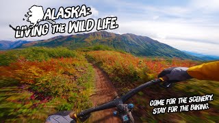
The Outer Loop is the longest trail of the Ester Dome Singletrack Happy Valley Trail System. Snaking its way around a forested loop on a south-facing hillside, this trail strikes a balance between winding forest singletrack and bermed-earth "bike-park" features. Similar in design to the Inner Loop, the trail bed is smooth and everything is do-able for a biker with intermediate skills. The trail runs mostly through open aspen forest with occasional forays into denser stands of mixed spruce and birch. Lots of squirrels and songbirds in the area, but especially keep watch for the occasional moose.

Take care at the intersections, as there are several. Look for the signs and colored reflectors (Inner Loop = Yellow, Outer Loop = Orange, TnT = Green). The Inner Loop and Outer Loop meet three times, the Equinox Marathon Trail crosses over the easternmost end of the Outer Loop, and the Henderson Drop-In meets the trail near its highest and westernmost point.

Access Info

Trailhead & parking, 1.6 mile Ester Dome Road.

Local Trail Association
  • trail association logo
  • Please consider joining or donating to the local trail association to support
    trail development & maintenance.
Traditionally Indigenous Territory
More Stats for Outer Loop mountain bike trail trail
  • Altitude change
    99 ft
  • Altitude min
    837 ft
  • Altitude max
    1,487 ft
  • Altitude start
    1,174 ft
  • Altitude end
    1,273 ft
  • Grade
    0.308%
  • Grade max
    -25.033%
  • Grade min
    21.86%
  • Distance climb
    3 miles
  • Distance down
    3 miles
  • Distance flat
    4,173 ft
  • Avg time
    00:55:51
  • Avg reverse time
    01:00:12
  • view trail stats
Status:
on Feb 3, 2025
Prevalent Mud
Avg: 4.31 (10 votes)
Your vote: 0

view (341)
close
3D
Trail Conditions
  • Unknown
  • Snow Groomed
  • Snow Packed
  • Snow Covered
  • Snow Cover Partial
  • Freeze/thaw Cycle
  • Icy
  • Prevalent Mud
  • Wet
  • Variable
  • Ideal
  • Dry
  • Very Dry
Trail Flow (Ridden Direction)
Trailforks scans users ridelogs to determine the most popular direction each trail is ridden. A good flowing trail network will have most trails flowing in a single direction according to their intension.
The colour categories are based on what percentage of riders are riding a trail in its intended direction.
  • > 96%
  • > 90%
  • > 80%
  • > 70%
  • > 50%
  • < 50%
  • bi-directional trail
  • no data
Trail Last Ridden
Trailforks scans ridelogs to determine the last time a trail was ridden.
  • < 2 days
  • < 1 week
  • < 2 weeks
  • < 1 month
  • < 6 months
  • > 6 months
Trail Ridden Direction
The intended direction a trail should be ridden.
  • Downhill Only
  • Downhill Primary
  • Both Directions
  • Uphill Primary
  • Uphill Only
  • One Direction
Contribute Details
Colors indicate trail is missing specified detail.
  • Description
  • Photos
  • Description & Photos
  • Videos
Trail Popularity ?
Trailforks scans ridelogs to determine which trails are ridden the most in the last 9 months. Trails are compared with nearby trails in the same city region with a possible 25 colour shades. Think of this as a heatmap, more rides = more kinetic energy = warmer colors.
  • most popular
  • popular
  • less popular
  • not popular
ATV/ORV/OHV Filter
Max Vehicle Width
inches
US Cell Coverage
Legend
cell carrier legend

Radar Time
x Activity Recordings
Trailforks users anonymized public ridelogs from the past 6 months.
  • mountain biking recent
  • mountain biking (>6 month)
  • hiking (1 year)
  • moto (1 year)
Activity Recordings
Trailforks users anonymized public skilogs from the past 12 months.
  • Downhill Ski
  • Backcountry Ski
  • Nordic Ski
  • Snowmobile
Winter Trails
Warning A routing network for winter maps does not exist. Selecting trails using the winter trails layer has been disabled.
x Missing Trails
Most Popular
Least Popular
Trails are colored based on popularity. The more popular a trail is, the more red. Less popular trails trend towards green.
Jump Magnitude Heatmap
Heatmap of where riders jump on trails. Zoom in to see individual jumps, click circles to view jump details.
Trails Deemphasized
Trails are shown in grey.
disable
Only show trails with NO bikes.
enable

Save the current map location and zoom level as your default home location whenever this page is loaded.

Save
      Directions to outer-loop-91489 trailhead (64.889830, -147.992900)
      update trails status or condition

      Outer Loop Trail Reports

      statusdatedescription
      Feb 3, 2025 @ 8:39pm
      Feb 3, 2025
      Pretty good overall a few patches of soft mud lots of leaves dirt but overall good can’t wait for the trails to be worked on!
      Nov 26, 2024 @ 6:14pm
      Nov 26, 2024
      Packed snow base is excellent, thanks to Joel and Chris. A bit of new snow on top made it squirrelly, but letting out plenty of air made it...
      Nov 28, 2023 @ 10:07am
      Nov 28, 2023
      Packed well by walkers and other bikers. A bit soft on the corners. Groomed by Goldstream Sports! The grooming helps smooth out the footprints of...
      Jun 9, 2023 @ 1:10pm
      Jun 9, 2023
      Trail was perfect and dirt was great. Maybe a mud spot or two.
      May 26, 2023 @ 3:48am
      May 26, 2023
      Wet leaves
      view all reports »

      Recent Ridelog Activity on Trail

      Past Week
      • 0 rides
      •  
      6 Months
      • 4 rides
      • 7 miles avg distance
      All
      • 45 rides
      • Last: Mar 8, 2025

      Photos

      more »
      84 |
      Jun 9, 2023 @ 11:21pm
      Jun 9, 2023
      56 |
      Sep 9, 2022 @ 7:24pm
      Sep 9, 2022
      87 |
      Nov 2, 2020 @ 10:42pm
      Nov 2, 2020
      93 |
      May 4, 2019 @ 3:08pm
      May 4, 2019

      1 Review & Comments


      We hope you've been enjoying Trailforks!

      Create a FREE account to view trail comments and much more.

      Videos

      more »
      Alaska: Living The Wild Life - An MTB Road Trip
      18:13 | 7 | Feb 10, 2025 , Fairbanks
      • By gcorthTF Pro & contributors
      • #91489 - 1,710 views

      You must enter a description before submitting.