more stats
4,268 ft
Distance
-617 ft
Descent
00:06:20
Avg time
-617 ft
Altitude change
729 ft
Altitude min
1,346 ft
Altitude max
1,346 ft
Altitude start
728 ft
Altitude end
-14.5%
Grade
-57.7%
Grade max
1.2%
Grade min
62 ft
Distance climb
4,186 ft
Distance down
20 ft
Distance flat
00:06:20
Avg time

Packhorse Details

  • Activities
    • Mountain Bike
    • E-Bike
    • Hike
    • Trail Running
  • Riding Area
    Copper Mountain
    Terrace, British Columbia
  • Difficulty Rating
  • Local Popularity
    70 in Mountain Biking [+]
    • 5 in E-Biking
    • 60 in Trail Running
    • 5 in Hiking
  • Global Ranking
    #60792 in Mountain Biking [+]
    • #105526 in E-Biking
    • #98681 in Trail Running
    • #130642 in Hiking
  • Trail Type
    Singletrack
  • Direction
    Downhill Primary
    Popular Direction Shown
  • Trail Visibility
    Always easy to follow
  • Dogs Allowed
    Yes
  • eBike Allowed
    Yes up to Class 1
  • TTFs on Trail
    Berm, Jump
  • Ride in Rain
    Yes
  • Land Owner
    Recreation Sites and Trails BC

Update for 2025 - as is well known from the reports last year, the trail has 4 major debris flows across the trail, rendering it impassable and unsafe with debris and danger trees. The trail has been closed by Rec Sites and Trails BC. If you're planning to ride in or visit Terrace in 2025, Packworse unfortunately won't be a part of your trip.


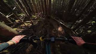
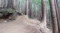
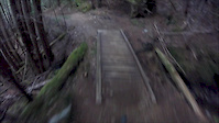
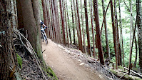
Singletrack downhill trail bench cut down the mountain. This is the most popular trail on Copper and is the easiest run on the mountain. It winds down and crosses several small drainages. There are small natural rock jumps and a few natural side-hits throughout the trail. No mandatory ttfs, only wood bridges that are all solid. You can see remnants of an old log bridge off in the forest near the bottom. Watch out for hikers as this trail is often used to access the Thornhill Mtn trail.

Local Trail Association
Traditionally Indigenous Territory

Recent Activity on Trail

Past Week
  • 2 rides
  • 3 miles average
6 Months
  • 6 rides
  • 4 miles avg distance
All
  • 147 rides
  • Last: Jun 29, 2026
c1c2c3c4
January
February
March
April
May
June
July
August
September
October
November
December
update trails status or condition

Packhorse Trail Reports

statusdatedescription
Jun 27, 2026 @ 6:38pm (America/Vancouver)
Jun 27, 2026
Bridges across the slide are amazing. The work is much appreciated.
May 18, 2026 @ 8:35pm (America/Vancouver)
May 18, 2026
Bridges have been rebuilt and trail is rideable Huge thanks to whoever has been doing all the work!
Oct 20, 2025 @ 1:18pm (America/Vancouver)
Oct 20, 2025
reporter
Apr 21, 2025 @ 3:33pm
Apr 21, 2025
reporter Update for 2025 - as is well known from the reports last year, the trail has 4 major debris flows across the trail rendering it impassable and...
Sep 25, 2024 @ 11:55am
Sep 25, 2024
reporter Multiple slides have taken out bridges, leaving all drainage crossings unpassable. All vehicle access to the top of Packhorse is currently blocked...
more »
Status:
on Jun 27, 2026
Ideal
Avg: 4.11 (11 votes)
Your vote: 0

view (1,607)
close
3D
Trail Conditions
  • Unknown
  • Snow Groomed
  • Snow Packed
  • Snow Covered
  • Snow Cover Partial
  • Freeze/thaw Cycle
  • Icy
  • Prevalent Mud
  • Wet
  • Variable
  • Ideal
  • Dry
  • Very Dry
Trail Flow (Ridden Direction)
Trailforks scans users ridelogs to determine the most popular direction each trail is ridden. A good flowing trail network will have most trails flowing in a single direction according to their intension.
The colour categories are based on what percentage of riders are riding a trail in its intended direction.
  • > 96%
  • > 90%
  • > 80%
  • > 70%
  • > 50%
  • < 50%
  • bi-directional trail
  • no data
Trail Last Ridden
Trailforks scans ridelogs to determine the last time a trail was ridden.
  • < 2 days
  • < 1 week
  • < 2 weeks
  • < 1 month
  • < 6 months
  • > 6 months
Trail Ridden Direction
The intended direction a trail should be ridden.
  • Downhill Only
  • Downhill Primary
  • Both Directions
  • Uphill Primary
  • Uphill Only
  • One Direction
Contribute Details
Colors indicate trail is missing specified detail.
  • Description
  • Photos
  • Description & Photos
  • Videos
Trail Popularity ?
Trailforks scans ridelogs to determine which trails are ridden the most in the last 9 months. Trails are compared with nearby trails in the same city region with a possible 25 colour shades. Think of this as a heatmap, more rides = more kinetic energy = warmer colors.
  • most popular
  • popular
  • less popular
  • not popular
ATV/ORV/OHV Filter
Max Vehicle Width
inches
US Cell Coverage
Legend
cell carrier legend

Radar Time
Activity Recordings
Trailforks uses anonymized public activity data. ?
Activity Recordings
Trailforks uses anonymized public activity data. ?
Personal Heatmap
Activity Types
all / none
Options
2
Date range month
Winter Trails
Warning A routing network for winter maps does not exist. Selecting trails using the winter trails layer has been disabled.
Missing Trails
Most Popular
Least Popular
Trails are colored based on popularity. The more popular a trail is, the more red. Less popular trails trend towards green.
Jump Magnitude Heatmap
Heatmap of where riders jump on trails. Zoom in to see individual jumps, click circles to view jump details.
BC Backroad Status

Service Road Atlas is a free to use, community-driven service for viewing and creating reports on the numerous back-country service roads around B.C. and Alberta.

map legend
Slope Aspect
Direction the slope faces
Flat N NE E SE S SW W NW
Trails Deemphasized
Trails are shown in grey.
disable
Only show trails with no bike usage.
Enable
Suggested Layers
Based on selected activity type

    Save the current map location and zoom level as your default home location whenever this page is loaded.

    Save
        Directions to packhorse trailhead (54.486510, -128.461840)

        Photos

        34 more »
        233 |
        Aug 4, 2020 @ 4:35pm
        Aug 4, 2020
        141 |
        May 26, 2020 @ 3:00pm
        May 26, 2020
        311 |
        Jun 7, 2014 @ 11:50am
        Jun 7, 2014
        344 |
        Jun 7, 2014 @ 11:51am
        Jun 7, 2014

        Videos

        16 more »
        Copper Mountain | Terrace, BC
        13:24 | 180 | Jan 30, 2025 , Terrace
        Packhorse Launcher
        0:07 | 364 | Jun 26, 2018 , Terrace
        packhore trail 7/29/17
        3:46 | 270 | Aug 10, 2017 , Terrace
        Wild Decent 2015  Clip 1
        0:07 | 314 | Aug 23, 2015 , Terrace

        Trail Lists

        Routes with this trail

        8 miles 2,702 ft 49
        If you are in the area for a good time but not a long time, this route will show you the best copper...
        5 miles 1,652 ft 39
        Ride lower trails and maximize your air time and freeride thirst. Add in for and longer experience.
        7 miles 2,829 ft 44
        The diamond, four expert trails that are arguably the best steep trails on copper mountain.

        Reviews / Comments

        No reviews yet, be the first to write a review or ask a question.
        Use trail reports to comment on trail conditions.


        We hope you've been enjoying Trailforks!

        Create a FREE account to view trail comments and much more.

        • By plucas-catalystTF Pro SAPBS & contributors
        • #5955 - 5,027 views

        Frequently Asked Questions About Packhorse

        Where is Packhorse located?
        Packhorse is located in Copper Mountain, Terrace, British Columbia, Canada. It is part of the Copper Mountain trail network. The trailhead is located at coordinates 54.48651, -128.46184.
        How hard is Packhorse?
        Packhorse is rated as Blue difficulty. The average grade is 14.5%.
        What is the elevation gain for Packhorse?
        The trail has 188 m of elevation descent. The elevation ranges from 222 m to 410 m.
        Is Packhorse a point to point trail?
        Packhorse is not a point to point trail. The direction is Downhill Primary. The trail type is singletrack.

        Hit the Trail

        Open in App

        Get this trail on your phone instantly.
        open trail in app

        Download Trail

        Save to wishlist, Garmin & download.
        save the trail

        Find Related Routes

        Find routes and users activities that include this trail.
        find routes for this trail

        You must enter a description before submitting.