more stats
2,247 ft
Distance
18 ft
Climb
-204 ft
Descent
00:10:27
Avg time
-185 ft
Altitude change
2,661 ft
Altitude min
2,863 ft
Altitude max
2,847 ft
Altitude start
2,661 ft
Altitude end
-8.2%
Grade
-26%
Grade max
15.8%
Grade min
272 ft
Distance climb
1,900 ft
Distance down
75 ft
Distance flat
00:10:27
Avg time

Padawan - Lower Details

  • Activities
    • Mountain Bike
    • E-Bike
  • Riding Area
    Mount Harry Davis
    Houston, British Columbia
  • Difficulty Rating
  • Local Popularity
    80 in Mountain Biking
  • Global Ranking
    #80620 in Mountain Biking
  • Trail Exposure
    Normal
  • Trail Type
    Machine Groomed
  • Bike Type
    AM, Fat
  • Direction
    Downhill Only[+]
    • Downhill Only for E-Biking
  • Physical Rating
    Moderate
  • Trail Visibility
    Always easy to follow
  • Season
    All year
  • Family Friendly
    Yes
  • Dogs Allowed
    Yes
  • eBike Allowed
    Yes up to Class 1
  • TTFs on Trail
    Berm, Jump
  • Year Opened
    2018
  • Land Owner
    Houston Mountain Bike Association

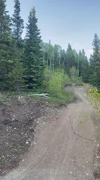
Machine build with friendly berms and table tops.Padawan is an excellent

Access Info

Up Harry Davis way, past the bottom lot where the trails end, about 1km up the road take a right to the Family center and the trail head is at the family center. Lots of signs to help guide you up

Local Trail Association
Traditionally Indigenous Territory

Recent Activity on Trail

Past Week
  • 0 rides
  •  
6 Months
  • 3 rides
  • 5 miles avg distance
All
  • 33 rides
  • Last: Jun 2, 2026
c1c2c3c4
January
February
March
April
May
June
July
August
September
October
November
December
update trails status or condition

Padawan - Lower Trail Reports

statusdatedescription
May 17, 2026 @ 3:57pm (America/Vancouver)
May 17, 2026
reporter
Apr 3, 2026 @ 9:39am (America/Vancouver)
Apr 3, 2026
Aug 19, 2025 @ 7:11am
Aug 19, 2025
There is one tree creating partial blockage about 1/4 the way up from the bottom. Creates more of an issue when coming down at speed.
May 22, 2025 @ 5:17pm
May 22, 2025
Good climbing trail with a few drier sections. There's a chance of collisions as it's a two way trail with ok but not great sightlines in a few places
Nov 20, 2022 @ 1:47pm
Nov 20, 2022
the top loop is best, although there is a track all the way down from P2 with road as uptrack
more »
Status:
on May 17, 2026
Variable
Avg: 3.99 (2 votes)
Your vote: 0

view (173)
close
3D
Trail Conditions
  • Unknown
  • Snow Groomed
  • Snow Packed
  • Snow Covered
  • Snow Cover Partial
  • Freeze/thaw Cycle
  • Icy
  • Prevalent Mud
  • Wet
  • Variable
  • Ideal
  • Dry
  • Very Dry
Trail Flow (Ridden Direction)
Trailforks scans users ridelogs to determine the most popular direction each trail is ridden. A good flowing trail network will have most trails flowing in a single direction according to their intension.
The colour categories are based on what percentage of riders are riding a trail in its intended direction.
  • > 96%
  • > 90%
  • > 80%
  • > 70%
  • > 50%
  • < 50%
  • bi-directional trail
  • no data
Trail Last Ridden
Trailforks scans ridelogs to determine the last time a trail was ridden.
  • < 2 days
  • < 1 week
  • < 2 weeks
  • < 1 month
  • < 6 months
  • > 6 months
Trail Ridden Direction
The intended direction a trail should be ridden.
  • Downhill Only
  • Downhill Primary
  • Both Directions
  • Uphill Primary
  • Uphill Only
  • One Direction
Contribute Details
Colors indicate trail is missing specified detail.
  • Description
  • Photos
  • Description & Photos
  • Videos
Trail Popularity ?
Trailforks scans ridelogs to determine which trails are ridden the most in the last 9 months. Trails are compared with nearby trails in the same city region with a possible 25 colour shades. Think of this as a heatmap, more rides = more kinetic energy = warmer colors.
  • most popular
  • popular
  • less popular
  • not popular
ATV/ORV/OHV Filter
Max Vehicle Width
inches
US Cell Coverage
Legend
cell carrier legend

Radar Time
Activity Recordings
Trailforks uses anonymized public activity data. ?
Activity Recordings
Trailforks uses anonymized public activity data. ?
Personal Heatmap
Activity Types
all / none
Options
2
Date range month
Winter Trails
Warning A routing network for winter maps does not exist. Selecting trails using the winter trails layer has been disabled.
Missing Trails
Most Popular
Least Popular
Trails are colored based on popularity. The more popular a trail is, the more red. Less popular trails trend towards green.
Jump Magnitude Heatmap
Heatmap of where riders jump on trails. Zoom in to see individual jumps, click circles to view jump details.
BC Backroad Status

Service Road Atlas is a free to use, community-driven service for viewing and creating reports on the numerous back-country service roads around B.C. and Alberta.

map legend
Slope Aspect
Direction the slope faces
Flat N NE E SE S SW W NW
Trails Deemphasized
Trails are shown in grey.
disable
Only show trails with no bike usage.
Enable
Suggested Layers
Based on selected activity type

    Save the current map location and zoom level as your default home location whenever this page is loaded.

    Save
        Directions to padawan-lower trailhead (54.421560, -126.655130)

        Photos

        11 more »
        12 |
        May 19, 2026 @ 10:42pm
        May 19, 2026
        24 |
        May 19, 2026 @ 2:38pm
        May 19, 2026
        10 |
        May 19, 2026 @ 2:38pm
        May 19, 2026
        14 |
        May 19, 2026 @ 2:37pm
        May 19, 2026

        Videos

        2 more »
        0:10 | 3 | May 20, 2026 , Houston
        0:06 | 3 | May 20, 2026 , Houston

        2 Reviews & Comments


        We hope you've been enjoying Trailforks!

        Create a FREE account to view trail comments and much more.

        • By lo33 & contributors
        • #150375 - 1,027 views

        Frequently Asked Questions About Padawan

        Where is Padawan located?
        Padawan is located in Mount Harry Davis, Houston, British Columbia, Canada. It is part of the Mount Harry Davis trail network. The trailhead is located at coordinates 54.42161, -126.65498.
        How hard is Padawan?
        Padawan is rated as Green difficulty. The physical rating is Easy. The average grade is 5.7%. The climb difficulty is rated Green.
        What is the elevation gain for Padawan?
        Padawan has 48 ft of elevation gain. The trail has 241 ft of elevation descent. The elevation ranges from 2,649 ft to 2,885 ft.
        Is Padawan a point to point trail?
        Padawan is not a point to point trail. The direction is Both Directions. The trail type is machine groomed.

        Hit the Trail

        Open in App

        Get this trail on your phone instantly.
        open trail in app

        Download Trail

        Save to wishlist, Garmin & download.
        save the trail

        Find Related Routes

        Find routes and users activities that include this trail.
        find routes for this trail

        You must enter a description before submitting.