more stats
2,275 ft
Distance
28 ft
Climb
-68 ft
Descent
00:03:38
Avg time
-40 ft
Altitude change
134 ft
Altitude min
184 ft
Altitude max
178 ft
Altitude start
138 ft
Altitude end
-1.745%
Grade
-10.784%
Grade max
16.227%
Grade min
651 ft
Distance climb
1,244 ft
Distance down
380 ft
Distance flat
00:03:38
Avg time

Pool Shark Details

  • Activities
    • Mountain Bike
    • E-Bike
    • Hike
    • Trail Running
  • Riding Area
    Redlands Track Park
    Redland City
  • Difficulty Rating
  • Voted Difficulty
    Blue (4 votes)
  • Local Popularity
    80 in Mountain Biking [+]
    • 70 in E-Biking
    • 40 in Trail Running
    • 50 in Hiking
  • Global Ranking
    #26893 in Mountain Biking [+]
    • #48535 in E-Biking
    • #131220 in Trail Running
    • #106960 in Hiking
  • Trail Type
    Singletrack
  • Bike Type
    XC
  • Direction
    One Direction
    Popular Direction Shown
  • Physical Rating
    Moderate
  • Dogs Allowed
    Yes
  • eBike Allowed
    Yes up to Class 1
  • TTFs on Trail
    Berm, Log Ride, Other

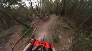
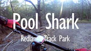
The Pool Shark is a cross between a nature trail and a pump track. It is a fun and 'twisty' trail built on dirt mounds leftover from historical soil dumping activities. The trail is set among thick Casuarina regrowth and offers various log features, sharp rises and descents, doubles and blind corners. The trail is downhill and is one way.

Traditionally Indigenous Territory

Recent Activity on Trail

Past Week
  • 1 rides
  • 11 miles average
6 Months
  • 60 rides
  • 12 miles avg distance
All
  • 1,312 rides
  • Last: Jun 28, 2026
c1c2c3c4
January
February
March
April
May
June
July
August
September
October
November
December
Status:
on Sep 28, 2025
Ideal
Avg: 4.24 (6 votes)
Your vote: 0

view (6,981)
close
3D
Trail Conditions
  • Unknown
  • Snow Groomed
  • Snow Packed
  • Snow Covered
  • Snow Cover Partial
  • Freeze/thaw Cycle
  • Icy
  • Prevalent Mud
  • Wet
  • Variable
  • Ideal
  • Dry
  • Very Dry
Trail Flow (Ridden Direction)
Trailforks scans users ridelogs to determine the most popular direction each trail is ridden. A good flowing trail network will have most trails flowing in a single direction according to their intension.
The colour categories are based on what percentage of riders are riding a trail in its intended direction.
  • > 96%
  • > 90%
  • > 80%
  • > 70%
  • > 50%
  • < 50%
  • bi-directional trail
  • no data
Trail Last Ridden
Trailforks scans ridelogs to determine the last time a trail was ridden.
  • < 2 days
  • < 1 week
  • < 2 weeks
  • < 1 month
  • < 6 months
  • > 6 months
Trail Ridden Direction
The intended direction a trail should be ridden.
  • Downhill Only
  • Downhill Primary
  • Both Directions
  • Uphill Primary
  • Uphill Only
  • One Direction
Contribute Details
Colors indicate trail is missing specified detail.
  • Description
  • Photos
  • Description & Photos
  • Videos
Trail Popularity ?
Trailforks scans ridelogs to determine which trails are ridden the most in the last 9 months. Trails are compared with nearby trails in the same city region with a possible 25 colour shades. Think of this as a heatmap, more rides = more kinetic energy = warmer colors.
  • most popular
  • popular
  • less popular
  • not popular
ATV/ORV/OHV Filter
Max Vehicle Width
inches
US Cell Coverage
Legend
cell carrier legend

Radar Time
Activity Recordings
Trailforks uses anonymized public activity data. ?
Activity Recordings
Trailforks uses anonymized public activity data. ?
Personal Heatmap
Activity Types
all / none
Options
2
Date range month
Winter Trails
Warning A routing network for winter maps does not exist. Selecting trails using the winter trails layer has been disabled.
Missing Trails
Most Popular
Least Popular
Trails are colored based on popularity. The more popular a trail is, the more red. Less popular trails trend towards green.
Jump Magnitude Heatmap
Heatmap of where riders jump on trails. Zoom in to see individual jumps, click circles to view jump details.
BC Backroad Status

Service Road Atlas is a free to use, community-driven service for viewing and creating reports on the numerous back-country service roads around B.C. and Alberta.

map legend
Slope Aspect
Direction the slope faces
Flat N NE E SE S SW W NW
Trails Deemphasized
Trails are shown in grey.
disable
Only show trails with no bike usage.
Enable
Suggested Layers
Based on selected activity type

    Save the current map location and zoom level as your default home location whenever this page is loaded.

    Save
        Directions to pool-shark trailhead (-27.552250, 153.243350)

        Photos

        3 more »
        66 |
        Dec 14, 2020 @ 11:10pm
        Dec 14, 2020
        145 |
        Sep 19, 2020 @ 4:25pm
        Sep 19, 2020
        242 |
        Sep 27, 2015 @ 4:51am
        Sep 27, 2015

        Videos

        2 more »
        Scribbly Gums Conservation Area MTB trails -...
        3:24 | 298 | Aug 6, 2024 , Redland City
        Pool Shark //Redlands Track Park
        2:51 | 1427 | Jan 5, 2020 , Redland City

        Routes with this trail

        4.0 9 miles 893 ft 18 Loop
        nice not too hard route a Redlands track park
        12 miles 775 ft 25 Loop
        20km loop starting at the Kinross entrance.
        14 miles 899 ft 25 Loop
        Loop includes most of the Redlands Track Park trails and is ridden in a direction that gives the best...

        3 Reviews & Comments


        We hope you've been enjoying Trailforks!

        Create a FREE account to view trail comments and much more.

        • By Sparkybreno & contributors
        • #92641 - 2,740 views

        Frequently Asked Questions About Pool Shark

        Where is Pool Shark located?
        Pool Shark is located in Redlands Track Park, Redland City, Australia. It is part of the Redlands Track Park trail network. The trailhead is located at coordinates -27.55225, 153.24335.
        How hard is Pool Shark?
        Pool Shark is rated as Blue difficulty. The physical rating is Moderate. The average grade is 1.745%.
        What is the elevation gain for Pool Shark?
        Pool Shark has 9 m of elevation gain. The trail has 21 m of elevation descent. The elevation ranges from 41 m to 56 m.
        Is Pool Shark a point to point trail?
        Yes, Pool Shark is a point to point trail. The direction is One Direction. The trail type is singletrack.

        Hit the Trail

        Open in App

        Get this trail on your phone instantly.
        open trail in app

        Download Trail

        Save to wishlist, Garmin & download.
        save the trail

        Find Related Routes

        Find routes and users activities that include this trail.
        find routes for this trail

        You must enter a description before submitting.