4,203 ft
Distance
-287 ft
Descent
00:07:43
Avg time

Potluck Details

  • Activities
    • Mountain Bike
    • E-Bike
    • Hike
    • Trail Running
  • Riding Area
    Cumberland trail network
    Cumberland, British Columbia
  • Difficulty Rating
  • Voted Difficulty
    Black Diamond (2 votes)
  • Trail Type
    Singletrack
  • Bike Type
    AM, XC
  • Physical Rating
    Moderate
  • Dogs Allowed
    Yes
  • eBike Allowed
  • TTFs on Trail
    Bridge, Skinny
  • Global Ranking
    #6751 in Mountain Biking [+]
    • #21568 in Trail Running
    • #42298 in Hiking
  • Local Popularity
    50 in Mountain Biking [+]
    • 55 in E-Biking
    • 60 in Trail Running
    • 35 in Hiking

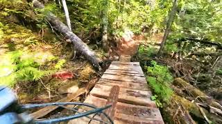
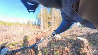
Lots of variety in this trail, single track downhill and a short climb into a short road section, then two long sections of woodwork to set you up going into Thirsty Beaver.

Local Trail Association
Traditionally Indigenous Territory
More Stats for Potluck mountain bike trail trail
  • Altitude change
    -289 ft
  • Altitude min
    1,524 ft
  • Altitude max
    1,813 ft
  • Altitude start
    1,813 ft
  • Altitude end
    1,526 ft
  • Grade
    -6.9%
  • Grade max
    -19.6%
  • Grade min
    2%
  • Distance climb
    33 ft
  • Distance down
    3,717 ft
  • Distance flat
    453 ft
  • Avg time
    00:07:43
  • Avg reverse time
    00:17:59
  • view trail stats
Status:
on Apr 20, 2025
Ideal
Avg: 3.85 (35 votes)
Your vote: 0

view (2,613)
close
3D
Trail Conditions
  • Unknown
  • Snow Groomed
  • Snow Packed
  • Snow Covered
  • Snow Cover Partial
  • Freeze/thaw Cycle
  • Icy
  • Prevalent Mud
  • Wet
  • Variable
  • Ideal
  • Dry
  • Very Dry
Trail Flow (Ridden Direction)
Trailforks scans users ridelogs to determine the most popular direction each trail is ridden. A good flowing trail network will have most trails flowing in a single direction according to their intension.
The colour categories are based on what percentage of riders are riding a trail in its intended direction.
  • > 96%
  • > 90%
  • > 80%
  • > 70%
  • > 50%
  • < 50%
  • bi-directional trail
  • no data
Trail Last Ridden
Trailforks scans ridelogs to determine the last time a trail was ridden.
  • < 2 days
  • < 1 week
  • < 2 weeks
  • < 1 month
  • < 6 months
  • > 6 months
Trail Ridden Direction
The intended direction a trail should be ridden.
  • Downhill Only
  • Downhill Primary
  • Both Directions
  • Uphill Primary
  • Uphill Only
  • One Direction
Contribute Details
Colors indicate trail is missing specified detail.
  • Description
  • Photos
  • Description & Photos
  • Videos
Trail Popularity ?
Trailforks scans ridelogs to determine which trails are ridden the most in the last 9 months. Trails are compared with nearby trails in the same city region with a possible 25 colour shades. Think of this as a heatmap, more rides = more kinetic energy = warmer colors.
  • most popular
  • popular
  • less popular
  • not popular
ATV/ORV/OHV Filter
Max Vehicle Width
inches
US Cell Coverage
Legend
cell carrier legend

Radar Time
x Activity Recordings
Trailforks users anonymized public ridelogs from the past 6 months.
  • mountain biking recent
  • mountain biking (>6 month)
  • hiking (1 year)
  • moto (1 year)
Activity Recordings
Trailforks users anonymized public skilogs from the past 12 months.
  • Downhill Ski
  • Backcountry Ski
  • Nordic Ski
  • Snowmobile
Winter Trails
Warning A routing network for winter maps does not exist. Selecting trails using the winter trails layer has been disabled.
x Missing Trails
Most Popular
Least Popular
Trails are colored based on popularity. The more popular a trail is, the more red. Less popular trails trend towards green.
Jump Magnitude Heatmap
Heatmap of where riders jump on trails. Zoom in to see individual jumps, click circles to view jump details.
Trails Deemphasized
Trails are shown in grey.
disable
Only show trails with NO bikes.
enable

Save the current map location and zoom level as your default home location whenever this page is loaded.

Save
      Directions to potluck trailhead (49.586720, -125.069050)
      update trails status or condition

      Potluck Trail Reports

      statusdatedescription
      Apr 20, 2025 @ 2:06pm
      Apr 20, 2025
      Mar 29, 2025 @ 10:58am
      Mar 29, 2025
      Feb 23, 2025 @ 8:48am
      Feb 23, 2025
      Tree down across trail
      Nov 25, 2024 @ 6:31pm
      Nov 25, 2024
      Nov 25, 2024 @ 6:31pm
      Nov 25, 2024
      trees down most on lower pot on the last bridge big trees need chain saw one at the top of the road between lower pot and upper pot
      view all reports »

      Recent Ridelog Activity on Trail

      Past Week
      • 2 rides
      • 24.9 km avg distance
      6 Months
      • 42 rides
      • 28.0 km avg distance
      All
      • 452 rides
      • Last: Jul 18, 2025

      Photos

      more »
      5 |
      Dec 29, 2024 @ 2:37pm
      Dec 29, 2024
      28 |
      Aug 16, 2023 @ 1:46pm
      Aug 16, 2023
      24 |
      Aug 16, 2023 @ 1:46pm
      Aug 16, 2023
      29 |
      Aug 16, 2023 @ 1:46pm
      Aug 16, 2023

      Routes with this trail

      more »
      titledistance
      Gravity Nines 202321 miles
      Cumberland up to the top14 miles
      Labour Day 3019 miles
      2023 Devils Ladder 30k20 miles

      5 Reviews & Comments


      We hope you've been enjoying Trailforks!

      Create a FREE account to view trail comments and much more.

      Videos

      more »
      Upper Potluck
      2:41 | 30 | Apr 6, 2025 , Cumberland
      Potluck
      2:15 | 31 | Feb 5, 2025 , Cumberland
      youtuber I have never seen so many ladder bridges in...
      15:00 | 131 | Dec 12, 2023 , Cumberland
      youtuber Best Mountain Biking in Cumberland, BC -...
      10:45 | 389 | Feb 25, 2022 , Cumberland
      • By canadakaTF Pro Trailforks & contributors
      • #2034 - 4,222 views

      You must enter a description before submitting.