more stats
4,042 ft
Distance
-543 ft
Descent
00:10:18
Avg time
-543 ft
Altitude change
583 ft
Altitude min
1,126 ft
Altitude max
1,126 ft
Altitude start
584 ft
Altitude end
-13.4%
Grade
-39.5%
Grade max
0.6%
Grade min
3,927 ft
Distance down
102 ft
Distance flat
00:10:18
Avg time

Quebec Cup Details

  • Activities
    • Mountain Bike
  • Riding Area
    Camp Fortune
    Chelsea, Quebec
  • Difficulty Rating
  • Voted Difficulty
    Black Diamond (1 vote)
  • Local Popularity
    100 in Mountain Biking
  • Global Ranking
    #5143 in Mountain Biking
  • Trail Type
    Singletrack
  • Bike Type
    DH, AM
  • Climb Difficulty
    Blue
  • Physical Rating
    Hard
  • Trail Visibility
    Sometimes hard to follow
  • eBike Allowed
  • TTFs on Trail
    Berm, Bridge, Drop, Jump, Gap Jump, Ladder Bridge, Rock Face, Rock Garden, Other
  • Land Owner
    Camp Fortune

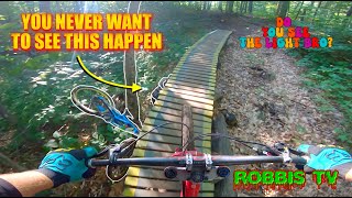
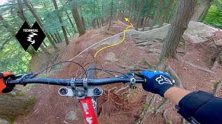
The crown jewel of Camp fortune riding this primary downhill not only gives direct access to 6 or more trails it also is fun on it`s own. It contains many man made TTF`s including natural rock, bridge and roll features.
A must try

Access Info

At the top of skyline start down main pitch and look for wooden trail sigh with maple leaf
Or
Go to valley and follow trail not marked with national

Bike Park

Local Trail Association

Recent Activity on Trail

Past Week
  • 14 rides
  • 11.0 km average
6 Months
  • 49 rides
  • 12.9 km avg distance
All
  • 681 rides
  • Last: Jun 28, 2026
c1c2c3c4
January
February
March
April
May
June
July
August
September
October
November
December
update trails status or condition

Quebec Cup Trail Reports

Status:
on Jun 16, 2026
Ideal
Avg: 4.52 (15 votes)
Your vote: 0

view (8,588)
close
3D
Trail Conditions
  • Unknown
  • Snow Groomed
  • Snow Packed
  • Snow Covered
  • Snow Cover Partial
  • Freeze/thaw Cycle
  • Icy
  • Prevalent Mud
  • Wet
  • Variable
  • Ideal
  • Dry
  • Very Dry
Trail Flow (Ridden Direction)
Trailforks scans users ridelogs to determine the most popular direction each trail is ridden. A good flowing trail network will have most trails flowing in a single direction according to their intension.
The colour categories are based on what percentage of riders are riding a trail in its intended direction.
  • > 96%
  • > 90%
  • > 80%
  • > 70%
  • > 50%
  • < 50%
  • bi-directional trail
  • no data
Trail Last Ridden
Trailforks scans ridelogs to determine the last time a trail was ridden.
  • < 2 days
  • < 1 week
  • < 2 weeks
  • < 1 month
  • < 6 months
  • > 6 months
Trail Ridden Direction
The intended direction a trail should be ridden.
  • Downhill Only
  • Downhill Primary
  • Both Directions
  • Uphill Primary
  • Uphill Only
  • One Direction
Contribute Details
Colors indicate trail is missing specified detail.
  • Description
  • Photos
  • Description & Photos
  • Videos
Trail Popularity ?
Trailforks scans ridelogs to determine which trails are ridden the most in the last 9 months. Trails are compared with nearby trails in the same city region with a possible 25 colour shades. Think of this as a heatmap, more rides = more kinetic energy = warmer colors.
  • most popular
  • popular
  • less popular
  • not popular
ATV/ORV/OHV Filter
Max Vehicle Width
inches
US Cell Coverage
Legend
cell carrier legend

Radar Time
Activity Recordings
Trailforks uses anonymized public activity data. ?
Activity Recordings
Trailforks uses anonymized public activity data. ?
Personal Heatmap
Activity Types
all / none
Options
2
Date range month
Winter Trails
Warning A routing network for winter maps does not exist. Selecting trails using the winter trails layer has been disabled.
Missing Trails
Most Popular
Least Popular
Trails are colored based on popularity. The more popular a trail is, the more red. Less popular trails trend towards green.
Jump Magnitude Heatmap
Heatmap of where riders jump on trails. Zoom in to see individual jumps, click circles to view jump details.
BC Backroad Status

Service Road Atlas is a free to use, community-driven service for viewing and creating reports on the numerous back-country service roads around B.C. and Alberta.

map legend
Slope Aspect
Direction the slope faces
Flat N NE E SE S SW W NW
Trails Deemphasized
Trails are shown in grey.
disable
Only show trails with no bike usage.
Enable
Suggested Layers
Based on selected activity type

    Save the current map location and zoom level as your default home location whenever this page is loaded.

    Save
        Directions to quebec-cup trailhead (45.507150, -75.839700)

        Photos

        88 more »
        186 |
        Sep 14, 2022 @ 4:29am
        Sep 14, 2022
        146 |
        Sep 14, 2022 @ 4:29am
        Sep 14, 2022
        114 |
        Jun 17, 2022 @ 6:09pm
        Jun 17, 2022
        67 |
        Jun 17, 2022 @ 6:09pm
        Jun 17, 2022

        Videos

        26 more »
        youtuber Most INSANE Moments of 2023! (Pt. 6) -...
        9:36 | 147 | Jan 31, 2024 , Chelsea
        youtuber Most INSANE Moments of 2023! (Pt. 5) - 'Camp...
        10:02 | 121 | Jan 23, 2024 , Chelsea
        FORTUNE OPENING DAY//2023//CHEALSEA QC.//The...
        28:47 | 157 | Jun 18, 2023 , Chelsea
        youtuber Most INSANE Moments of 2022! (Pt. 6) -...
        16:45 | 170 | Apr 15, 2023 , Chelsea

        Routes with this trail

        3,937 ft 2
        2023 OMBA Social Enduro - Stage C This stage will be used by Pro and Expert categories
        3,579 ft 6 ft 3
        Stage B of the 2024 OMBA Social Enduro
        4,291 ft 4
        Stage A for the 2024 OMBA Social Enduro

        Reviews / Comments

        No reviews yet, be the first to write a review or ask a question.
        Use trail reports to comment on trail conditions.


        We hope you've been enjoying Trailforks!

        Create a FREE account to view trail comments and much more.

        • By StephaneMarceauTF Pro TRAILFORKS & contributors
        • #32829 - 4,377 views

        Frequently Asked Questions About Quebec Cup

        Where is Quebec Cup located?
        Quebec Cup is located in Camp Fortune, Chelsea, Quebec, Canada. It is part of the Camp Fortune trail network. The trailhead is located at coordinates 45.50715, -75.8397.
        How hard is Quebec Cup?
        Quebec Cup is rated as Black Diamond difficulty. The physical rating is Hard. The average grade is 13.4%. The climb difficulty is rated Blue.
        What is the elevation gain for Quebec Cup?
        The trail has 543 ft of elevation descent. The elevation ranges from 583 ft to 1,126 ft.
        How long is Quebec Cup?
        Quebec Cup is 4,042 ft long. The trail type is singletrack.

        Hit the Trail

        Open in App

        Get this trail on your phone instantly.
        open trail in app

        Download Trail

        Save to wishlist, Garmin & download.
        save the trail

        Find Related Routes

        Find routes and users activities that include this trail.
        find routes for this trail

        You must enter a description before submitting.