
more stats
1.6 miles
Distance
38 ft
Climb
-354 ft
Descent
00:08:43
Avg time
-315 ft
Altitude change
5,351 ft
Altitude min
5,667 ft
Altitude max
5,667 ft
Altitude start
5,351 ft
Altitude end
-3.8%
Grade
-27.6%
Grade max
9.1%
Grade min
1,293 ft
Distance climb
1 mile
Distance down
1,352 ft
Distance flat
00:08:43
Avg time

RADium Details

  • Activities
    • Mountain Bike
    • E-Bike
    • Adaptive Bike
    • Hike
    • Trail Running
  • Riding Area
    Mud Springs
    Moab, Utah
  • Difficulty Rating
  • Local Popularity
    80 in Mountain Biking [+]
    • 90 in E-Biking
    • 70 in Trail Running
    • 55 in Hiking
    • 5 in Adaptive Biking
  • Global Ranking
    #11543 in Mountain Biking [+]
    • #21150 in E-Biking
    • #134633 in Trail Running
    • #146257 in Hiking
    • #14539 in Adaptive Biking
  • State Ranking
    #244 in Mountain Biking · Utah [+]
    • #284 in E-Biking
    • #2,975 in Trail Running
    • #3,444 in Hiking
    • #288 in Adaptive Biking
  • Hiking SAC Scale
    T1 Hiking
  • Trail Exposure
    Normal
  • Trail Type
    Singletrack
  • Bike Type
  • Direction
    Downhill Only[+]
    Popular Direction Shown
    • Downhill Only for E-Biking
    • Downhill Only for Trail Running
    • Downhill Only for Hiking
    • Downhill Only for Adaptive Biking
  • Climb Difficulty
    Green
  • Physical Rating
    Easy
  • Trail Visibility
    Always easy to follow
  • Family Friendly
    Yes
  • Dogs Allowed
    Yes
  • eBike Allowed
    Yes up to Class 1
  • TTFs on Trail
    Berm
  • Lighting
    No
  • Land Owner

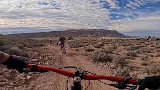
RADium is the shorter loop option, winding through the central section of the Mud Springs Cauldron. The trail kicks off with a fast, flowy downhill, then traverses out of the cauldron before dropping down the west slope back toward the trailhead. Riders will enjoy its quick pace, smooth turns, and playful descent that perfectly complements the climb up Up235.

Mud Springs was built with adaptive friendly standards and is great for handcycle riders. This trail ranges between 40-48" wide and has no pinch points narrower than 43 inches. Some berms are present however they have flatter bottoms, and the out slope of tread does not exceed 10 degrees. Turns have a radius of 15 feet or greater.

MUD WARNING The system is high in clay soils and does not hold up well when wet. Please do not ride during or after rain or snow events. Doing so will leave ruts and damage the trails.

Access Info

Use caution turning off of HWY 191 onto Yellow Circle Road as the turning place is in a passing lane.

Disclaimer

WILDLIFE CLOSURE from December 1st to April 15th

Tags
BermsFamily friendlyFlowy

Traditionally Indigenous Territory

Recent Activity on Trail

Past Week
  • 5 rides
  • 10 miles average
6 Months
  • 53 rides
  • 10 miles avg distance
All
  • 70 rides
  • Last: Oct 30, 2026
c1c2c3c4
January
February
March
April
May
June
July
August
September
October
November
December
Status:
on Oct 18, 2026
Ideal
Avg: 4.24 (2 votes)
Your vote: 0

view (263)
close
      Directions to radium trailhead (38.435540, -109.410070)

      Photos

      5 more »
      mtb
      129 |
      Nov 20, 2025 @ 1:05pm
      Nov 20, 2025
      mtb
      110 |
      Nov 20, 2025 @ 1:05pm
      Nov 20, 2025
      mtb
      101 |
      Nov 20, 2025 @ 1:05pm
      Nov 20, 2025
      mtb
      103 |
      Nov 20, 2025 @ 1:05pm
      Nov 20, 2025

      Videos

      1 more »
      Moab’s New Mud Springs Trails (RADium to...
      mtb
      7:08 | 73 | Aug 31, 2026 , Moab
      5.0 ★★★★★
      2 Ratings
      5 ★ 100%
      4 ★
      3 ★
      2 ★
      1 ★

      1 Review & Comments


      We hope you've been enjoying Trailforks!

      Create a FREE account to view all trail reviews and much more.

      • By GrandCountyTrailsTF Pro MTM & contributors
      • #883634 - 582 views

      Frequently Asked Questions

      ▼ Where is RADium located?
      RADium is located in Mud Springs, Moab, Utah, United States. It is part of the Mud Springs trail network. The trailhead is located at coordinates 38.43554, -109.41007.
      ▼ How hard is RADium?
      RADium is rated as Green difficulty. The physical rating is Easy. The average grade is 3.8%. The climb difficulty is rated Green.
      ▼ What is the elevation gain for RADium?
      RADium has 38 ft of elevation gain. The trail has 354 ft of elevation descent. The elevation ranges from 5,351 ft to 5,667 ft.
      ▼ Is RADium a point to point trail?
      Yes, RADium is a point to point trail. The direction is Downhill Only. The trail type is singletrack.
      ▼ How long is RADium?
      RADium is 1.6 miles long. The trail type is singletrack.
      ▼ Are dogs allowed on RADium?
      Yes, dogs are allowed on RADium. Please keep dogs on a leash where required and clean up after them.
      ▼ How do I access RADium? Where is the closest parking trailhead?
      The closest parking and trailhead locations to RADium are: View all parking locations in the area.
      ▼ How long does it take to ride RADium?
      Based on recorded activities, it takes an average of 9 minutes to ride RADium. The trail is 1.6 miles long. Actual times will vary based on fitness level, conditions, and pace. View recent activity logs for more details.
      ▼ How busy is RADium?
      RADium is a very popular trail. There have been 239 recorded activities on this trail. The trail has received 263 check-ins. View recent activity on this trail.

      Hit the Trail

      Open in App

      Get this trail on your phone instantly.

      open trail in app

      Download Trail

      Save to wishlist, Garmin & download.
      save the trail

      Find Related Routes

      Find routes and users activities that include this trail.
      find routes for this trail

      You must enter a description before submitting.

