more stats
2,008 ft
Distance
14 ft
Climb
-62 ft
Descent
00:03:18
Avg time
-49 ft
Altitude change
651 ft
Altitude min
708 ft
Altitude max
700 ft
Altitude start
653 ft
Altitude end
-2.4%
Grade
-10.4%
Grade max
4.7%
Grade min
433 ft
Distance climb
1,352 ft
Distance down
223 ft
Distance flat
00:03:18
Avg time

Rælingen Details

  • Activities
    • Mountain Bike
    • E-Bike
    • Winter Fat Bike
    • Hike
    • Trail Running
  • Riding Area
    Åsermarka
    Askim
  • Difficulty Rating
  • Local Popularity
    5 in Mountain Biking [+]
    • 5 in E-Biking
    • 5 in Trail Running
    • 5 in Hiking
    • 5 in Winter Fat Biking
  • Global Ranking
    #47608 in Mountain Biking [+]
    • #138546 in E-Biking
    • #309234 in Trail Running
    • #299599 in Hiking
    • #3960 in Winter Fat Biking
  • National Ranking
    #294 in Mountain Biking · Norway [+]
    • #983 in E-Biking
    • #3,774 in Trail Running
    • #3,463 in Hiking
    • #31 in Winter Fat Biking
  • Hiking SAC Scale
    T2 Mountain Hiking
  • Trail Type
    Singletrack
  • Bike Type
    AM, XC, Fat
  • Direction
    Both Directions
    Popular Direction Shown
  • Climb Difficulty
    Blue
  • Physical Rating
    Moderate
  • Trail Visibility
    Always easy to follow
  • Dogs Allowed
    Yes
  • eBike Allowed
    Yes up to Class 1
  • TTFs on Trail
    Drop

Norsk
Stien starter ganske lett, ned fra skiltene, en skiltene, et kort parti ned til en bro og klatre etter broen, etter denne lange delen med korte svinger med opp og ned partier har stien flere fall, men de kan kjøres ned hvis du rir dem sakte,
så kommer du til en et svaberg, etter en stund kommer du til et kryss, så går det opp en stund, med noen svinger, så en rask nedoverbakke.

English
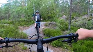
The trail starts quite easy, down from the signs, a tittle section down to a bridge and climb after the bridge, after this long section with short turns with up & down sections, the trail has several drops, but they can be ridden down if you ride them slowly, then you come to a rock surface, after a while, you get to a crossing, then it goes up for a while, with some turns, then a fast downhill.

Tags
BridgesDrops
Local Trail Association

Recent Activity on Trail

Past Week
  • 0 rides
  •  
6 Months
  • 0 rides
  •  
All
  • 6 rides
  • Last: Sep 22, 2025
update trails status or condition

Rælingen Trail Reports

statusdatedescription
Oct 3, 2017 @ 11:24am
Oct 3, 2017
reporter tilpassing av fart er nødvendig, det er mye fått fjell og røtter, og mye gjørme.
more »
Status:
on Oct 3, 2017
Wet
Avg: 4.13 (1 votes)
Your vote: 0

view (17)
close
      Directions to raelingen trailhead (59.642030, 11.178960)

      Photos

      15 more »
      mtb
      25 |
      Jul 2, 2017 @ 3:51pm
      Jul 2, 2017
      mtb
      36 |
      May 30, 2017 @ 9:54am
      May 30, 2017
      mtb
      30 |
      Sep 9, 2021 @ 5:23pm
      Sep 9, 2021
      mtb
      30 |
      Sep 9, 2021 @ 5:19pm
      Sep 9, 2021

      Videos

      1 more »
      Iver Gamre
      mtb
      7:20 | 148 | Jan 17, 2022 , Askim

      Routes with this trail

      ★ 5.0 • 3 miles • 346 ft • 15 • Point to Point •
      Løypa er 5.2 km lang løype, med mange tekniske strekniger, etter du kommer det opp fra grus veien så er...
      5.0 ★★★★★
      1 Ratings
      5 ★ 100%
      4 ★
      3 ★
      2 ★
      1 ★

      Reviews / Comments

      No reviews yet, be the first to write a review or ask a question.
      Use trail reports to comment on trail conditions.


      We hope you've been enjoying Trailforks!

      Create a FREE account to view all trail reviews and much more.

      Frequently Asked Questions

      ▼ Where is Rælingen located?
      Rælingen is located in Åsermarka, Askim, Norway. It is part of the Åsermarka trail network. The trailhead is located at coordinates 59.64203, 11.17896.
      ▼ How hard is Rælingen?
      Rælingen is rated as Red difficulty. The physical rating is Moderate. The average grade is 2.4%. The climb difficulty is rated Blue.
      ▼ What is the elevation gain for Rælingen?
      Rælingen has 14 ft of elevation gain. The trail has 62 ft of elevation descent. The elevation ranges from 651 ft to 708 ft.
      ▼ Is Rælingen a point to point trail?
      Rælingen is not a point to point trail. The direction is Both Directions. The trail type is singletrack.
      ▼ How long is Rælingen?
      Rælingen is 2,008 ft long. The trail type is singletrack.
      ▼ Are dogs allowed on Rælingen?
      Yes, dogs are allowed on Rælingen. Please keep dogs on a leash where required and clean up after them.
      ▼ How do I access Rælingen? Where is the closest parking trailhead?
      The closest parking and trailhead locations to Rælingen are: View all parking locations in the area.
      ▼ How long does it take to ride Rælingen?
      The estimated time to ride Rælingen is approximately 3 minutes. The trail is 2,008 ft long. Actual times will vary based on fitness level, conditions, and pace.
      ▼ How busy is Rælingen?
      Rælingen is a less popular trail with lighter traffic. There have been 17 recorded activities on this trail. The trail has received 17 check-ins. View recent activity on this trail.

      Hit the Trail

      Open in App

      Get this trail on your phone instantly.

      open trail in app

      Download Trail

      Save to wishlist, Garmin & download.
      save the trail

      Find Related Routes

      Find routes and users activities that include this trail.
      find routes for this trail

      You must enter a description before submitting.