
more stats
1.6 miles
Distance
68 ft
Climb
-674 ft
Descent
00:18:29
Avg time
-606 ft
Altitude change
9,254 ft
Altitude min
9,930 ft
Altitude max
9,861 ft
Altitude start
9,255 ft
Altitude end
-7.4%
Grade
-29.5%
Grade max
16.3%
Grade min
1,394 ft
Distance climb
1 mile
Distance down
92 ft
Distance flat
00:18:29
Avg time

Rainbow Pack Station Details

  • Activities
    • Mountain Bike
    • Hike
    • Trail Running
  • Riding Area
    Bishop
    , California
  • Ref Number
    3104A
  • AKA
    Parchers
  • Difficulty Rating
  • Local Popularity
    5 in Mountain Biking [+]
    • 5 in Trail Running
    • 75 in Hiking
  • Global Ranking
    #92346 in Mountain Biking [+]
    • #364456 in Trail Running
    • #63729 in Hiking
  • State Ranking
    #3,139 in Mountain Biking · California [+]
    • #14,620 in Trail Running
    • #3,663 in Hiking
  • Hiking SAC Scale
    T2 Mountain Hiking
  • Trail Type
    Singletrack
  • Bike Type
    DH, AM, XC
  • Dogs Allowed
    Yes

Very technical, rocky descent from South Lake to Parchers Resort. Watch for, and be respectful of horses

Tags
Rocky

Trail Supporters

Local Trail Association

Traditionally Indigenous Territory

Recent Activity on Trail

Past Week
  • 0 rides
  •  
6 Months
  • 0 rides
  •  
All
  • 1 rides
  • Last: Sep 28, 2025
c1c2c3c4
January
February
March
April
May
June
July
August
September
October
November
December
update trails status or condition

Rainbow Pack Station Trail Reports

statusdatedescription
Aug 23, 2020 @ 9:13am
Aug 23, 2020
Jul 2, 2019 @ 4:54pm
Jul 2, 2019
A bit squishy. The Parcher's folks (horseback riders) cleared the trail already. Give them your love if you see them!
Jul 14, 2018 @ 8:53am
Jul 14, 2018
The pack station fixed it up nice after the winter. Looking good after some rain.
more »
Status:
on Aug 23, 2020
Wet
Avg: 4.19 (4 votes)
Your vote: 0

view (33)
close
      Directions to rainbow-pack-station trailhead (37.169850, -118.565550)

      Photos

      2 more »
      hike
      79 |
      Aug 21, 2021 @ 8:15am
      Aug 21, 2021
      hike
      82 |
      Aug 21, 2021 @ 8:15am
      Aug 21, 2021

      Videos

      1 more »
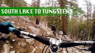
      South Lake to Tungstens | 6,000 ft of descending
      mtb
      3:12 | 839 | Nov 10, 2018 , Bishop

      Routes with this trail

      ★ 5.0 • 27 miles • 3,231 ft • 3 • Shuttled •
      June-September Eastern Sierra Transit offers a shuttle for $5 from Bishop to South Lake:...
      ★ 5.0 • 19 miles • 4,567 ft • 6 • Loop •
      A difficult alpine loop with a long doubletrack climb that takes you above tree line, a couple ups and...

      Trail Products

      4.5 ★★★★★
      4 Ratings
      5 ★ 50%
      4 ★ 50%
      3 ★
      2 ★
      1 ★

      3 Reviews & Comments

      BasedGawd BasedGawd
      Very highly tech, but a much more "rideable" trail than green lake. There are lots of rocky moves and even some sections you can really rail some jank. Few too many foot stairs to be 5*, but it's a fun option if you want to escape the heat of the lower valleys.
      WillieB WillieB
      The good: granite slabs, tech features, fun drops.

      The bad: loads of constructed steps, hoof dust, horse patties.

      It's gnar, and really all but the most hardcore riders probably won't enjoy this trail too much. But nonetheless, a sweet slice of forest + rock tech in an otherwise sandy biking zone. Some cool slabs to ride near the South Lake trailhead too!
      whoisadam
      This trail keeps ya on your toes, posted a video of it under the video tab. 1st part of the video is the Parchers trail, fun stuff.

      We hope you've been enjoying Trailforks!

      Create a FREE account to view all trail reviews and much more.

      • By rickinloTF Pro & contributors
      • #136632 - 1,822 views

      Frequently Asked Questions

      ▼ Where is Rainbow Pack Station located?
      Rainbow Pack Station is located in Bishop, California, United States. It is part of the Bishop trail network. The trailhead is located at coordinates 37.16985, -118.56555.
      ▼ How hard is Rainbow Pack Station?
      Rainbow Pack Station is rated as Double Black Diamond difficulty. The average grade is 7.4%.
      ▼ What is the elevation gain for Rainbow Pack Station?
      Rainbow Pack Station has 68 ft of elevation gain. The trail has 674 ft of elevation descent. The elevation ranges from 9,254 ft to 9,930 ft.
      ▼ How long is Rainbow Pack Station?
      Rainbow Pack Station is 1.6 miles long. The trail type is singletrack.
      ▼ Are dogs allowed on Rainbow Pack Station?
      Yes, dogs are allowed on Rainbow Pack Station. Please keep dogs on a leash where required and clean up after them.
      ▼ How do I access Rainbow Pack Station? Where is the closest parking trailhead?
      The closest parking and trailhead locations to Rainbow Pack Station are: View all parking locations in the area.
      ▼ How long does it take to ride Rainbow Pack Station?
      Based on recorded activities, it takes an average of 32 minutes to ride Rainbow Pack Station. The trail is 1.6 miles long. Actual times will vary based on fitness level, conditions, and pace. View recent activity logs for more details.
      ▼ How busy is Rainbow Pack Station?
      Rainbow Pack Station is a less popular trail with lighter traffic. There have been 33 recorded activities on this trail. The trail has received 33 check-ins. View recent activity on this trail.

      Hit the Trail

      Open in App

      Get this trail on your phone instantly.

      open trail in app

      Download Trail

      Save to wishlist, Garmin & download.
      save the trail

      Find Related Routes

      Find routes and users activities that include this trail.
      find routes for this trail

      You must enter a description before submitting.