more stats
4.1 miles
Distance
453 ft
Climb
-469 ft
Descent
00:30:54
Avg time
-15 ft
Altitude change
1,150 ft
Altitude min
1,447 ft
Altitude max
1,166 ft
Altitude start
1,152 ft
Altitude end
-0.1%
Grade
-20.9%
Grade max
22.1%
Grade min
2 miles
Distance climb
2 miles
Distance down
4,065 ft
Distance flat
00:30:54
Avg time

Raph Details

  • Activities
    • Mountain Bike
    • E-Bike
    • Adaptive Bike
  • Riding Area
    Sentiers du Moulin
    Lac Beauport, Quebec
  • Difficulty Rating
  • Voted Difficulty
    Blue (1 vote)
  • Local Popularity
    90 in Mountain Biking [+]
    • 70 in E-Biking
  • Global Ranking
    #2617 in Mountain Biking [+]
    • #3437 in E-Biking
  • Trail Type
    Singletrack
  • Bike Type
    AM, XC, Adaptive MTB
  • Direction
    One Direction[+]
    • One Direction for E-Biking
  • Climb Difficulty
    Blue
  • Physical Rating
    Moderate
  • Season
    Mai à octobre
  • Family Friendly
    Yes
  • eBike Allowed
    Yes up to Class 1
  • TTFs on Trail
    Bridge
  • Year Opened
    2015
  • Land Owner

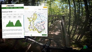
Nommée en l'honneur de Raphael Gagné, cycliste de montagne de Lac-Beauport et Olympien, ce sentier xc de 6 km permet de ceinturer le réseau.

Version 1 - 2015
Gestion de projet et design : Éric Gagnon et Étienne Boileau
Aménagement mécanisé et design : Sentiers Boréals et MTN Évolution
Finition : Équipe de sentiers SDM

Nouvelle version - 2022
Gestion de projet et design : Éric Gagnon et Nicolas Sauvé
Aménagement : Équipe SDM/Velosolutions
Réfection complète du sentier afin d'adoucir les pentes et en faire une piste beaucoup plus accessible plus large, mieux drainé et sans racines et roches.

Adaptive Bike Info
aMTB Green Rating: Beginner features and moderate terrain.
Trail Supporters
  • Desjardins
    2016 - 2018
    Sponsor
  • Velosolutions
    2021 - 2022
    Builder
Local Trail Association
Traditionally Indigenous Territory

Recent Activity on Trail

Past Week
  • 6 rides
  • 20.7 km average
6 Months
  • 72 rides
  • 13.8 km avg distance
All
  • 1,097 rides
  • Last: Jun 5, 2026
c1c2c3c4
January
February
March
April
May
June
July
August
September
October
November
December
Status:
on May 15, 2026
Ideal
Avg: 4.41 (23 votes)
Your vote: 0

view (7,884)
close
3D
Trail Conditions
  • Unknown
  • Snow Groomed
  • Snow Packed
  • Snow Covered
  • Snow Cover Partial
  • Freeze/thaw Cycle
  • Icy
  • Prevalent Mud
  • Wet
  • Variable
  • Ideal
  • Dry
  • Very Dry
Trail Flow (Ridden Direction)
Trailforks scans users ridelogs to determine the most popular direction each trail is ridden. A good flowing trail network will have most trails flowing in a single direction according to their intension.
The colour categories are based on what percentage of riders are riding a trail in its intended direction.
  • > 96%
  • > 90%
  • > 80%
  • > 70%
  • > 50%
  • < 50%
  • bi-directional trail
  • no data
Trail Last Ridden
Trailforks scans ridelogs to determine the last time a trail was ridden.
  • < 2 days
  • < 1 week
  • < 2 weeks
  • < 1 month
  • < 6 months
  • > 6 months
Trail Ridden Direction
The intended direction a trail should be ridden.
  • Downhill Only
  • Downhill Primary
  • Both Directions
  • Uphill Primary
  • Uphill Only
  • One Direction
Contribute Details
Colors indicate trail is missing specified detail.
  • Description
  • Photos
  • Description & Photos
  • Videos
Trail Popularity ?
Trailforks scans ridelogs to determine which trails are ridden the most in the last 9 months. Trails are compared with nearby trails in the same city region with a possible 25 colour shades. Think of this as a heatmap, more rides = more kinetic energy = warmer colors.
  • most popular
  • popular
  • less popular
  • not popular
ATV/ORV/OHV Filter
Max Vehicle Width
inches
US Cell Coverage
Legend
cell carrier legend

Radar Time
Activity Recordings
Trailforks uses anonymized public activity data. ?
Activity Recordings
Trailforks uses anonymized public activity data. ?
Personal Heatmap
Activity Types
all / none
Options
2
Date range month
Winter Trails
Warning A routing network for winter maps does not exist. Selecting trails using the winter trails layer has been disabled.
Missing Trails
Most Popular
Least Popular
Trails are colored based on popularity. The more popular a trail is, the more red. Less popular trails trend towards green.
Jump Magnitude Heatmap
Heatmap of where riders jump on trails. Zoom in to see individual jumps, click circles to view jump details.
BC Backroad Status

Service Road Atlas is a free to use, community-driven service for viewing and creating reports on the numerous back-country service roads around B.C. and Alberta.

map legend
Slope Aspect
Direction the slope faces
Flat N NE E SE S SW W NW
Trails Deemphasized
Trails are shown in grey.
disable
Only show trails with no bike usage.
Enable
Suggested Layers
Based on selected activity type

    Save the current map location and zoom level as your default home location whenever this page is loaded.

    Save
        Directions to raph trailhead (46.984940, -71.268760)

        Photos

        4 more »
        4 |
        May 23, 2026 @ 4:13pm
        May 23, 2026
        160 |
        Sep 25, 2022 @ 4:45pm
        Sep 25, 2022
        166 |
        Sep 25, 2022 @ 4:45pm
        Sep 25, 2022
        169 |
        Jul 7, 2022 @ 1:46pm
        Jul 7, 2022

        Videos

        4 more »
        youtuber ????️ Route POV | 'Green belt' at Sentiers...
        28:08 | 1061 | Jun 21, 2019 , Lac Beauport
        youtuber Raph | Sentiers du Moulin | Quebec City MTB
        2:34 | 2576 | Aug 25, 2017 , Lac Beauport
        La Fabuleuse | Sentiers du Moulin
        10:29 | 164 | Oct 3, 2023 , Lac Beauport
        youtuber Suggestion de pistes ultra-accessible au...
        17:00 | 377 | Sep 22, 2022 , Lac Beauport

        Routes with this trail

        Full Circle Featured
        4.0 9 miles 1,618 ft 8 Loop
        Go full circle at with this challenging route. Expect a bit of everything: classic XC, modern trails, rock...
        5.0 11 miles 2,231 ft 14 Loop
        Enchaînement idéal pour les riders plus expérimentés et amateur de descente. L'idée est d'enchaîner...
        4 miles 455 ft 1 Loop
        The La loop, named in honour of Canadian XC racer Raphael Gagné, is very accessible. The slope is gradual...

        1 Review & Comments


        We hope you've been enjoying Trailforks!

        Create a FREE account to view trail comments and much more.

        • By SentiersduMoulinTF Pro VQ SDM & contributors
        • #39945 - 7,763 views

        Frequently Asked Questions About Raph

        Where is Raph located?
        Raph is located in Sentiers du Moulin, Lac Beauport, Quebec, Canada. It is part of the Sentiers du Moulin trail network. The trailhead is located at coordinates 46.98494, -71.26876.
        How hard is Raph?
        Raph is rated as Green difficulty. The physical rating is Moderate. The average grade is 0.1%. The climb difficulty is rated Blue.
        What is the elevation gain for Raph?
        Raph has 138 m of elevation gain. The trail has 143 m of elevation descent. The elevation ranges from 351 m to 441 m.
        Is Raph a point to point trail?
        Yes, Raph is a point to point trail. The direction is One Direction. The trail type is singletrack.

        Hit the Trail

        Open in App

        Get this trail on your phone instantly.
        open trail in app

        Download Trail

        Save to wishlist, Garmin & download.
        save the trail

        Find Related Routes

        Find routes and users activities that include this trail.
        find routes for this trail

        You must enter a description before submitting.