more stats
1.2 miles
Distance
50 ft
Climb
-51 ft
Descent
00:14:21
Avg time
-2 ft
Altitude change
469 ft
Altitude min
493 ft
Altitude max
470 ft
Altitude start
469 ft
Altitude end
-13.5%
Grade max
9.8%
Grade min
1,099 ft
Distance climb
1,037 ft
Distance down
4,311 ft
Distance flat
00:14:21
Avg time

RCP Loop 14 Details

  • Activities
    • Mountain Bike
    • Hike
    • Trail Running
  • Riding Area
    Rowlett Creek Preserve
    Garland, Texas
  • Difficulty Rating
  • Voted Difficulty
    Black Diamond (6 votes)
  • Local Popularity
    70 in Mountain Biking [+]
    • 70 in Trail Running
    • 75 in Hiking
  • Global Ranking
    #79036 in Mountain Biking [+]
    • #28197 in Trail Running
    • #83979 in Hiking
  • Trail Type
    Singletrack
  • Direction
    One Direction
    Popular Direction Shown
  • Dogs Allowed
    Yes

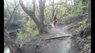
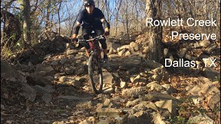
You made it back to Loop 14. Welcome! Are you sure you're not lost? It's a joke, friends. It's a joke. Loop 14 is a world away from RCP's relatively mild field spins. Get ready for roots, chutes, tight turns, and true climbs. This area feeds water into Rowlett Creek, so it's steep in spots. You'll have to traverse the draw twice. Getting across can be a bit tricky due to the armored crossing and steep bank--and when it's damp, whooo-wheee! How good is your fakie game? The draw crossing earns Loop 14 a black diamond rating. You can always walk the creek, if it's just too sketchy.

Local Trail Association
Traditionally Indigenous Territory

Recent Activity on Trail

Past Week
  • 0 rides
  •  
6 Months
  • 31 rides
  • 10 miles avg distance
All
  • 443 rides
  • Last: May 17, 2026
c1c2c3c4
January
February
March
April
May
June
July
August
September
October
November
December
update trails status or condition

RCP Loop 14 Trail Reports

Status:
on May 19, 2026
Prevalent Mud
Avg: 3.64 (8 votes)
Your vote: 0

view (2,322)
close
3D
Trail Conditions
  • Unknown
  • Snow Groomed
  • Snow Packed
  • Snow Covered
  • Snow Cover Partial
  • Freeze/thaw Cycle
  • Icy
  • Prevalent Mud
  • Wet
  • Variable
  • Ideal
  • Dry
  • Very Dry
Trail Flow (Ridden Direction)
Trailforks scans users ridelogs to determine the most popular direction each trail is ridden. A good flowing trail network will have most trails flowing in a single direction according to their intension.
The colour categories are based on what percentage of riders are riding a trail in its intended direction.
  • > 96%
  • > 90%
  • > 80%
  • > 70%
  • > 50%
  • < 50%
  • bi-directional trail
  • no data
Trail Last Ridden
Trailforks scans ridelogs to determine the last time a trail was ridden.
  • < 2 days
  • < 1 week
  • < 2 weeks
  • < 1 month
  • < 6 months
  • > 6 months
Trail Ridden Direction
The intended direction a trail should be ridden.
  • Downhill Only
  • Downhill Primary
  • Both Directions
  • Uphill Primary
  • Uphill Only
  • One Direction
Contribute Details
Colors indicate trail is missing specified detail.
  • Description
  • Photos
  • Description & Photos
  • Videos
Trail Popularity ?
Trailforks scans ridelogs to determine which trails are ridden the most in the last 9 months. Trails are compared with nearby trails in the same city region with a possible 25 colour shades. Think of this as a heatmap, more rides = more kinetic energy = warmer colors.
  • most popular
  • popular
  • less popular
  • not popular
ATV/ORV/OHV Filter
Max Vehicle Width
inches
US Cell Coverage
Legend
cell carrier legend

Radar Time
Activity Recordings
Trailforks uses anonymized public activity data. ?
Activity Recordings
Trailforks uses anonymized public activity data. ?
Personal Heatmap
Activity Types
all / none
Options
2
Date range month
Winter Trails
Warning A routing network for winter maps does not exist. Selecting trails using the winter trails layer has been disabled.
Missing Trails
Most Popular
Least Popular
Trails are colored based on popularity. The more popular a trail is, the more red. Less popular trails trend towards green.
Jump Magnitude Heatmap
Heatmap of where riders jump on trails. Zoom in to see individual jumps, click circles to view jump details.
BC Backroad Status

Service Road Atlas is a free to use, community-driven service for viewing and creating reports on the numerous back-country service roads around B.C. and Alberta.

map legend
Slope Aspect
Direction the slope faces
Flat N NE E SE S SW W NW
Trails Deemphasized
Trails are shown in grey.
disable
Only show trails with no bike usage.
Enable
Suggested Layers
Based on selected activity type

    Save the current map location and zoom level as your default home location whenever this page is loaded.

    Save
        Directions to rcp-loop-14 trailhead (32.928100, -96.601040)

        Photos

        No photos have been added for RCP Loop 14 yet, add a photo.

        Videos

        3 more »
        Trail 14 OWNS Carlos
        0:02 | 179 | Jul 1, 2025 , Garland
        Loop 14 | RCP Full Trail, Mountain Biking
        11:30 | 948 | Oct 21, 2022 , Garland
        Chill Trails and Some Challenges  ||  Rowlett...
        6:26 | 894 | Dec 14, 2020 , Garland

        Routes with this trail

        2.0 16 miles 225 ft 14
        RCP full course all loops included
        2.0 9 miles 183 ft 8 Loop
        All North Loops starting from the North TH near the gun range.
        9 miles 208 ft 9 Loop
        RCP - All of north side. Loops 1, 7, 14, 8,9,13, 12, 11 , 10. 13 and 14 are black

        Reviews / Comments

        No reviews yet, be the first to write a review or ask a question.
        Use trail reports to comment on trail conditions.


        We hope you've been enjoying Trailforks!

        Create a FREE account to view trail comments and much more.

        • By toddTF Pro Trailforks & contributors
        • #118631 - 2,875 views

        Frequently Asked Questions About RCP Loop 14

        Where is RCP Loop 14 located?
        RCP Loop 14 is located in Rowlett Creek Preserve, Garland, Texas, United States. It is part of the Rowlett Creek Preserve trail network. The trailhead is located at coordinates 32.9281, -96.60104.
        How hard is RCP Loop 14?
        RCP Loop 14 is rated as Black Diamond difficulty.
        What is the elevation gain for RCP Loop 14?
        RCP Loop 14 has 50 ft of elevation gain. The trail has 51 ft of elevation descent. The elevation ranges from 469 ft to 493 ft.
        Is RCP Loop 14 a point to point trail?
        Yes, RCP Loop 14 is a point to point trail. The direction is One Direction. The trail type is singletrack.

        Hit the Trail

        Open in App

        Get this trail on your phone instantly.
        open trail in app

        Download Trail

        Save to wishlist, Garmin & download.
        save the trail

        Find Related Routes

        Find routes and users activities that include this trail.
        find routes for this trail

        You must enter a description before submitting.