4,360 ft
Distance
-709 ft
Descent
00:07:04
Avg time

Red Sonja Details

  • Activities
    • Mountain Bike
    • E-Bike
    • Hike
    • Trail Running
    • Snowshoe
  • Riding Area
    Mt Fernie
    Fernie, British Columbia
  • Difficulty Rating
  • Voted Difficulty
    Black Diamond (1 vote)
  • Trail Type
    Singletrack
  • Bike Type
    AM, XC
  • Direction
    Downhill Primary
    Popular direction shown
  • Climb Difficulty
    Black Diamond
  • Physical Rating
    Moderate
  • Season
    May - October
  • Dogs Allowed
    Yes
  • eBike Allowed
    Yes up to Class 1
  • TTFs on Trail
    Jump
  • Global Ranking
    #2448 in Mountain Biking [+]
    • #16927 in E-Biking
    • #6814 in Trail Running
    • #14174 in Hiking
    • #1242 in Snowshoeing
  • Local Popularity
    95 in Mountain Biking [+]
    • 90 in E-Biking
    • 75 in Trail Running
    • 85 in Hiking
    • 90 in Snowshoeing

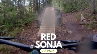
Epic riding - fun, bermy trail back down to Burma Road. Some wooden stunts, including a big launch that gives you the option to jump the gap or ride over the the top.

Access Info

Ride up Phat Bastard onto the powerline and head across as though going to Mushroom Head. Right before the Mushroom Head singletrack starts, the entrance to Red Sonja is immediately on your right.

Local Trail Association
  • trail association logo
  • Please consider joining or donating to the local trail association to support
    trail development & maintenance.
Traditionally Indigenous Territory
More Stats for Red Sonja mountain bike trail trail
  • Altitude change
    -710 ft
  • Altitude min
    3,454 ft
  • Altitude max
    4,164 ft
  • Altitude start
    4,164 ft
  • Altitude end
    3,455 ft
  • Grade
    -16.3%
  • Grade max
    -40.9%
  • Grade min
    -0.8%
  • Distance down
    4,318 ft
  • Distance flat
    39 ft
  • Avg time
    00:07:04
  • Avg reverse time
    00:15:10
  • view trail stats
Status:
on Jan 4, 2023
Dry
Avg: 4.5 (23 votes)
Your vote: 0

view (3,744)
close
3D
Trail Conditions
  • Unknown
  • Snow Groomed
  • Snow Packed
  • Snow Covered
  • Snow Cover Inadequate
  • Freeze/thaw Cycle
  • Icy
  • Prevalent Mud
  • Wet
  • Variable
  • Ideal
  • Dry
  • Very Dry
Trail Flow (Ridden Direction)
Trailforks scans users ridelogs to determine the most popular direction each trail is ridden. A good flowing trail network will have most trails flowing in a single direction according to their intension.
The colour categories are based on what percentage of riders are riding a trail in its intended direction.
  • > 96%
  • > 90%
  • > 80%
  • > 70%
  • > 50%
  • < 50%
  • bi-directional trail
  • no data
Trail Last Ridden
Trailforks scans ridelogs to determine the last time a trail was ridden.
  • < 2 days
  • < 1 week
  • < 2 weeks
  • < 1 month
  • < 6 months
  • > 6 months
Trail Ridden Direction
The intended direction a trail should be ridden.
  • Downhill Only
  • Downhill Primary
  • Both Directions
  • Uphill Primary
  • Uphill Only
  • One Direction
Contribute Details
Colors indicate trail is missing specified detail.
  • Description
  • Photos
  • Description & Photos
  • Videos
Trail Popularity ?
Trailforks scans ridelogs to determine which trails are ridden the most in the last 9 months. Trails are compared with nearby trails in the same city region with a possible 25 colour shades. Think of this as a heatmap, more rides = more kinetic energy = warmer colors.
  • most popular
  • popular
  • less popular
  • not popular
ATV/ORV/OHV Filter
Max Vehicle Width
inches

Radar Time
x Activity Recordings
Trailforks users anonymized public ridelogs from the past 6 months.
  • mountain biking recent
  • mountain biking (>6 month)
  • hiking (1 year)
  • moto (1 year)
Activity Recordings
Trailforks users anonymized public skilogs from the past 12 months.
  • Downhill Ski
  • Backcountry Ski
  • Nordic Ski
  • Snowmobile
Jump Magnitude Heatmap
Heatmap of where riders jump on trails. Zoom in to see individual jumps, click circles to view jump details.
Trails Deemphasized
Trails are shown in grey.
disable
Only show trails with NO bikes.
enable

Save the current map location and zoom level as your default home location whenever this page is loaded.

Save
      Directions to red-sonja trailhead (49.508560, -115.091000)
      update trails status or condition

      Red Sonja Trail Reports

      statusdatedescription
      Jan 4, 2023 @ 2:16am
      Jan 4, 2023
      Good shape!
      Oct 9, 2022 @ 4:04am
      Oct 9, 2022
      Dry dusty with break bumps.
      Aug 23, 2022 @ 7:30pm
      Aug 23, 2022
      Jul 30, 2022 @ 5:49pm
      Jul 30, 2022
      Jun 26, 2022 @ 6:19am
      Jun 26, 2022
      Tree down just past bridge on uphill section. Otherwise good throughout
      view all reports »

      Recent Ridelog Activity on Trail

      Past Week
      • 9 rides
      • 4 miles avg distance
      6 Months
      • 158 rides
      • 7 miles avg distance
      All
      • 3,362 rides
      • Last: Mar 30, 2023

      Photos

      more »
      92 |
      Sep 20, 2020 @ 2:50pm
      Sep 20, 2020
      502 |
      May 20, 2020 @ 10:46am
      May 20, 2020
      157 |
      Apr 9, 2019 @ 4:10pm
      Apr 9, 2019
      88 |
      Dec 16, 2018 @ 12:48pm
      Dec 16, 2018

      Routes with this trail

      more »
      titledistance
      S-Bomb (aka. Slunt)5 miles
      The Guides Hut Trail Recommendation8 miles
      Fernie Brewing Trail to Ale23 miles
      Low Roller 201920 miles

      8 Reviews & Comments


      We hope you've been enjoying Trailforks!

      Create a FREE account to view trail comments and much more.

      Videos

      more »
      Red Sonja - Fernie, BC | Mountain Biking
      5:43 | 1702 | Jun 1, 2018 , Fernie
      Fernie Is Awesome!
      456 | Jun 21, 2017 , Fernie
      Fernie - Trail Master 'Mitchy' in Fernie BC -...
      1:00 | 131 | Jul 19, 2019 , Fernie
      • subscribe
      • flag
      • login to download gpx or kml files.