This trail is permanently closed/decommissioned
more stats
591 ft
Distance
-40 ft
Descent
00:01:02
Avg time
-41 ft
Altitude change
408 ft
Altitude min
448 ft
Altitude max
448 ft
Altitude start
407 ft
Altitude end
-6.9%
Grade
-19.1%
Grade max
-0.4%
Grade min
509 ft
Distance down
82 ft
Distance flat
00:01:02
Avg time

Remastered Details

  • Activities
    • Mountain Bike
    • Hike
    • Trail Running
  • Riding Area
    Riverwood
    Mississauga, Ontario
  • Difficulty Rating
  • Voted Difficulty
    Black Diamond (1 vote)
  • Local Popularity
    45 in Mountain Biking [+]
    • 50 in Trail Running
    • 80 in Hiking
  • Trail Type
    Singletrack
  • Bike Type
    DH, AM, XC
  • Direction
    Downhill Only
    Popular Direction Shown
  • Physical Rating
    Moderate
  • Trail Visibility
    Sometimes hard to follow
  • Dogs Allowed
    Yes
  • TTFs on Trail
    Drop, Jump, Skinny

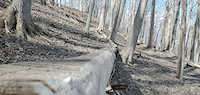
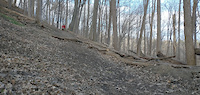
An old school trail recently re-cut. Off camber turns with a few small hits, ending in a step down onto the Culham Trail. Enter off Benchcut DH.

Access Info

Access from Benchcut DH

Local Trail Association

Recent Activity on Trail

Past Week
  • 0 rides
  •  
6 Months
  • 2 rides
  • 11 miles avg distance
All
  • 297 rides
  • Last: May 3, 2026
c1c2c3c4
January
February
March
April
May
June
July
August
September
October
November
December
update trails status or condition

Remastered Trail Reports

statusdatedescription
May 15, 2023 @ 7:08pm
May 15, 2023
still fenced off
Aug 11, 2022 @ 5:02pm
Aug 11, 2022
Riverwood has destroyed the entire trail and piled logs all over, in the name of "restoration"... RIP
Jan 18, 2022 @ 11:59pm
Jan 18, 2022
Nov 9, 2021 @ 10:46pm
Nov 9, 2021
Trail has been cleared of all leaves and debris and is running optimally. Leaves are still falling from the trees.
Nov 3, 2021 @ 4:04pm
Nov 3, 2021
Freshly raked
more »
Status:
on May 15, 2023
Avg: 4.32 (3 votes)
Your vote: 0

view (1,093)
close
3D
Trail Conditions
  • Unknown
  • Snow Groomed
  • Snow Packed
  • Snow Covered
  • Snow Cover Partial
  • Freeze/thaw Cycle
  • Icy
  • Prevalent Mud
  • Wet
  • Variable
  • Ideal
  • Dry
  • Very Dry
Trail Flow (Ridden Direction)
Trailforks scans users ridelogs to determine the most popular direction each trail is ridden. A good flowing trail network will have most trails flowing in a single direction according to their intension.
The colour categories are based on what percentage of riders are riding a trail in its intended direction.
  • > 96%
  • > 90%
  • > 80%
  • > 70%
  • > 50%
  • < 50%
  • bi-directional trail
  • no data
Trail Last Ridden
Trailforks scans ridelogs to determine the last time a trail was ridden.
  • < 2 days
  • < 1 week
  • < 2 weeks
  • < 1 month
  • < 6 months
  • > 6 months
Trail Ridden Direction
The intended direction a trail should be ridden.
  • Downhill Only
  • Downhill Primary
  • Both Directions
  • Uphill Primary
  • Uphill Only
  • One Direction
Contribute Details
Colors indicate trail is missing specified detail.
  • Description
  • Photos
  • Description & Photos
  • Videos
Trail Popularity ?
Trailforks scans ridelogs to determine which trails are ridden the most in the last 9 months. Trails are compared with nearby trails in the same city region with a possible 25 colour shades. Think of this as a heatmap, more rides = more kinetic energy = warmer colors.
  • most popular
  • popular
  • less popular
  • not popular
ATV/ORV/OHV Filter
Max Vehicle Width
inches
US Cell Coverage
Legend
cell carrier legend

Radar Time
Activity Recordings
Trailforks uses anonymized public activity data. ?
Activity Recordings
Trailforks uses anonymized public activity data. ?
Personal Heatmap
Activity Types
all / none
Options
2
Date range month
Winter Trails
Warning A routing network for winter maps does not exist. Selecting trails using the winter trails layer has been disabled.
Missing Trails
Most Popular
Least Popular
Trails are colored based on popularity. The more popular a trail is, the more red. Less popular trails trend towards green.
Jump Magnitude Heatmap
Heatmap of where riders jump on trails. Zoom in to see individual jumps, click circles to view jump details.
BC Backroad Status

Service Road Atlas is a free to use, community-driven service for viewing and creating reports on the numerous back-country service roads around B.C. and Alberta.

map legend
Slope Aspect
Direction the slope faces
Flat N NE E SE S SW W NW
Trails Deemphasized
Trails are shown in grey.
disable
Only show trails with no bike usage.
Enable
Suggested Layers
Based on selected activity type

    Save the current map location and zoom level as your default home location whenever this page is loaded.

    Save
        Directions to remastered trailhead (43.564300, -79.679110)

        Photos

        7 more »
        144 |
        Oct 24, 2021 @ 9:28pm
        Oct 24, 2021
        140 |
        Oct 19, 2021 @ 3:32pm
        Oct 19, 2021
        138 |
        Oct 19, 2021 @ 3:32pm
        Oct 19, 2021
        116 |
        Oct 19, 2021 @ 3:31pm
        Oct 19, 2021

        Videos

        2 more »
        Skinny Offshoot on Remastered
        0:18 | 82 | Jul 17, 2022 , Mississauga
        Remastered Drop to Berm
        0:07 | 76 | Jul 17, 2022 , Mississauga

        Trail Lists

        1 Review & Comments


        We hope you've been enjoying Trailforks!

        Create a FREE account to view trail comments and much more.

        • By gnarcissistTF Pro & contributors
        • #295648 - 1,332 views

        Frequently Asked Questions About Remastered

        Where is Remastered located?
        Remastered is located in Riverwood, Mississauga, Ontario, Canada. It is part of the Riverwood trail network. The trailhead is located at coordinates 43.5643, -79.67911.
        How hard is Remastered?
        Remastered is rated as Black Diamond difficulty. The physical rating is Moderate. The average grade is 6.9%.
        What is the elevation gain for Remastered?
        The trail has 40 ft of elevation descent. The elevation ranges from 408 ft to 448 ft.
        Is Remastered a point to point trail?
        Yes, Remastered is a point to point trail. The direction is Downhill Only. The trail type is singletrack.

        Hit the Trail

        Open in App

        Get this trail on your phone instantly.
        open trail in app

        Download Trail

        Save to wishlist, Garmin & download.
        save the trail

        Find Related Routes

        Find routes and users activities that include this trail.
        find routes for this trail

        You must enter a description before submitting.