more stats
2,274 ft
Distance
34 ft
Climb
-33 ft
Descent
00:03:25
Avg time
0 ft
Altitude change
428 ft
Altitude min
460 ft
Altitude max
459 ft
Altitude start
459 ft
Altitude end
-19%
Grade max
13.8%
Grade min
958 ft
Distance climb
587 ft
Distance down
732 ft
Distance flat
00:03:25
Avg time

Zaichuk Loop Details

  • Activities
    • Mountain Bike
    • Hike
    • Trail Running
  • Riding Area
    Riverwood
    Mississauga, Ontario
  • Difficulty Rating
  • Voted Difficulty
    Blue (2 votes)
  • Local Popularity
    100 in Mountain Biking [+]
    • 85 in Trail Running
    • 5 in Hiking
  • Global Ranking
    #40354 in Mountain Biking [+]
    • #10512 in Trail Running
    • #124548 in Hiking
  • Trail Type
    Singletrack
  • Bike Type
    AM, XC
  • Direction
    Both Directions
  • Climb Difficulty
    Blue
  • Physical Rating
    Moderate
  • Trail Visibility
    Always easy to follow
  • Dogs Allowed
    Yes
  • TTFs on Trail
    Drop, Jump
  • Land Owner

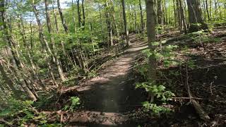
Loop around the old Zaichuk property thats now owned by the City of Mississauga as part of the Riverwood Conservation Area. One of the best loops in the around, great for sessioning.

Access Info

Access from Zaichuk Gravel Climb or Benchcut DH

Local Trail Association

Recent Activity on Trail

Past Week
  • 6 rides
  • 13 miles average
6 Months
  • 60 rides
  • 13 miles avg distance
All
  • 773 rides
  • Last: Jun 30, 2026
c1c2c3c4
January
February
March
April
May
June
July
August
September
October
November
December
update trails status or condition

Zaichuk Loop Trail Reports

statusdatedescription
Apr 8, 2026 @ 9:03am (America/Toronto)
Apr 8, 2026
cleaned and tuned features, trail is mostly dry and ready to ride
Nov 13, 2024 @ 11:37am
Nov 13, 2024
tree down just after Jeffrey's Connector
Jan 7, 2024 @ 12:07pm
Jan 7, 2024
Very snow packed and icy - not suggested to hike up here considering the effort it takes to get down currently (steep).
Jun 8, 2023 @ 7:46pm
Jun 8, 2023
Clear path.
Apr 12, 2023 @ 4:02pm
Apr 12, 2023
Good to go!
more »
Status:
on Apr 8, 2026
Avg: 4.32 (3 votes)
Your vote: 0

view (2,927)
close
3D
Trail Conditions
  • Unknown
  • Snow Groomed
  • Snow Packed
  • Snow Covered
  • Snow Cover Partial
  • Freeze/thaw Cycle
  • Icy
  • Prevalent Mud
  • Wet
  • Variable
  • Ideal
  • Dry
  • Very Dry
Trail Flow (Ridden Direction)
Trailforks scans users ridelogs to determine the most popular direction each trail is ridden. A good flowing trail network will have most trails flowing in a single direction according to their intension.
The colour categories are based on what percentage of riders are riding a trail in its intended direction.
  • > 96%
  • > 90%
  • > 80%
  • > 70%
  • > 50%
  • < 50%
  • bi-directional trail
  • no data
Trail Last Ridden
Trailforks scans ridelogs to determine the last time a trail was ridden.
  • < 2 days
  • < 1 week
  • < 2 weeks
  • < 1 month
  • < 6 months
  • > 6 months
Trail Ridden Direction
The intended direction a trail should be ridden.
  • Downhill Only
  • Downhill Primary
  • Both Directions
  • Uphill Primary
  • Uphill Only
  • One Direction
Contribute Details
Colors indicate trail is missing specified detail.
  • Description
  • Photos
  • Description & Photos
  • Videos
Trail Popularity ?
Trailforks scans ridelogs to determine which trails are ridden the most in the last 9 months. Trails are compared with nearby trails in the same city region with a possible 25 colour shades. Think of this as a heatmap, more rides = more kinetic energy = warmer colors.
  • most popular
  • popular
  • less popular
  • not popular
ATV/ORV/OHV Filter
Max Vehicle Width
inches
US Cell Coverage
Legend
cell carrier legend

Radar Time
Activity Recordings
Trailforks uses anonymized public activity data. ?
Activity Recordings
Trailforks uses anonymized public activity data. ?
Personal Heatmap
Activity Types
all / none
Options
2
Date range month
Winter Trails
Warning A routing network for winter maps does not exist. Selecting trails using the winter trails layer has been disabled.
Missing Trails
Most Popular
Least Popular
Trails are colored based on popularity. The more popular a trail is, the more red. Less popular trails trend towards green.
Jump Magnitude Heatmap
Heatmap of where riders jump on trails. Zoom in to see individual jumps, click circles to view jump details.
BC Backroad Status

Service Road Atlas is a free to use, community-driven service for viewing and creating reports on the numerous back-country service roads around B.C. and Alberta.

map legend
Slope Aspect
Direction the slope faces
Flat N NE E SE S SW W NW
Trails Deemphasized
Trails are shown in grey.
disable
Only show trails with no bike usage.
Enable
Suggested Layers
Based on selected activity type

    Save the current map location and zoom level as your default home location whenever this page is loaded.

    Save
        Directions to zaichuk-loop trailhead (43.565510, -79.678440)

        Photos

        10 more »
        114 |
        Oct 24, 2021 @ 9:31pm
        Oct 24, 2021
        131 |
        Oct 16, 2021 @ 4:13pm
        Oct 16, 2021
        452 |
        Apr 15, 2020 @ 7:28pm
        Apr 15, 2020
        363 |
        Apr 15, 2020 @ 7:23pm
        Apr 15, 2020

        Videos

        1 more »
        Zaichuk Loop
        4:20 | 358 | Oct 2, 2021 , Mississauga

        Trail Lists

        Routes with this trail

        5.0 4,629 ft 31 ft 2 Loop
        The top loop in Riverwood along the 403. Great for sessioning.
        10 miles 707 ft 13 Out & Back
        Park at UTM and Ride into Erindale park and out to Streetsville then back again and up along the ridge...

        Reviews / Comments

        No reviews yet, be the first to write a review or ask a question.
        Use trail reports to comment on trail conditions.


        We hope you've been enjoying Trailforks!

        Create a FREE account to view trail comments and much more.

        • By gnarcissistTF Pro & contributors
        • #224519 - 2,167 views

        Frequently Asked Questions About Zaichuk Loop

        Where is Zaichuk Loop located?
        Zaichuk Loop is located in Riverwood, Mississauga, Ontario, Canada. It is part of the Riverwood trail network. The trailhead is located at coordinates 43.56551, -79.67844.
        How hard is Zaichuk Loop?
        Zaichuk Loop is rated as Blue difficulty. The physical rating is Moderate. The climb difficulty is rated Blue.
        What is the elevation gain for Zaichuk Loop?
        Zaichuk Loop has 10 m of elevation gain. The trail has 10 m of elevation descent. The elevation ranges from 131 m to 140 m.
        Is Zaichuk Loop a point to point trail?
        Zaichuk Loop is not a point to point trail. The direction is Both Directions. The trail type is singletrack.

        Hit the Trail

        Open in App

        Get this trail on your phone instantly.
        open trail in app

        Download Trail

        Save to wishlist, Garmin & download.
        save the trail

        Find Related Routes

        Find routes and users activities that include this trail.
        find routes for this trail

        You must enter a description before submitting.