
more stats
1,509 ft
Distance
3 ft
Climb
-97 ft
Descent
00:06:02
Avg time
-95 ft
Altitude change
628 ft
Altitude min
723 ft
Altitude max
723 ft
Altitude start
627 ft
Altitude end
-6.3%
Grade
-23.4%
Grade max
4.3%
Grade min
69 ft
Distance climb
994 ft
Distance down
446 ft
Distance flat
00:06:02
Avg time

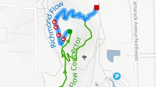
Richmond Flow Details

  • Activities
    • Mountain Bike
    • E-Bike
    • Gravel Bike
    • Winter Fat Bike
    • Hike
    • Trail Running
  • Riding Area
    Richmond Park
    Grand Rapids, Michigan
  • Difficulty Rating
  • Voted Difficulty
    Black Diamond (2 votes)
  • Local Popularity
    85 in Mountain Biking [+]
    • 5 in E-Biking
    • 55 in Trail Running
    • 65 in Hiking
    • 5 in Winter Fat Biking
    • 5 in Gravel Biking
  • Global Ranking
    #43605 in Mountain Biking [+]
    • #142093 in E-Biking
    • #147069 in Trail Running
    • #140148 in Hiking
    • #5105 in Winter Fat Biking
    • #15729 in Gravel Biking
  • State Ranking
    #475 in Mountain Biking · Michigan [+]
    • #817 in E-Biking
    • #1,846 in Trail Running
    • #2,096 in Hiking
    • #119 in Winter Fat Biking
    • #183 in Gravel Biking
  • Trail Type
    Machine Groomed
  • Bike Type
    DH, AM, XC, DJ, Fat, CX, Gravel
  • Direction
    Downhill Only
    Popular Direction Shown
  • Physical Rating
    Moderate
  • Trail Visibility
    Always easy to follow
  • Dogs Allowed
    Yes
  • eBike Allowed
    Yes up to Class 1
  • TTFs on Trail
    Berm, Drop, Jump, Gap Jump
  • Land Owner
    City of Grand Rapids

A fun downhill trail compacted with clay, built by WMMBA volunteers. Very short, but sweet if you have the stamina to climb up for a few laps.

Tags
BermsDropsJumps

Trail Supporters

Local Trail Association

Traditionally Indigenous Territory

Recent Activity on Trail

Past Week
  • 0 rides
  •  
6 Months
  • 4 rides
  • 4 miles avg distance
All
  • 35 rides
  • Last: Oct 25, 2026
c1c2c3c4
January
February
March
April
May
June
July
August
September
October
November
December
update trails status or condition

Richmond Flow Trail Reports

statusdatedescription
Mar 15, 2026 @ 2:10pm (America/Detroit)
Mar 15, 2026
Lower flow trail is still soft with leaf coverage on top
Oct 26, 2025 @ 9:59am (America/Detroit)
Oct 26, 2025
May 5, 2025 @ 4:51pm
May 5, 2025
Apr 11, 2025 @ 7:51pm
Apr 11, 2025
reporter
Trail is riding great! WMMBA volunteer trail day building anew table top jump and tuning up a few landers. Get it while it’s good!
Mar 11, 2025 @ 7:39pm
Mar 11, 2025
reporter
WMMBA trail day, tune up of middle section berm / jumps.
more »
Status:
on Mar 15, 2026
Wet
Avg: 4.24 (2 votes)
Your vote: 0

view (1,300)
close
      Directions to richmond-flow trailhead (42.996350, -85.696460)

      Photos

      34 more »
      mtb
      797 |
      Mar 19, 2025 @ 9:48am
      Mar 19, 2025
      mtb
      159 |
      Mar 19, 2025 @ 9:51am
      Mar 19, 2025
      mtb
      167 |
      Mar 19, 2025 @ 9:50am
      Mar 19, 2025
      mtb
      189 |
      Mar 19, 2025 @ 9:46am
      Mar 19, 2025

      Videos

      3 more »
      Richmond Flow (+connector)
      mtb
      4:48 | 27 | Jul 29, 2026 , Grand Rapids
      Richmond Park
      mtb
      0:10 | 463 | Jul 29, 2019 , Grand Rapids
      Richmond flow trail.
      mtb
      0:32 | 585 | Apr 18, 2017 , Grand Rapids

      Trail Lists

      5.0 ★★★★★
      2 Ratings
      5 ★ 100%
      4 ★
      3 ★
      2 ★
      1 ★

      2 Reviews & Comments

      johnisakson7
      I’d call it more of a black with the gap jumps you gotta be on your toes for. Seriously fun trail tho
      HighBulp HighBulp
      Rode the Flow Trail today. It is an exciting ride, but I need to work on my skill before riding at any kind of decent speed. I am closer to a beginner on the skill level. It was nice that the trail is only a few miles from work.

      We hope you've been enjoying Trailforks!

      Create a FREE account to view all trail reviews and much more.

      • By sissypants & contributors
      • #81993 - 3,391 views

      Frequently Asked Questions

      ▼ Where is Richmond Flow located?
      Richmond Flow is located in Richmond Park, Grand Rapids, Michigan, United States. It is part of the Richmond Park trail network. The trailhead is located at coordinates 42.99635, -85.69646.
      ▼ How hard is Richmond Flow?
      Richmond Flow is rated as Blue difficulty. The physical rating is Moderate. The average grade is 6.3%.
      ▼ What is the elevation gain for Richmond Flow?
      Richmond Flow has 3 ft of elevation gain. The trail has 97 ft of elevation descent. The elevation ranges from 628 ft to 723 ft.
      ▼ Is Richmond Flow a point to point trail?
      Yes, Richmond Flow is a point to point trail. The direction is Downhill Only. The trail type is machine groomed.
      ▼ How long is Richmond Flow?
      Richmond Flow is 1,509 ft long. The trail type is machine groomed.
      ▼ Are dogs allowed on Richmond Flow?
      Yes, dogs are allowed on Richmond Flow. Please keep dogs on a leash where required and clean up after them.
      ▼ When is the best time of year to ride Richmond Flow?
      Based on activity log data, the most popular months to ride Richmond Flow are:
      • July (5 activities)
      • March (4 activities)
      • October (3 activities)
      Check the reports page for current trail conditions.
      ▼ How do I access Richmond Flow? Where is the closest parking trailhead?
      The closest parking and trailhead locations to Richmond Flow are: View all parking locations in the area.
      ▼ How long does it take to ride Richmond Flow?
      Based on recorded activities, it takes an average of 6 minutes to ride Richmond Flow. The trail is 1,509 ft long. Actual times will vary based on fitness level, conditions, and pace. View recent activity logs for more details.
      ▼ How busy is Richmond Flow?
      Richmond Flow is a very popular trail. There have been 879 recorded activities on this trail. The trail has received 1,300 check-ins. View recent activity on this trail.

      Hit the Trail

      Open in App

      Get this trail on your phone instantly.

      open trail in app

      Download Trail

      Save to wishlist, Garmin & download.
      save the trail

      Find Related Routes

      Find routes and users activities that include this trail.
      find routes for this trail

      You must enter a description before submitting.