1.3 miles
Distance
7 ft
Climb
-1,029 ft
Descent
00:17:37
Avg time
Rick Rolled Details
-
Activities
- Mountain Bike
- E-Bike
-
Riding AreaBlanchard Mountain
Bellingham, Washington -
AKARandy Slappage
-
Difficulty Rating
-
Voted DifficultyBlack Diamond (6 votes)
-
Trail TypeSingletrack
-
DirectionDownhill OnlyPopular direction shown
-
Trail VisibilityAlways easy to follow
-
Dogs AllowedYes
-
eBike AllowedYes up to Class 1
-
Local Popularity70 in Mountain Biking [+]
- 55 in E-Biking
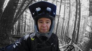
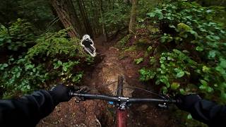
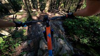
Rick Rolled, aka Randy Slappage has opened as a legal DNR approved public trail. Props to the builders and to the DNR
Local Trail Association
-
Please consider joining or donating to the local trail association to supportdonate to earn trail karma!
trail development & maintenance.
More Stats for Rick Rolled mountain bike trail trail
-
Altitude change-1,022 ft
-
Altitude min982 ft
-
Altitude max2,009 ft
-
Altitude start2,005 ft
-
Altitude end981 ft
-
Grade-15.5%
-
Grade max-41%
-
Grade min6.6%
-
Distance climb213 ft
-
Distance down1 mile
-
Distance flat443 ft
-
Avg time00:17:37
- view trail stats
close
3D
Trail Conditions
- Unknown
- Snow Groomed
- Snow Packed
- Snow Covered
- Snow Cover Partial
- Freeze/thaw Cycle
- Icy
- Prevalent Mud
- Wet
- Variable
- Ideal
- Dry
- Very Dry
Trail Flow (Ridden Direction)
Trailforks scans users ridelogs to determine the most popular direction each trail is ridden. A good flowing trail network will have most trails flowing in a single direction according to their intension.
The colour categories are based on what percentage of riders are riding a trail in its intended direction.
- > 96%
- > 90%
- > 80%
- > 70%
- > 50%
- < 50%
- bi-directional trail
- no data
Trail Last Ridden
Trailforks scans ridelogs to determine the last time a trail was ridden.
- < 2 days
- < 1 week
- < 2 weeks
- < 1 month
- < 6 months
- > 6 months
Trail Ridden Direction
The intended direction a trail should be ridden.
- Downhill Only
- Downhill Primary
- Both Directions
- Uphill Primary
- Uphill Only
- One Direction
Contribute Details
Colors indicate trail is missing specified detail.
- Description
- Photos
- Description & Photos
- Videos
Trail Popularity ?
Trailforks scans ridelogs to determine which trails are ridden the most in the last 9 months.
Trails are compared with nearby trails in the same city region with a possible 25 colour shades.
Think of this as a heatmap, more rides = more kinetic energy = warmer colors.
- most popular
- popular
- less popular
- not popular
ATV/ORV/OHV Filter
Max Vehicle Width
inches
US Cell Coverage
Legend
Radar Time
x
Activity Recordings
Trailforks users anonymized public ridelogs from the past 6 months.
- mountain biking recent
- mountain biking (>6 month)
- hiking (1 year)
- moto (1 year)
Activity Recordings
Trailforks users anonymized public skilogs from the past 12 months.
- Downhill Ski
- Backcountry Ski
- Nordic Ski
- Snowmobile
Winter Trails
Warning
A routing network for winter maps does not exist. Selecting trails using the winter trails layer has been disabled.
x
Missing Trails
Most Popular
Least Popular
Trails are colored based on popularity. The more popular a trail is, the more red. Less popular trails trend towards green.
Jump Magnitude Heatmap
Heatmap of where riders jump on trails. Zoom in to see individual jumps, click circles to view jump details.
Trails Deemphasized
Trails are shown in grey.
Only show trails with NO bikes.
Save the current map location and zoom level as your default home location whenever this page is loaded.
Save
Directions to rick-rolled trailhead
(48.625300, -122.398910)
update trails status or condition
Rick Rolled Trail Reports
view all reports »
Recent Ridelog Activity on Trail
Past Week
- 0 rides
6 Months
- 47 rides
- 9 miles avg distance
All
- 160 rides
- Last: Feb 5, 2025
Photos
more »
Trail Lists
-
Bellingham Tech
28 trails
Routes with this trail
Trail Products
8 Reviews & Comments
We hope you've been enjoying Trailforks!
Create a FREE account to view trail comments and much more.
Videos
more »
Nearby Trails
- Lilly, Lizard Lake Trail 2,707 ft
- Lilly Lizard Connector 2,707 ft
- The Horn 2,972 ft
- Oyster Dome 3,045 ft
- Alternate Incline 3,707 ft
- By jjaap
WMBC & contributors
- #443997 - 3,853 views
- follow/subscribe
- login to download gpx or kml files.
You must enter a description before submitting.