more stats
1,198 ft
Distance
8 ft
Climb
-126 ft
Descent
00:12:47
Avg time
-118 ft
Altitude change
958 ft
Altitude min
1,086 ft
Altitude max
1,076 ft
Altitude start
958 ft
Altitude end
-9.8%
Grade
-30.2%
Grade max
11.4%
Grade min
131 ft
Distance climb
958 ft
Distance down
108 ft
Distance flat
00:12:47
Avg time

Rickshaw Details

  • Activities
    • Mountain Bike
    • Hike
    • Trail Running
  • Riding Area
    Thickwood River Valley
    Fort McMurray, Alberta
  • Difficulty Rating
  • Local Popularity
    30 in Mountain Biking [+]
    • 5 in Trail Running
    • 90 in Hiking
  • Global Ranking
    #230744 in Mountain Biking [+]
    • #311619 in Trail Running
    • #48644 in Hiking
  • Trail Type
    Singletrack
  • Bike Type
    DH, AM, XC
  • Direction
    Downhill Primary
  • Physical Rating
    Hard
  • Season
    Late May-it snows
  • Dogs Allowed
    Yes
  • TTFs on Trail
    Berm, Drop, Jump, Gap Jump, Ladder Bridge, Log Ride, Skinny
  • Year Opened
    2016

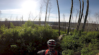
Rickshaw features several Technical Trail Features (TTFs), including logs rides, a linear take-off gap jump, a step-up/step-down platform jump, and some technical turns. All gap features can be ridden around and are not mandatory. Enjoy this short stretch of unique trail as you make your way down to the Edge

Not recommended when trail is wet. The clay is very sticky and slick.

Access Info

Head to the junction where Halfway to the Edge starts going down the hill. Rickshaw begins to the left of the junction.

Recent Activity on Trail

Past Week
  • 0 rides
  •  
6 Months
  • 1 rides
  • 6 miles avg distance
All
  • 28 rides
  • Last: Jun 2, 2026
c1c2c3c4
January
February
March
April
May
June
July
August
September
October
November
December
update trails status or condition

Rickshaw Trail Reports

statusdatedescription
Jun 18, 2026 @ 2:37pm (America/Edmonton)
Jun 18, 2026
landslide near end fix thing all trees cut
Oct 15, 2025 @ 10:28am (America/Los_Angeles)
Oct 15, 2025
bridge down area under construction digger needed.also chain saw miller
Jul 22, 2025 @ 1:28pm
Jul 22, 2025
did little weeding with shovel walk around nice job on the persons that hit the trail with cutter ,clean up some the ciutting on rich shaw , lady...
Jun 16, 2025 @ 5:15pm
Jun 16, 2025
Log jump at the end is down. Chainsaw battery died … will finish Tomorrow or Wednesday
Jun 11, 2025 @ 9:45am
Jun 11, 2025
Everthing open just seen big moose track running around like a crazy horse ,,just a head up
more »
Status:
on Jun 18, 2026
Avg: 5 (1 votes)
Your vote: 0

view (75)
close
3D
Trail Conditions
  • Unknown
  • Snow Groomed
  • Snow Packed
  • Snow Covered
  • Snow Cover Partial
  • Freeze/thaw Cycle
  • Icy
  • Prevalent Mud
  • Wet
  • Variable
  • Ideal
  • Dry
  • Very Dry
Trail Flow (Ridden Direction)
Trailforks scans users ridelogs to determine the most popular direction each trail is ridden. A good flowing trail network will have most trails flowing in a single direction according to their intension.
The colour categories are based on what percentage of riders are riding a trail in its intended direction.
  • > 96%
  • > 90%
  • > 80%
  • > 70%
  • > 50%
  • < 50%
  • bi-directional trail
  • no data
Trail Last Ridden
Trailforks scans ridelogs to determine the last time a trail was ridden.
  • < 2 days
  • < 1 week
  • < 2 weeks
  • < 1 month
  • < 6 months
  • > 6 months
Trail Ridden Direction
The intended direction a trail should be ridden.
  • Downhill Only
  • Downhill Primary
  • Both Directions
  • Uphill Primary
  • Uphill Only
  • One Direction
Contribute Details
Colors indicate trail is missing specified detail.
  • Description
  • Photos
  • Description & Photos
  • Videos
Trail Popularity ?
Trailforks scans ridelogs to determine which trails are ridden the most in the last 9 months. Trails are compared with nearby trails in the same city region with a possible 25 colour shades. Think of this as a heatmap, more rides = more kinetic energy = warmer colors.
  • most popular
  • popular
  • less popular
  • not popular
ATV/ORV/OHV Filter
Max Vehicle Width
inches
US Cell Coverage
Legend
cell carrier legend

Radar Time
Activity Recordings
Trailforks uses anonymized public activity data. ?
Activity Recordings
Trailforks uses anonymized public activity data. ?
Personal Heatmap
Activity Types
all / none
Options
2
Date range month
Winter Trails
Warning A routing network for winter maps does not exist. Selecting trails using the winter trails layer has been disabled.
Missing Trails
Most Popular
Least Popular
Trails are colored based on popularity. The more popular a trail is, the more red. Less popular trails trend towards green.
Jump Magnitude Heatmap
Heatmap of where riders jump on trails. Zoom in to see individual jumps, click circles to view jump details.
BC Backroad Status

Service Road Atlas is a free to use, community-driven service for viewing and creating reports on the numerous back-country service roads around B.C. and Alberta.

map legend
Slope Aspect
Direction the slope faces
Flat N NE E SE S SW W NW
Trails Deemphasized
Trails are shown in grey.
disable
Only show trails with no bike usage.
Enable
Suggested Layers
Based on selected activity type

    Save the current map location and zoom level as your default home location whenever this page is loaded.

    Save
        Directions to rickshaw trailhead (56.723530, -111.419430)

        Photos

        49 more »
        27 |
        Jun 20, 2024 @ 8:43pm
        Jun 20, 2024
        25 |
        Jun 20, 2024 @ 8:43pm
        Jun 20, 2024
        25 |
        Jun 20, 2024 @ 8:43pm
        Jun 20, 2024
        28 |
        Jun 20, 2024 @ 8:43pm
        Jun 20, 2024

        Videos

        1 more »
        Rickshaw backpack mount POV
        0:07 | 366 | Jul 17, 2018 , Fort McMurray

        1 Review & Comments


        We hope you've been enjoying Trailforks!

        Create a FREE account to view trail comments and much more.

        • By juicebangerTF Pro FMCA & contributors
        • #93792 - 1,394 views

        Frequently Asked Questions About Rickshaw

        Where is Rickshaw located?
        Rickshaw is located in Thickwood River Valley, Fort McMurray, Alberta, Canada. It is part of the Thickwood River Valley trail network. The trailhead is located at coordinates 56.72353, -111.41943.
        How hard is Rickshaw?
        Rickshaw is rated as Black Diamond difficulty. The physical rating is Hard. The average grade is 9.8%.
        What is the elevation gain for Rickshaw?
        Rickshaw has 2 m of elevation gain. The trail has 38 m of elevation descent. The elevation ranges from 292 m to 331 m.
        Is Rickshaw a point to point trail?
        Rickshaw is not a point to point trail. The direction is Downhill Primary. The trail type is singletrack.

        Hit the Trail

        Open in App

        Get this trail on your phone instantly.
        open trail in app

        Download Trail

        Save to wishlist, Garmin & download.
        save the trail

        Find Related Routes

        Find routes and users activities that include this trail.
        find routes for this trail

        You must enter a description before submitting.