more stats
2.3 miles
Distance
220 ft
Climb
-542 ft
Descent
00:13:16
Avg time
-323 ft
Altitude change
589 ft
Altitude min
912 ft
Altitude max
912 ft
Altitude start
591 ft
Altitude end
-2.6%
Grade
-27.2%
Grade max
20.2%
Grade min
3,307 ft
Distance climb
1 mile
Distance down
1,768 ft
Distance flat
00:13:16
Avg time

Ripple Effect Details

  • Activities
    • Mountain Bike
    • E-Bike
  • Riding Area
  • Difficulty Rating
  • Local Popularity
    75 in Mountain Biking [+]
    • 75 in E-Biking
  • Global Ranking
    #44302 in Mountain Biking [+]
    • #40521 in E-Biking
  • Trail Type
    Singletrack
  • Bike Type
    XC
  • Direction
    One Direction
    Popular Direction Shown
  • Climb Difficulty
    Green
  • Physical Rating
    Moderate
  • eBike Allowed
    Yes up to Class 1
  • TTFs on Trail
    Berm, Bridge, Jump, Roller Coaster
  • Year Opened
    2015

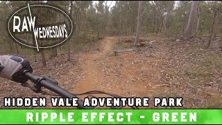
A great flow track from the top to the bottom..a bit of work to keep the speed up on the upper part with great run speed on the last half of the track....some good features with jumps & drop offs(with chicken loops for the faint hearted)....finishing at the junction of Big Dam,fairy wren & dinner camp.

Bike Park

Local Trail Association
Traditionally Indigenous Territory

Recent Activity on Trail

Past Week
  • 0 rides
  •  
6 Months
  • 8 rides
  • 16 miles avg distance
All
  • 234 rides
  • Last: May 30, 2026
c1c2c3c4
January
February
March
April
May
June
July
August
September
October
November
December
update trails status or condition

Ripple Effect Trail Reports

statusdatedescription
Jul 5, 2024 @ 3:25pm
Jul 5, 2024
trail is running well
Aug 20, 2023 @ 4:01am
Aug 20, 2023
Jul 2, 2023 @ 1:37am
Jul 2, 2023
Apr 16, 2022 @ 12:09am
Apr 16, 2022
Some top section over grown, bottom sections where track skirts water gully has some significant side cave ins and trees and sticks sticking into...
Sep 4, 2021 @ 4:32pm
Sep 4, 2021
more »
Status:
on Jul 5, 2024
Ideal
Avg: 4.42 (8 votes)
Your vote: 0

view (1,517)
close
3D
Trail Conditions
  • Unknown
  • Snow Groomed
  • Snow Packed
  • Snow Covered
  • Snow Cover Partial
  • Freeze/thaw Cycle
  • Icy
  • Prevalent Mud
  • Wet
  • Variable
  • Ideal
  • Dry
  • Very Dry
Trail Flow (Ridden Direction)
Trailforks scans users ridelogs to determine the most popular direction each trail is ridden. A good flowing trail network will have most trails flowing in a single direction according to their intension.
The colour categories are based on what percentage of riders are riding a trail in its intended direction.
  • > 96%
  • > 90%
  • > 80%
  • > 70%
  • > 50%
  • < 50%
  • bi-directional trail
  • no data
Trail Last Ridden
Trailforks scans ridelogs to determine the last time a trail was ridden.
  • < 2 days
  • < 1 week
  • < 2 weeks
  • < 1 month
  • < 6 months
  • > 6 months
Trail Ridden Direction
The intended direction a trail should be ridden.
  • Downhill Only
  • Downhill Primary
  • Both Directions
  • Uphill Primary
  • Uphill Only
  • One Direction
Contribute Details
Colors indicate trail is missing specified detail.
  • Description
  • Photos
  • Description & Photos
  • Videos
Trail Popularity ?
Trailforks scans ridelogs to determine which trails are ridden the most in the last 9 months. Trails are compared with nearby trails in the same city region with a possible 25 colour shades. Think of this as a heatmap, more rides = more kinetic energy = warmer colors.
  • most popular
  • popular
  • less popular
  • not popular
ATV/ORV/OHV Filter
Max Vehicle Width
inches
US Cell Coverage
Legend
cell carrier legend

Radar Time
Activity Recordings
Trailforks uses anonymized public activity data. ?
Activity Recordings
Trailforks uses anonymized public activity data. ?
Personal Heatmap
Activity Types
all / none
Options
2
Date range month
Winter Trails
Warning A routing network for winter maps does not exist. Selecting trails using the winter trails layer has been disabled.
Missing Trails
Most Popular
Least Popular
Trails are colored based on popularity. The more popular a trail is, the more red. Less popular trails trend towards green.
Jump Magnitude Heatmap
Heatmap of where riders jump on trails. Zoom in to see individual jumps, click circles to view jump details.
BC Backroad Status

Service Road Atlas is a free to use, community-driven service for viewing and creating reports on the numerous back-country service roads around B.C. and Alberta.

map legend
Slope Aspect
Direction the slope faces
Flat N NE E SE S SW W NW
Trails Deemphasized
Trails are shown in grey.
disable
Only show trails with no bike usage.
Enable
Suggested Layers
Based on selected activity type

    Save the current map location and zoom level as your default home location whenever this page is loaded.

    Save
        Directions to ripple-effect trailhead (-27.743620, 152.428140)

        Photos

        2 more »
        106 |
        Mar 21, 2019 @ 7:23pm
        Mar 21, 2019
        95 |
        Mar 21, 2019 @ 7:23pm
        Mar 21, 2019

        Videos

        1 more »
        youtuber RIPPLE EFFECT | HVAP | RAW WEDNESDAYS
        11:23 | 426 | May 12, 2022 , Ipswich

        Routes with this trail

        5.0 55 miles 6,894 ft 15 Loop
        test test test test test test
        2.0 33 miles 4,570 ft 15 Loop
        2025 53km Chaser, Half at HVAP
        14 miles 1,403 ft 8 Loop
        HVAP green arrow loop. Great to those looking to explore a little further out. Follow the green arrows for...

        Reviews / Comments

        No reviews yet, be the first to write a review or ask a question.
        Use trail reports to comment on trail conditions.


        We hope you've been enjoying Trailforks!

        Create a FREE account to view trail comments and much more.

        • By haydenbrooksTF Pro HVAP & contributors
        • #55440 - 4,194 views

        Frequently Asked Questions About Ripple Effect

        Where is Ripple Effect located?
        Ripple Effect is located in Hidden Vale Adventure Park, Ipswich, Australia. It is part of the Hidden Vale Adventure Park trail network. The trailhead is located at coordinates -27.74362, 152.42814.
        How hard is Ripple Effect?
        Ripple Effect is rated as Green difficulty. The physical rating is Moderate. The average grade is 2.6%. The climb difficulty is rated Green.
        What is the elevation gain for Ripple Effect?
        Ripple Effect has 67 m of elevation gain. The trail has 165 m of elevation descent. The elevation ranges from 180 m to 278 m.
        Is Ripple Effect a point to point trail?
        Yes, Ripple Effect is a point to point trail. The direction is One Direction. The trail type is singletrack.

        Hit the Trail

        Open in App

        Get this trail on your phone instantly.
        open trail in app

        Download Trail

        Save to wishlist, Garmin & download.
        save the trail

        Find Related Routes

        Find routes and users activities that include this trail.
        find routes for this trail

        You must enter a description before submitting.