more stats
2.5 miles
Distance
87 ft
Climb
-687 ft
Descent
1,829 ft
High Point
-600 ft
Altitude change
1,229 ft
Altitude min
1,829 ft
Altitude start
1,230 ft
Altitude end
-4.6%
Grade
-32.5%
Grade max
8.1%
Grade min
2,959 ft
Distance climb
2 miles
Distance down
1,240 ft
Distance flat

Saga Details

  • Activities
    • Mountain Bike
    • E-Bike
  • Riding Area
    Sentiers du Moulin
    Lac Beauport, Quebec
  • AKA
    Maléfique, Ère de glace
  • Difficulty Rating
  • Voted Difficulty
    Double Black Diamond (2 votes)
  • Local Popularity
    95 in Mountain Biking [+]
    • 90 in E-Biking
  • Blaze Color
  • Trail Type
    Singletrack
  • Bike Type
    AM, XC
  • Direction
    One Direction[+]
    Popular Direction Shown
    • One Direction for E-Biking
  • Climb Difficulty
    Black Diamond
  • Physical Rating
    Hard
  • Trail Visibility
    Always easy to follow
  • Season
    Mai à septembre
  • eBike Allowed
    Yes up to Class 1
  • TTFs on Trail
    Bridge, Ladder Bridge, Log Ride, Rock Face, Rock Garden, Skinny
  • Year Opened
    2025
  • Land Owner

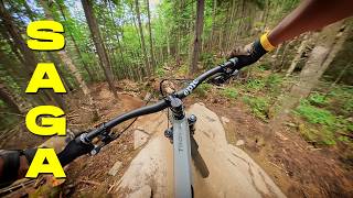
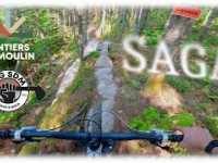
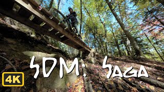
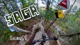
Le plus ambitieux projet de SDM à ce jour. Un sentier d’aventure (all-mountain) façonné à la main et à la pelle mécanique dans un terrain brut, technique et spectaculaire. Parois rocheuses, dalles, tunnel, crêtes exposées, tapis de mousse verte et paliers naturels… chaque section de Saga raconte un chapitre d'une odyssée façonnée par la nature et le temps.

Ce projet représente le plus grand défi d’aménagement jamais réalisé à SDM. En plus des 2 000 heures investies par l’équipe terrain, plus de 2 000 heures de bénévolat ont été consacrées par les infatigables de DigSDM, notamment pour aménager à la main de longues sections inaccessibles à la pelle mécanique.

Chaque ligne a été pensée, ajustée et sculptée avec minutie, dans une approche minimaliste et respectueuse de la nature environnante. Le résultat : un des sentiers les plus aboutis de notre réseau, tant sur le plan technique qu’esthétique. Une ligne signature, taillée dans le temps, portée par une communauté engagée.

Remerciements
Merci à Pat Dorion pour son travail chirurgical à la pelle mécanique, à l’équipe terrain de SDM pour son implication exceptionnelle, aux propriétaires fonciers qui nous donnent accès à ce joyau 100 % en droit de passage, et à tous les bénévoles de DigSDM qui ont porté ce projet avec passion.

Crédits
Gestion de projet : Éric Gagnon
Design : Éric Gagnon & Nicolas Sauvé avec l’aide de JP Anctil, Steeve Houde et Julien Lévesque-Boulianne
Leaders bénévoles : JP Anctil, Steeve Houde, Étienne Boileau, JF Godin et Pol Reny
Aménagement mécanisé : Patrice Dorion – MTN Évolution
Finition : Équipe de sentiers SDM & DigSDM


Reconnaissance internationale

En 2025, Saga a été nommé meilleur sentier technique de l’année en Amérique du Nord par Singletracks, dans leur article "9 of the Best Mountain Bike Trails Built in North America in 2025”.
Une reconnaissance majeure qui souligne l’excellence du design, la maîtrise technique du terrain et l’approche minimaliste et respectueuse de l’environnement ayant guidé ce projet d’exception.

www.singletracks.com/mtb-trails/9-of-the-best-mountain-bike-trails-built-in-north-america-in-2025
---------------------------------------------------------------------------

SDM’s most ambitious project to date. An all-mountain trail, hand-built and machine-shaped, through rugged, technical, and spectacular terrain. Rock faces, slabs, a tunnel, exposed ridgelines, carpets of green moss, and natural ledges… each section of Saga tells a chapter of an odyssey shaped by nature and time.

This project represents the greatest trailbuilding challenge ever undertaken at SDM. In addition to the 2,000 hours invested by the trail crew, more than 2,000 volunteer hours were contributed by the tireless DigSDM team, notably to handcraft long sections inaccessible to machinery.

Every line was carefully planned, adjusted, and sculpted with precision, following a minimalist approach that respects the surrounding environment. The result: one of the most refined trails in our network, combining technical depth and aesthetic beauty. A signature line, carved through time, brought to life by a passionate community.

Acknowledgments
Thanks to Pat Dorion for his surgical work with the excavator, to SDM’s trail crew for their exceptional commitment, to the landowners who grant us access to this 100% legal gem, and to all the DigSDM volunteers who carried this project with passion.

Credits
Project management: Éric Gagnon
Design: Éric Gagnon & Nicolas Sauvé, with the help of JP Anctil, Steeve Houde and Julien Lévesque-Boulianne
Volunteer leaders: JP Anctil, Steeve Houde, Étienne Boileau, JF Godin and Pol Reny
Machine work: Patrice Dorion – MTN Évolution
Finishing: SDM Trail Crew & DigSDM


International Recognition
In 2025, Saga was named the best technical mountain bike trail of the year in North America by Singletracks, in their article “9 of the Best Mountain Bike Trails Built in North America in 2025”.
This major recognition highlights the excellence of the trail’s design, the technical mastery of the terrain, and the minimalist, nature-respecting approach that guided this exceptional project.

www.singletracks.com/mtb-trails/9-of-the-best-mountain-bike-trails-built-in-north-america-in-2025

Local Trail Association
Traditionally Indigenous Territory

Recent Activity on Trail

Past Week
  • 18 rides
  • 11 miles average
6 Months
  • 62 rides
  • 12 miles avg distance
All
  • 451 rides
  • Last: Jun 29, 2026
c1c2c3c4
January
February
March
April
May
June
July
August
September
October
November
December
Status:
on May 29, 2026
Ideal
Avg: 4.39 (9 votes)
Your vote: 0

view (2,039)
close
3D
Trail Conditions
  • Unknown
  • Snow Groomed
  • Snow Packed
  • Snow Covered
  • Snow Cover Partial
  • Freeze/thaw Cycle
  • Icy
  • Prevalent Mud
  • Wet
  • Variable
  • Ideal
  • Dry
  • Very Dry
Trail Flow (Ridden Direction)
Trailforks scans users ridelogs to determine the most popular direction each trail is ridden. A good flowing trail network will have most trails flowing in a single direction according to their intension.
The colour categories are based on what percentage of riders are riding a trail in its intended direction.
  • > 96%
  • > 90%
  • > 80%
  • > 70%
  • > 50%
  • < 50%
  • bi-directional trail
  • no data
Trail Last Ridden
Trailforks scans ridelogs to determine the last time a trail was ridden.
  • < 2 days
  • < 1 week
  • < 2 weeks
  • < 1 month
  • < 6 months
  • > 6 months
Trail Ridden Direction
The intended direction a trail should be ridden.
  • Downhill Only
  • Downhill Primary
  • Both Directions
  • Uphill Primary
  • Uphill Only
  • One Direction
Contribute Details
Colors indicate trail is missing specified detail.
  • Description
  • Photos
  • Description & Photos
  • Videos
Trail Popularity ?
Trailforks scans ridelogs to determine which trails are ridden the most in the last 9 months. Trails are compared with nearby trails in the same city region with a possible 25 colour shades. Think of this as a heatmap, more rides = more kinetic energy = warmer colors.
  • most popular
  • popular
  • less popular
  • not popular
ATV/ORV/OHV Filter
Max Vehicle Width
inches
US Cell Coverage
Legend
cell carrier legend

Radar Time
Activity Recordings
Trailforks uses anonymized public activity data. ?
Activity Recordings
Trailforks uses anonymized public activity data. ?
Personal Heatmap
Activity Types
all / none
Options
2
Date range month
Winter Trails
Warning A routing network for winter maps does not exist. Selecting trails using the winter trails layer has been disabled.
Missing Trails
Most Popular
Least Popular
Trails are colored based on popularity. The more popular a trail is, the more red. Less popular trails trend towards green.
Jump Magnitude Heatmap
Heatmap of where riders jump on trails. Zoom in to see individual jumps, click circles to view jump details.
BC Backroad Status

Service Road Atlas is a free to use, community-driven service for viewing and creating reports on the numerous back-country service roads around B.C. and Alberta.

map legend
Slope Aspect
Direction the slope faces
Flat N NE E SE S SW W NW
Trails Deemphasized
Trails are shown in grey.
disable
Only show trails with no bike usage.
Enable
Suggested Layers
Based on selected activity type

    Save the current map location and zoom level as your default home location whenever this page is loaded.

    Save
        Directions to saga trailhead (46.979040, -71.251590)

        Photos

        44 more »
        3 |
        Jun 29, 2026 @ 7:39am
        Jun 29, 2026
        2 |
        Jun 29, 2026 @ 7:39am
        Jun 29, 2026
        4 |
        Jun 29, 2026 @ 7:39am
        Jun 29, 2026
        76 |
        Oct 23, 2025 @ 5:27pm
        Oct 23, 2025

        Videos

        10 more »
        youtuber ‍♂️ Saga – Le nouveau sentier...
        22:22 | 410 | Jul 3, 2025 , Lac Beauport
        youtuber SENTIERS DU MOULIN - SAGA - NEW TRACK
        297 | Jun 20, 2025 , Lac Beauport
        SDM Saga Mountain Bike
        3:54 | 74 | Oct 8, 2025 , Lac Beauport
        SAGA, sentiers du moulin (full POV)
        16:50 | 60 | Sep 18, 2025 , Lac Beauport

        5 Reviews & Comments


        We hope you've been enjoying Trailforks!

        Create a FREE account to view trail comments and much more.

        • By SentiersduMoulinTF Pro VQ SDM & contributors
        • #324247 - 2,482 views

        Frequently Asked Questions About Saga

        Where is Saga located?
        Saga is located in Sentiers du Moulin, Lac Beauport, Quebec, Canada. It is part of the Sentiers du Moulin trail network. The trailhead is located at coordinates 46.97904, -71.25159.
        How hard is Saga?
        Saga is rated as Black Diamond difficulty. The physical rating is Hard. The average grade is 4.6%. The climb difficulty is rated Black Diamond.
        What is the elevation gain for Saga?
        Saga has 87 ft of elevation gain. The trail has 687 ft of elevation descent. The elevation ranges from 1,229 ft to 1,829 ft.
        Is Saga a point to point trail?
        Yes, Saga is a point to point trail. The direction is One Direction. The trail type is singletrack.

        Hit the Trail

        Open in App

        Get this trail on your phone instantly.
        open trail in app

        Download Trail

        Save to wishlist, Garmin & download.
        save the trail

        Find Related Routes

        Find routes and users activities that include this trail.
        find routes for this trail

        You must enter a description before submitting.