more stats
4,518 ft
Distance
22 ft
Climb
-211 ft
Descent
00:20:58
Avg time
-188 ft
Altitude change
1,659 ft
Altitude min
1,854 ft
Altitude max
1,848 ft
Altitude start
1,660 ft
Altitude end
-4.2%
Grade
-30.3%
Grade max
9.4%
Grade min
741 ft
Distance climb
2,989 ft
Distance down
676 ft
Distance flat
00:20:58
Avg time

Vortex Details

  • Activities
    • Mountain Bike
    • E-Bike
  • Riding Area
    Sentiers du Moulin
    Lac Beauport, Quebec
  • Difficulty Rating
  • Voted Difficulty
    Blue (1 vote)
  • Local Popularity
    90 in Mountain Biking [+]
    • 80 in E-Biking
  • Global Ranking
    #6620 in Mountain Biking [+]
    • #2227 in E-Biking
  • Trail Type
    Singletrack
  • Bike Type
    AM, XC
  • Direction
    Downhill Only
    Popular Direction Shown
  • Climb Difficulty
    Blue
  • Physical Rating
    Moderate
  • Trail Visibility
    Always easy to follow
  • Season
    Mai à octobre
  • eBike Allowed
    Yes up to Class 1
  • TTFs on Trail
    Berm, Bridge, Rock Face, Rock Garden
  • Year Opened
    2020
  • Land Owner

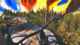
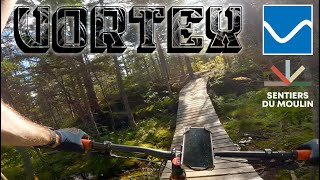
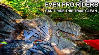
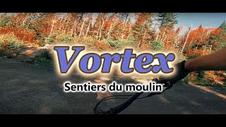
La Vortex, un sentier xc à profil descendant parfaitement intégrée à la géologie du secteur Maelstrom. La première portion très fluide est un enchaînement de roche mère, terre brune et passerelles alors que le 2e tronçon vous donnera de bon feeling avec des sections rocheuses plus exposées et une belle descente à la Slab City.

Gestion de projet : Éric Gagnon et Nicolas Sauvé
Design : Nicolas Sauvé et Patrice Dorion (Velosolutions)
Aménagement : Velosolutions Canada (Patrice Dorion)

Trail Supporters

  • Sponsor
Local Trail Association
Traditionally Indigenous Territory

Recent Activity on Trail

Past Week
  • 10 rides
  • 20.5 km average
6 Months
  • 65 rides
  • 18.8 km avg distance
All
  • 993 rides
  • Last: Jul 2, 2026
c1c2c3c4
January
February
March
April
May
June
July
August
September
October
November
December
Status:
on May 23, 2026
Ideal
Avg: 4.42 (20 votes)
Your vote: 0

view (6,874)
close
3D
Trail Conditions
  • Unknown
  • Snow Groomed
  • Snow Packed
  • Snow Covered
  • Snow Cover Partial
  • Freeze/thaw Cycle
  • Icy
  • Prevalent Mud
  • Wet
  • Variable
  • Ideal
  • Dry
  • Very Dry
Trail Flow (Ridden Direction)
Trailforks scans users ridelogs to determine the most popular direction each trail is ridden. A good flowing trail network will have most trails flowing in a single direction according to their intension.
The colour categories are based on what percentage of riders are riding a trail in its intended direction.
  • > 96%
  • > 90%
  • > 80%
  • > 70%
  • > 50%
  • < 50%
  • bi-directional trail
  • no data
Trail Last Ridden
Trailforks scans ridelogs to determine the last time a trail was ridden.
  • < 2 days
  • < 1 week
  • < 2 weeks
  • < 1 month
  • < 6 months
  • > 6 months
Trail Ridden Direction
The intended direction a trail should be ridden.
  • Downhill Only
  • Downhill Primary
  • Both Directions
  • Uphill Primary
  • Uphill Only
  • One Direction
Contribute Details
Colors indicate trail is missing specified detail.
  • Description
  • Photos
  • Description & Photos
  • Videos
Trail Popularity ?
Trailforks scans ridelogs to determine which trails are ridden the most in the last 9 months. Trails are compared with nearby trails in the same city region with a possible 25 colour shades. Think of this as a heatmap, more rides = more kinetic energy = warmer colors.
  • most popular
  • popular
  • less popular
  • not popular
ATV/ORV/OHV Filter
Max Vehicle Width
inches
US Cell Coverage
Legend
cell carrier legend

Radar Time
Activity Recordings
Trailforks uses anonymized public activity data. ?
Activity Recordings
Trailforks uses anonymized public activity data. ?
Personal Heatmap
Activity Types
all / none
Options
2
Date range month
Winter Trails
Warning A routing network for winter maps does not exist. Selecting trails using the winter trails layer has been disabled.
Missing Trails
Most Popular
Least Popular
Trails are colored based on popularity. The more popular a trail is, the more red. Less popular trails trend towards green.
Jump Magnitude Heatmap
Heatmap of where riders jump on trails. Zoom in to see individual jumps, click circles to view jump details.
BC Backroad Status

Service Road Atlas is a free to use, community-driven service for viewing and creating reports on the numerous back-country service roads around B.C. and Alberta.

map legend
Slope Aspect
Direction the slope faces
Flat N NE E SE S SW W NW
Trails Deemphasized
Trails are shown in grey.
disable
Only show trails with no bike usage.
Enable
Suggested Layers
Based on selected activity type

    Save the current map location and zoom level as your default home location whenever this page is loaded.

    Save
        Directions to vortex-217650 trailhead (46.978500, -71.251460)

        Photos

        4 more »
        225 |
        Jan 6, 2022 @ 7:45am
        Jan 6, 2022
        149 |
        Oct 6, 2021 @ 6:20pm
        Oct 6, 2021
        263 |
        Jul 20, 2020 @ 10:59am
        Jul 20, 2020
        293 |
        Jul 3, 2020 @ 7:20pm
        Jul 3, 2020

        Videos

        8 more »
        youtuber Vortex, Klondike etc. - Great XC loop at...
        32:57 | 452 | Jun 2, 2022 , Lac Beauport
        youtuber R. Rides Vortex | Sentiers Du Moulin
        5:29 | 314 | Oct 6, 2021 , Lac Beauport
        youtuber Riding The Hardest Tech Trail in The Northeast...
        17:51 | 138 | Jan 27, 2025 , Lac Beauport
        Vortex - Sentiers du Moulin
        5:39 | 134 | Oct 1, 2024 , Lac Beauport

        Routes with this trail

        6 miles 932 ft 5 Loop
        An exploration of the zone through the intermediate trails. Outstanding XC loop with great views... Do it...
        18 miles 2,959 ft 21
        Club mathieu performance 30km entrainement
        16 miles 2,956 ft 19 Loop
        Presque toutes les sentiers du secteur Maelstrom

        Reviews / Comments

        No reviews yet, be the first to write a review or ask a question.
        Use trail reports to comment on trail conditions.


        We hope you've been enjoying Trailforks!

        Create a FREE account to view trail comments and much more.

        • By Nicsauve & contributors
        • #217650 - 2,862 views

        Frequently Asked Questions About Vortex

        Where is Vortex located?
        Vortex is located in Sentiers du Moulin, Lac Beauport, Quebec, Canada. It is part of the Sentiers du Moulin trail network. The trailhead is located at coordinates 46.9785, -71.25146.
        How hard is Vortex?
        Vortex is rated as Blue difficulty. The physical rating is Moderate. The average grade is 4.2%. The climb difficulty is rated Blue.
        What is the elevation gain for Vortex?
        Vortex has 22 ft of elevation gain. The trail has 211 ft of elevation descent. The elevation ranges from 1,659 ft to 1,854 ft.
        Is Vortex a point to point trail?
        Yes, Vortex is a point to point trail. The direction is Downhill Only. The trail type is singletrack.

        Hit the Trail

        Open in App

        Get this trail on your phone instantly.
        open trail in app

        Download Trail

        Save to wishlist, Garmin & download.
        save the trail

        Find Related Routes

        Find routes and users activities that include this trail.
        find routes for this trail

        You must enter a description before submitting.