4.3 miles
Distance
150 ft
Climb
-1,207 ft
Descent
00:55:16
Avg time
Supporters, Builders, Maintainers & Land Managers of Sawmill Trail
USFSLand Manager
Sawmill Details
-
Activities
- Mountain Bike
- Hike
- Trail Running
-
Riding AreaWest Eagle
Eagle, Colorado -
Difficulty Rating
-
Voted DifficultyDouble Black Diamond (1 vote)
-
Hiking SAC ScaleT1 Hiking
-
Trail TypeSingletrack
-
Bike TypeDH, AM, XC
-
DirectionDownhill PrimaryPopular direction shown
-
Climb DifficultyBlack Diamond
-
Physical RatingHard
-
Dogs AllowedYes
-
eBike Allowed
-
Global Ranking#39774 in Mountain Biking
-
Local Popularity30 in Mountain Biking [+]
- 5 in Trail Running
- 5 in Hiking
-
Land OwnerUSFS
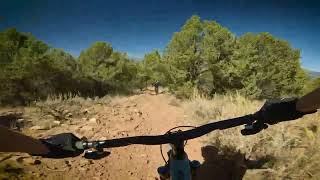
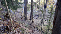
Amazing views and amazing finish. Starts off with a steep climb, followed by a few steep ups and fun downs. At about 1.7 miles in the sustained downhill finish starts in a big open meadow before tightening up into the creek drainage. Once in the drainage, the trail becomes super rocky, technical, and fun
Local Trail Association
-
Please consider joining or donating to the local trail association to supportdonate to earn trail karma!
trail development & maintenance.
Traditionally Indigenous Territory
More Stats for Sawmill multi-use trail trail
-
Altitude change-1,057 ft
-
Altitude min9,609 ft
-
Altitude max10,757 ft
-
Altitude start10,666 ft
-
Altitude end9,610 ft
-
Grade-4.7%
-
Grade max-22.1%
-
Grade min9.7%
-
Distance climb2,303 ft
-
Distance down4 miles
-
Distance flat1,063 ft
-
Avg time00:55:16
-
Avg reverse time01:31:47
- view trail stats
close
3D
Trail Conditions
- Unknown
- Snow Groomed
- Snow Packed
- Snow Covered
- Snow Cover Partial
- Freeze/thaw Cycle
- Icy
- Prevalent Mud
- Wet
- Variable
- Ideal
- Dry
- Very Dry
Trail Flow (Ridden Direction)
Trailforks scans users ridelogs to determine the most popular direction each trail is ridden. A good flowing trail network will have most trails flowing in a single direction according to their intension.
The colour categories are based on what percentage of riders are riding a trail in its intended direction.
- > 96%
- > 90%
- > 80%
- > 70%
- > 50%
- < 50%
- bi-directional trail
- no data
Trail Last Ridden
Trailforks scans ridelogs to determine the last time a trail was ridden.
- < 2 days
- < 1 week
- < 2 weeks
- < 1 month
- < 6 months
- > 6 months
Trail Ridden Direction
The intended direction a trail should be ridden.
- Downhill Only
- Downhill Primary
- Both Directions
- Uphill Primary
- Uphill Only
- One Direction
Contribute Details
Colors indicate trail is missing specified detail.
- Description
- Photos
- Description & Photos
- Videos
Trail Popularity ?
Trailforks scans ridelogs to determine which trails are ridden the most in the last 9 months.
Trails are compared with nearby trails in the same city region with a possible 25 colour shades.
Think of this as a heatmap, more rides = more kinetic energy = warmer colors.
- most popular
- popular
- less popular
- not popular
ATV/ORV/OHV Filter
Max Vehicle Width
inches
US Cell Coverage
Legend
Radar Time
x
Activity Recordings
Trailforks users anonymized public ridelogs from the past 6 months.
- mountain biking recent
- mountain biking (>6 month)
- hiking (1 year)
- moto (1 year)
Activity Recordings
Trailforks users anonymized public skilogs from the past 12 months.
- Downhill Ski
- Backcountry Ski
- Nordic Ski
- Snowmobile
Winter Trails
Warning
A routing network for winter maps does not exist. Selecting trails using the winter trails layer has been disabled.
x
Missing Trails
Most Popular
Least Popular
Trails are colored based on popularity. The more popular a trail is, the more red. Less popular trails trend towards green.
Jump Magnitude Heatmap
Heatmap of where riders jump on trails. Zoom in to see individual jumps, click circles to view jump details.
Trails Deemphasized
Trails are shown in grey.
Only show trails with NO bikes.
Save the current map location and zoom level as your default home location whenever this page is loaded.
Save
Directions to sawmill trailhead
(39.514510, -106.819460)
update trails status or condition
Sawmill Trail Reports
view all reports »
Recent Ridelog Activity on Trail
Past Week
- 0 rides
6 Months
- 0 rides
All
- 16 rides
- Last: Sep 8, 2024
Photos
more »
Routes with this trail
3 Reviews & Comments
We hope you've been enjoying Trailforks!
Create a FREE account to view trail comments and much more.
Nearby Trails
- Yates Gulch Trail 2 miles
- Lost Lake Trail #2224 5 miles
- Gypsum Creek To Hardscrabble 6 miles
- West Brush Creek 6 miles
- Brush Creek Road 6 miles
- By LalaT
HTC & contributors
- #106231 - 4,779 views
- follow/subscribe
- login to download gpx or kml files.
You must enter a description before submitting.