more stats
2,976 ft
Distance
-497 ft
Descent
00:04:28
Avg time
-497 ft
Altitude change
1,721 ft
Altitude min
2,218 ft
Altitude max
2,218 ft
Altitude start
1,722 ft
Altitude end
-16.7%
Grade
-69.2%
Grade max
1.9%
Grade min
157 ft
Distance climb
2,625 ft
Distance down
194 ft
Distance flat
00:04:28
Avg time

Secaù Details

  • Activities
    • Mountain Bike
    • E-Bike
    • Hike
    • Trail Running
  • Riding Area
  • AKA
    Variante Casiraghi
  • Difficulty Rating
  • Voted Difficulty
    Black (1 vote)
  • Local Popularity
    70 in Mountain Biking [+]
    • 80 in E-Biking
    • 5 in Trail Running
    • 90 in Hiking
  • Global Ranking
    #78621 in Mountain Biking [+]
    • #32008 in E-Biking
    • #132179 in Trail Running
    • #2921 in Hiking
  • Hiking SAC Scale
    T2 Mountain Hiking
  • Trail Type
    Singletrack
  • Bike Type
    AM, XC
  • Direction
    Downhill Only
    Popular Direction Shown
  • Physical Rating
    Hard
  • Dogs Allowed
    Yes
  • eBike Allowed
    Yes up to Class 1
  • TTFs on Trail
    Berm, Drop, Jump, Rock Face, Rock Garden, Roller Coaster, Other
  • Land Owner
    Lecco

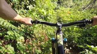
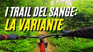
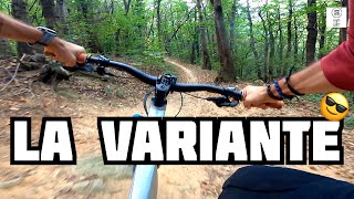
Secaù o meglio conosciuto come "il Variante" è un sentiero poco lavorato e molto naturale che inizia con un semplice e divertente toboga e prosegue con passaggi più tecnici su sasso fisso. Nella parte centrale, rimane leggermente esposto in alcuni punti al vallone sulla sua destra dove occorre prestare attenzione. La parte finale invece è caratterizzata da un rock garden che impegna nella scelta della linea corretta.

Access Info

Campsirago, Monte Crosaccia.

Disclaimer

Divertiti con responsabilità e ricorda che i sentieri non sono ad uso esclusivo delle biciclette; potresti trovare dei pedoni: rallenta, sorpassa a passo d'uomo e saluta (è sempre buona educazione) dopodiché, continua a goderti il sentiero.

Recent Activity on Trail

Past Week
  • 0 rides
  •  
6 Months
  • 4 rides
  • 21 miles avg distance
All
  • 54 rides
  • Last: Jun 14, 2026
c1c2c3c4
January
February
March
April
May
June
July
August
September
October
November
December
update trails status or condition

Secaù Trail Reports

statusdatedescription
Jun 16, 2026 @ 3:31pm (Europe/Rome)
Jun 16, 2026
Alberi caduti e vegetazione che chiude
Jun 14, 2026 @ 2:38pm (Europe/Vaduz)
Jun 14, 2026
rovi che quasi chiudono il passaggio. alberi caduti
Mar 6, 2026 @ 12:29am (Pacific/Midway)
Mar 6, 2026
Un po di foglie ma godibile
Nov 29, 2025 @ 9:35am (Europe/Rome)
Nov 29, 2025
reporter
Oct 13, 2025 @ 7:21pm (Europe/Rome)
Oct 13, 2025
reporter ATTENZIONE Una ventina di piante cadute ancora da tagliare.
more »
Status:
on Jun 16, 2026
Dry
Avg: 4.17 (5 votes)
Your vote: 0

view (488)
close
3D
Trail Conditions
  • Unknown
  • Snow Groomed
  • Snow Packed
  • Snow Covered
  • Snow Cover Partial
  • Freeze/thaw Cycle
  • Icy
  • Prevalent Mud
  • Wet
  • Variable
  • Ideal
  • Dry
  • Very Dry
Trail Flow (Ridden Direction)
Trailforks scans users ridelogs to determine the most popular direction each trail is ridden. A good flowing trail network will have most trails flowing in a single direction according to their intension.
The colour categories are based on what percentage of riders are riding a trail in its intended direction.
  • > 96%
  • > 90%
  • > 80%
  • > 70%
  • > 50%
  • < 50%
  • bi-directional trail
  • no data
Trail Last Ridden
Trailforks scans ridelogs to determine the last time a trail was ridden.
  • < 2 days
  • < 1 week
  • < 2 weeks
  • < 1 month
  • < 6 months
  • > 6 months
Trail Ridden Direction
The intended direction a trail should be ridden.
  • Downhill Only
  • Downhill Primary
  • Both Directions
  • Uphill Primary
  • Uphill Only
  • One Direction
Contribute Details
Colors indicate trail is missing specified detail.
  • Description
  • Photos
  • Description & Photos
  • Videos
Trail Popularity ?
Trailforks scans ridelogs to determine which trails are ridden the most in the last 9 months. Trails are compared with nearby trails in the same city region with a possible 25 colour shades. Think of this as a heatmap, more rides = more kinetic energy = warmer colors.
  • most popular
  • popular
  • less popular
  • not popular
ATV/ORV/OHV Filter
Max Vehicle Width
inches
US Cell Coverage
Legend
cell carrier legend

Radar Time
Activity Recordings
Trailforks uses anonymized public activity data. ?
Activity Recordings
Trailforks uses anonymized public activity data. ?
Personal Heatmap
Activity Types
all / none
Options
2
Date range month
Winter Trails
Warning A routing network for winter maps does not exist. Selecting trails using the winter trails layer has been disabled.
Missing Trails
Most Popular
Least Popular
Trails are colored based on popularity. The more popular a trail is, the more red. Less popular trails trend towards green.
Jump Magnitude Heatmap
Heatmap of where riders jump on trails. Zoom in to see individual jumps, click circles to view jump details.
BC Backroad Status

Service Road Atlas is a free to use, community-driven service for viewing and creating reports on the numerous back-country service roads around B.C. and Alberta.

map legend
Slope Aspect
Direction the slope faces
Flat N NE E SE S SW W NW
Trails Deemphasized
Trails are shown in grey.
disable
Only show trails with no bike usage.
Enable
Suggested Layers
Based on selected activity type

    Save the current map location and zoom level as your default home location whenever this page is loaded.

    Save
        Directions to secau trailhead (45.748530, 9.406130)

        Photos

        13 more »
        36 |
        Jun 29, 2025 @ 3:38am
        Jun 29, 2025
        29 |
        Jun 29, 2025 @ 3:38am
        Jun 29, 2025
        33 |
        Jun 29, 2025 @ 3:38am
        Jun 29, 2025
        39 |
        Oct 20, 2023 @ 3:02am
        Oct 20, 2023

        Videos

        4 more »
        UN DISASTRO TOTALE
        26:49 | 51 | Jun 29, 2025 , Dolzago
        I Trail del San Genesio : LA VARIANTE
        4:19 | 119 | May 9, 2024 , Dolzago
        La Variante del Sange | Hardtail
        4:40 | 80 | Nov 28, 2023 , Dolzago
        ONE SHOT! La Variante
        6:21 | 83 | Oct 19, 2023 , Dolzago

        1 Review & Comments


        We hope you've been enjoying Trailforks!

        Create a FREE account to view trail comments and much more.

        • By turbolinceTF Pro & contributors
        • #184215 - 1,711 views

        Frequently Asked Questions About Secaù

        Where is Secaù located?
        Secaù is located in Monte di Brianza, Dolzago, Italy. It is part of the Monte di Brianza trail network. The trailhead is located at coordinates 45.74853, 9.40613.
        How hard is Secaù?
        Secaù is rated as Red difficulty. The physical rating is Hard. The average grade is 16.7%.
        What is the elevation gain for Secaù?
        The trail has 497 ft of elevation descent. The elevation ranges from 1,721 ft to 2,218 ft.
        Is Secaù a point to point trail?
        Yes, Secaù is a point to point trail. The direction is Downhill Only. The trail type is singletrack.

        Hit the Trail

        Open in App

        Get this trail on your phone instantly.
        open trail in app

        Download Trail

        Save to wishlist, Garmin & download.
        save the trail

        Find Related Routes

        Find routes and users activities that include this trail.
        find routes for this trail

        You must enter a description before submitting.