more stats
3,101 ft
Distance
459 ft
Climb
00:10:57
Avg time
459 ft
Altitude change
7,261 ft
Altitude min
7,719 ft
Altitude max
7,261 ft
Altitude start
7,719 ft
Altitude end
14.787%
Grade
-0.413%
Grade max
96.246%
Grade min
3,070 ft
Distance climb
31 ft
Distance flat
00:10:57
Avg time

Second Left Fork Details

  • Activities
    • Mountain Bike
    • Hike
    • Trail Running
  • Riding Area
    Provo Canyon
    Provo, Utah
  • Difficulty Rating
  • Local Popularity
    55 in Mountain Biking [+]
    • 70 in Trail Running
    • 35 in Hiking
  • Global Ranking
    #103509 in Mountain Biking [+]
    • #86715 in Trail Running
    • #112825 in Hiking
  • Trail Type
    Singletrack
  • Direction
    Both Directions
  • Dogs Allowed
    Yes

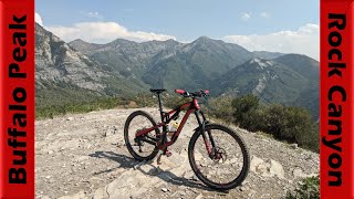
A bit grown over at the bottom, but offers some good fast flow down. If you are slugged it up through the rocks of Rock Canyon, this is probably a welcome climb.

This trail is unsanctioned.

Trail Supporters

  • USFS
    Land Manager
Traditionally Indigenous Territory

Recent Activity on Trail

Past Week
  • 0 rides
  •  
6 Months
  • 1 rides
  • 13 miles avg distance
All
  • 27 rides
  • Last: Jun 30, 2026
c1c2c3c4
January
February
March
April
May
June
July
August
September
October
November
December
update trails status or condition

Second Left Fork Trail Reports

statusdatedescription
Sep 30, 2022 @ 1:57pm
Sep 30, 2022
Grass is over growing the trail in sections. It is a unforgiving single track with hidden rocks and stumps. So having the grass make it so you...
Jun 30, 2022 @ 5:40am
Jun 30, 2022
perfect dirt right now
Jun 4, 2022 @ 9:17am
Jun 4, 2022
May 15, 2022 @ 7:52pm
May 15, 2022
Dry except for big puddles at every erosion control cut (of which there are several). Probably needs another week.
Sep 2, 2021 @ 5:18pm
Sep 2, 2021
Minor fallen log issue - might have trouble if you have a really low BB
more »
Status:
on Sep 30, 2022
Dry
Avg: 4.1 (3 votes)
Your vote: 0

view (570)
close
3D
Trail Conditions
  • Unknown
  • Snow Groomed
  • Snow Packed
  • Snow Covered
  • Snow Cover Partial
  • Freeze/thaw Cycle
  • Icy
  • Prevalent Mud
  • Wet
  • Variable
  • Ideal
  • Dry
  • Very Dry
Trail Flow (Ridden Direction)
Trailforks scans users ridelogs to determine the most popular direction each trail is ridden. A good flowing trail network will have most trails flowing in a single direction according to their intension.
The colour categories are based on what percentage of riders are riding a trail in its intended direction.
  • > 96%
  • > 90%
  • > 80%
  • > 70%
  • > 50%
  • < 50%
  • bi-directional trail
  • no data
Trail Last Ridden
Trailforks scans ridelogs to determine the last time a trail was ridden.
  • < 2 days
  • < 1 week
  • < 2 weeks
  • < 1 month
  • < 6 months
  • > 6 months
Trail Ridden Direction
The intended direction a trail should be ridden.
  • Downhill Only
  • Downhill Primary
  • Both Directions
  • Uphill Primary
  • Uphill Only
  • One Direction
Contribute Details
Colors indicate trail is missing specified detail.
  • Description
  • Photos
  • Description & Photos
  • Videos
Trail Popularity ?
Trailforks scans ridelogs to determine which trails are ridden the most in the last 9 months. Trails are compared with nearby trails in the same city region with a possible 25 colour shades. Think of this as a heatmap, more rides = more kinetic energy = warmer colors.
  • most popular
  • popular
  • less popular
  • not popular
ATV/ORV/OHV Filter
Max Vehicle Width
inches
US Cell Coverage
Legend
cell carrier legend

Radar Time
Activity Recordings
Trailforks uses anonymized public activity data. ?
Activity Recordings
Trailforks uses anonymized public activity data. ?
Personal Heatmap
Activity Types
all / none
Options
2
Date range month
Winter Trails
Warning A routing network for winter maps does not exist. Selecting trails using the winter trails layer has been disabled.
Missing Trails
Most Popular
Least Popular
Trails are colored based on popularity. The more popular a trail is, the more red. Less popular trails trend towards green.
Jump Magnitude Heatmap
Heatmap of where riders jump on trails. Zoom in to see individual jumps, click circles to view jump details.
BC Backroad Status

Service Road Atlas is a free to use, community-driven service for viewing and creating reports on the numerous back-country service roads around B.C. and Alberta.

map legend
Slope Aspect
Direction the slope faces
Flat N NE E SE S SW W NW
Trails Deemphasized
Trails are shown in grey.
disable
Only show trails with no bike usage.
Enable
Suggested Layers
Based on selected activity type

    Save the current map location and zoom level as your default home location whenever this page is loaded.

    Save
        Directions to second-left-fork trailhead (40.278120, -111.596580)

        Photos

        2 more »
        203 |
        Dec 14, 2014 @ 9:13pm
        Dec 14, 2014
        69 |
        Jun 23, 2020 @ 12:02pm
        Jun 23, 2020

        Videos

        1 more »
        Buffalo Peak & Rock Canyon Descent!
        18:39 | 178 | Sep 9, 2021 , Provo

        Routes with this trail

        17 miles 3,849 ft 22
        Not sure on all the climbing
        Squaw Peak 50 Archived
        50 miles 9,794 ft 12 Loop Race
        Squaw Peak 50 course Starts at Vivian Park in Provo Canyon, up to Hope Campground, along road to Hobble...

        1 Review & Comments


        We hope you've been enjoying Trailforks!

        Create a FREE account to view trail comments and much more.

        • #9537 - 1,230 views

        Frequently Asked Questions About Second Left Fork

        Where is Second Left Fork located?
        Second Left Fork is located in Provo Canyon, Provo, Utah, United States. It is part of the Provo Canyon trail network. The trailhead is located at coordinates 40.27812, -111.59658.
        How hard is Second Left Fork?
        Second Left Fork is rated as Black Diamond difficulty. The average grade is 14.787%.
        What is the elevation gain for Second Left Fork?
        Second Left Fork has 459 ft of elevation gain. The elevation ranges from 7,261 ft to 7,719 ft.
        Is Second Left Fork a point to point trail?
        Second Left Fork is not a point to point trail. The direction is Both Directions. The trail type is singletrack.

        Hit the Trail

        Open in App

        Get this trail on your phone instantly.
        open trail in app

        Download Trail

        Save to wishlist, Garmin & download.
        save the trail

        Find Related Routes

        Find routes and users activities that include this trail.
        find routes for this trail

        You must enter a description before submitting.