

more stats
1.2 miles
Distance
60 ft
Climb
-61 ft
Descent
00:08:13
Avg time
1 ft
Altitude change
917 ft
Altitude min
949 ft
Altitude max
919 ft
Altitude start
919 ft
Altitude end
-9.4%
Grade max
9.2%
Grade min
1,631 ft
Distance climb
1,732 ft
Distance down
2,776 ft
Distance flat
00:08:13
Avg time

Section 12 - Buckstown Details

  • Activities
    • Mountain Bike
    • Gravel Bike
    • Winter Fat Bike
    • Hike
    • Trail Running
    • Snowshoe
    • Nordic Ski
  • Riding Area
  • Difficulty Rating
  • Voted Difficulty
    Blue (2 votes)
  • Local Popularity
    95 in Mountain Biking [+]
    • 100 in Trail Running
    • 100 in Hiking
    • 90 in Snowshoeing
    • 5 in Nordic Skiing
    • 100 in Winter Fat Biking
    • 90 in Gravel Biking
  • Global Ranking
    #417 in Mountain Biking [+]
    • #85836 in Trail Running
    • #93839 in Hiking
    • #2128 in Snowshoeing
    • #1955 in Winter Fat Biking
    • #8338 in Gravel Biking
  • Provincial Ranking
    #9 in Mountain Biking · Ontario [+]
    • #2,038 in Trail Running
    • #3,068 in Hiking
    • #501 in Snowshoeing
    • #442 in Winter Fat Biking
    • #430 in Gravel Biking
  • Hiking SAC Scale
    T1 Hiking
  • Trail Type
    Singletrack
  • Snow Grooming
    Backcountry
  • Bike Type
    AM, XC, Fat, Gravel
  • Direction
    Both Directions[+]
    Popular Direction Shown
    • Both Directions for Winter Fat Biking
    • Both Directions for Gravel Biking
  • Dogs Allowed
    Yes
  • eBike Allowed
  • TTFs on Trail
    Berm, Jump
  • Land Owner
    Toronto Region Conservation Authority

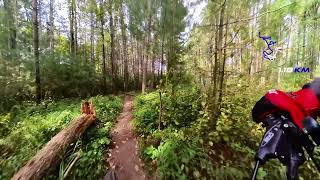
Mix of climbs, fast downhills, tight singletrack through dense and open pines and firs, amazing loose berms, and a few grassy areas.

This trail is unsanctioned.

Tags
BermsJumps

Recent Activity on Trail

Past Week
  • 17 rides
  • 20.0 km average
6 Months
  • 544 rides
  • 20.9 km avg distance
All
  • 2,410 rides
  • Last: Nov 10, 2026
c1c2c3c4
January
February
March
April
May
June
July
August
September
October
November
December
Status:
on Nov 7, 2026
Variable
Avg: 4.43 (10 votes)
Your vote: 0

view (6,967)
close
      Directions to section-12-buckstown trailhead (43.959140, -79.855360)

      Photos

      8 more »
      mtb
      22 |
      May 26, 2026 @ 6:23am
      May 26, 2026
      mtb
      46 |
      Feb 26, 2026 @ 6:23pm
      Feb 26, 2026
      mtb
      108 |
      Jan 1, 2024 @ 7:42am
      Jan 1, 2024
      mtb
      56 |
      Sep 14, 2023 @ 4:19pm
      Sep 14, 2023

      Videos

      1 more »
      Palgrave - Sec 12 Buckstown -20240908
      mtb
      7:46 | 152 | Sep 10, 2024 , Caledon

      Routes with this trail

      more »
      ★ 5.0 • 11 miles • 712 ft • 13 •
      The Complete Essential Palgrave CALEDON Impossible Route, With The Best Trails. Counter Clockwise 2022....
      11 miles • 716 ft • 10 • Loop •
      A mostly flowy loop with some technical bits, starting from the parking on Duffy's Lane.
      35 miles • 3,191 ft • 40 •
      A really fun link up of the three trails systems, Albion Hills, Palgrave, and Glen Haffy. It has a bit of...
      4.7 ★★★★★
      10 Ratings
      5 ★ 90%
      4 ★
      3 ★
      2 ★ 10%
      1 ★

      3 Reviews & Comments

      extremumadventura extremumadventura
      There are several one two drops in this section now and you can actually jump the drop in reverse
      sidq
      Great work building this trail. Lots of fun and flow. My new fav at Plagrrave
      347volt
      There is no drop, jump, or log ride ad the description says. But this trail is quite fun and flows well! Great job!

      We hope you've been enjoying Trailforks!

      Create a FREE account to view all trail reviews and much more.

      • #550723 - 1,737 views

      Frequently Asked Questions

      ▼ Where is Section 12 - Buckstown located?
      Section 12 - Buckstown is located in Palgrave Forest and Wildlife Area, Caledon, Ontario, Canada. It is part of the Palgrave Forest and Wildlife Area trail network. The trailhead is located at coordinates 43.95914, -79.85536.
      ▼ How hard is Section 12 - Buckstown?
      Section 12 - Buckstown is rated as Blue difficulty.
      ▼ What is the elevation gain for Section 12 - Buckstown?
      Section 12 - Buckstown has 60 ft of elevation gain. The trail has 61 ft of elevation descent. The elevation ranges from 917 ft to 949 ft.
      ▼ Is Section 12 - Buckstown a point to point trail?
      Section 12 - Buckstown is not a point to point trail. The direction is Both Directions. The trail type is singletrack.
      ▼ How long is Section 12 - Buckstown?
      Section 12 - Buckstown is 1.2 miles long. The trail type is singletrack.
      ▼ Are dogs allowed on Section 12 - Buckstown?
      Yes, dogs are allowed on Section 12 - Buckstown. Please keep dogs on a leash where required and clean up after them.
      ▼ When is the best time of year to ride Section 12 - Buckstown?
      Based on activity log data, the most popular months to ride Section 12 - Buckstown are:
      • September (248 activities)
      • July (228 activities)
      • October (221 activities)
      Check the reports page for current trail conditions.
      ▼ How do I access Section 12 - Buckstown? Where is the closest parking trailhead?
      The closest parking and trailhead locations to Section 12 - Buckstown are: View all parking locations in the area.
      ▼ How long does it take to ride Section 12 - Buckstown?
      Based on recorded activities, it takes an average of 8 minutes to ride Section 12 - Buckstown. The trail is 1.2 miles long. Actual times will vary based on fitness level, conditions, and pace. View recent activity logs for more details.
      ▼ How busy is Section 12 - Buckstown?
      Section 12 - Buckstown is a very popular trail. There have been 6,339 recorded activities on this trail. The trail has received 6,967 check-ins. View recent activity on this trail.

      Hit the Trail

      Open in App

      Get this trail on your phone instantly.

      open trail in app

      Download Trail

      Save to wishlist, Garmin & download.
      save the trail

      Find Related Routes

      Find routes and users activities that include this trail.
      find routes for this trail

      You must enter a description before submitting.

