more stats
4,281 ft
Distance
33 ft
Climb
-17 ft
Descent
00:04:53
Avg time
14 ft
Altitude change
933 ft
Altitude min
968 ft
Altitude max
951 ft
Altitude start
965 ft
Altitude end
0.3%
Grade
-4.4%
Grade max
11.8%
Grade min
968 ft
Distance climb
1,181 ft
Distance down
2,133 ft
Distance flat
00:04:53
Avg time

Section 7 Details

  • Activities
    • Mountain Bike
    • Hike
    • Trail Running
    • Snowshoe
    • Nordic Ski
  • Riding Area
    Palgrave Conservation Area
    Caledon, Ontario
  • Difficulty Rating
  • Voted Difficulty
    Blue (1 vote)
  • Local Popularity
    80 in Mountain Biking [+]
    • 85 in Trail Running
    • 85 in Hiking
    • 5 in Snowshoeing
    • 5 in Nordic Skiing
  • Global Ranking
    #73513 in Mountain Biking [+]
    • #54365 in Trail Running
    • #65111 in Hiking
    • #3163 in Snowshoeing
  • Trail Type
    Singletrack
  • Snow Grooming
    Backcountry
  • Bike Type
    XC
  • Direction
    Both Directions
    Popular Direction Shown
  • Climb Difficulty
    Blue
  • Physical Rating
    Moderate
  • Season
    All
  • Dogs Allowed
    Yes
  • eBike Allowed
  • Land Owner
    Toronto Region Conservation Authority

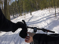
This section offers mostly fast, flowing doubletrack, perfect for picking increasing your average speed. Be prepared for a tough, sustained climb around the halfway point. The grand finale is a thrilling downhill, albeit a bit rutted, that delivers you directly to the entrance of the Last Resort.

Recent Activity on Trail

Past Week
  • 2 rides
  • 11 miles average
6 Months
  • 26 rides
  • 16 miles avg distance
All
  • 899 rides
  • Last: Jun 4, 2026
c1c2c3c4
January
February
March
April
May
June
July
August
September
October
November
December
Status:
on May 30, 2026
Dry
Avg: 3.76 (3 votes)
Your vote: 0

view (4,045)
close
3D
Trail Conditions
  • Unknown
  • Snow Groomed
  • Snow Packed
  • Snow Covered
  • Snow Cover Partial
  • Freeze/thaw Cycle
  • Icy
  • Prevalent Mud
  • Wet
  • Variable
  • Ideal
  • Dry
  • Very Dry
Trail Flow (Ridden Direction)
Trailforks scans users ridelogs to determine the most popular direction each trail is ridden. A good flowing trail network will have most trails flowing in a single direction according to their intension.
The colour categories are based on what percentage of riders are riding a trail in its intended direction.
  • > 96%
  • > 90%
  • > 80%
  • > 70%
  • > 50%
  • < 50%
  • bi-directional trail
  • no data
Trail Last Ridden
Trailforks scans ridelogs to determine the last time a trail was ridden.
  • < 2 days
  • < 1 week
  • < 2 weeks
  • < 1 month
  • < 6 months
  • > 6 months
Trail Ridden Direction
The intended direction a trail should be ridden.
  • Downhill Only
  • Downhill Primary
  • Both Directions
  • Uphill Primary
  • Uphill Only
  • One Direction
Contribute Details
Colors indicate trail is missing specified detail.
  • Description
  • Photos
  • Description & Photos
  • Videos
Trail Popularity ?
Trailforks scans ridelogs to determine which trails are ridden the most in the last 9 months. Trails are compared with nearby trails in the same city region with a possible 25 colour shades. Think of this as a heatmap, more rides = more kinetic energy = warmer colors.
  • most popular
  • popular
  • less popular
  • not popular
ATV/ORV/OHV Filter
Max Vehicle Width
inches
US Cell Coverage
Legend
cell carrier legend

Radar Time
Activity Recordings
Trailforks uses anonymized public activity data. ?
Activity Recordings
Trailforks uses anonymized public activity data. ?
Personal Heatmap
Activity Types
all / none
Options
2
Date range month
Winter Trails
Warning A routing network for winter maps does not exist. Selecting trails using the winter trails layer has been disabled.
Missing Trails
Most Popular
Least Popular
Trails are colored based on popularity. The more popular a trail is, the more red. Less popular trails trend towards green.
Jump Magnitude Heatmap
Heatmap of where riders jump on trails. Zoom in to see individual jumps, click circles to view jump details.
BC Backroad Status

Service Road Atlas is a free to use, community-driven service for viewing and creating reports on the numerous back-country service roads around B.C. and Alberta.

map legend
Slope Aspect
Direction the slope faces
Flat N NE E SE S SW W NW
Trails Deemphasized
Trails are shown in grey.
disable
Only show trails with no bike usage.
Enable
Suggested Layers
Based on selected activity type

    Save the current map location and zoom level as your default home location whenever this page is loaded.

    Save
        Directions to section-7 trailhead (43.956180, -79.861710)

        Photos

        No photos have been added for Section 7 yet, add a photo.

        Videos

        1 more »
        Palgrave Snow Biking
        0:48 | 44 | Jan 10, 2021 , Caledon

        Routes with this trail

        11 miles 800 ft 14
        Palgrave Good workout for your legs and lungs
        9 miles 487 ft 19
        Wanted to create a circuit with more descents. :)

        Reviews / Comments

        No reviews yet, be the first to write a review or ask a question.
        Use trail reports to comment on trail conditions.


        We hope you've been enjoying Trailforks!

        Create a FREE account to view trail comments and much more.

        • By hipposauceTF Pro & contributors
        • #20528 - 1,726 views

        Frequently Asked Questions About Section 7

        Where is Section 7 located?
        Section 7 is located in Palgrave Conservation Area, Caledon, Ontario, Canada. It is part of the Palgrave Conservation Area trail network. The trailhead is located at coordinates 43.95618, -79.86171.
        How hard is Section 7?
        Section 7 is rated as Green difficulty. The physical rating is Moderate. The average grade is 0.3%. The climb difficulty is rated Blue.
        What is the elevation gain for Section 7?
        Section 7 has 33 ft of elevation gain. The trail has 17 ft of elevation descent. The elevation ranges from 933 ft to 968 ft.
        Is Section 7 a point to point trail?
        Section 7 is not a point to point trail. The direction is Both Directions. The trail type is singletrack.

        Hit the Trail

        Open in App

        Get this trail on your phone instantly.
        open trail in app

        Download Trail

        Save to wishlist, Garmin & download.
        save the trail

        Find Related Routes

        Find routes and users activities that include this trail.
        find routes for this trail

        You must enter a description before submitting.