more stats
4,803 ft
Distance
5 ft
Climb
-1,005 ft
Descent
2,074 ft
High Point
-1,010 ft
Altitude change
1,064 ft
Altitude min
2,074 ft
Altitude start
1,063 ft
Altitude end
-21%
Grade
-50.4%
Grade max
12.7%
Grade min
154 ft
Distance climb
4,265 ft
Distance down
384 ft
Distance flat

Sendtaur Details

  • Activities
    • Mountain Bike
    • Hike
    • Trail Running
  • Riding Area
    The Zoo
    Port Angeles, Washington
  • Difficulty Rating
  • Local Popularity
    90 in Mountain Biking [+]
    • 5 in Trail Running
    • 5 in Hiking
  • Global Ranking
    #186977 in Mountain Biking [+]
    • #326572 in Trail Running
    • #336487 in Hiking
  • Hiking SAC Scale
    T1 Hiking
  • Trail Type
    Singletrack
  • Bike Type
    DH, AM
  • Direction
    Downhill Only[+]
    Popular Direction Shown
    • Downhill Only for Trail Running
    • Downhill Only for Hiking
  • Trail Visibility
    Always easy to follow
  • Dogs Allowed
    Yes
  • eBike Allowed
  • TTFs on Trail
    Berm, Drop, Rock Face, Rock Garden
  • Land Owner

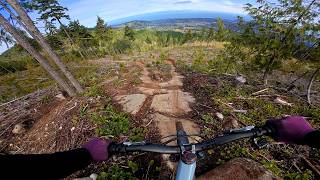
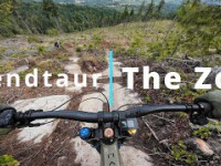
Slabs and rock features mixed with berms and flow. Sendtaur starts in the trees with moderate difficulty slab feature. If you're able to ride this first feature you'll soon be having a good time. If you're not comfortable with this first feature, you're going to be walking a lot on this one. There are multiple line options on most of the slabs, be sure to stop and take a look on your first lap. Sendtaur ends with a mandatory 800ft climb to get back up to any of the other trails. There is no outlet to Dan Kelly or Olympic Discovery Trail. This trail was made possible by donations and support from Top Left Trails Co-Op. Trail design by Josh Carruthers and Zach Wheeler.

Local Trail Association
Traditionally Indigenous Territory

Recent Activity on Trail

Past Week
  • 0 rides
  •  
6 Months
  • 53 rides
  • 14 miles avg distance
All
  • 84 rides
  • Last: Jun 20, 2026
c1c2c3c4
January
February
March
April
May
June
July
August
September
October
November
December
update trails status or condition

Sendtaur Trail Reports

statusdatedescription
May 21, 2026 @ 2:36pm (America/Los_Angeles)
May 21, 2026
So good
Jul 7, 2025 @ 4:09pm
Jul 7, 2025
reporter
Jul 7, 2025 @ 4:06pm
Jul 7, 2025
reporter
Brushed and raked lower section below the road.
more »
Status:
on May 21, 2026
Ideal
Avg: 5 (3 votes)
Your vote: 0

view (191)
close
3D
Trail Conditions
  • Unknown
  • Snow Groomed
  • Snow Packed
  • Snow Covered
  • Snow Cover Partial
  • Freeze/thaw Cycle
  • Icy
  • Prevalent Mud
  • Wet
  • Variable
  • Ideal
  • Dry
  • Very Dry
Trail Flow (Ridden Direction)
Trailforks scans users ridelogs to determine the most popular direction each trail is ridden. A good flowing trail network will have most trails flowing in a single direction according to their intension.
The colour categories are based on what percentage of riders are riding a trail in its intended direction.
  • > 96%
  • > 90%
  • > 80%
  • > 70%
  • > 50%
  • < 50%
  • bi-directional trail
  • no data
Trail Last Ridden
Trailforks scans ridelogs to determine the last time a trail was ridden.
  • < 2 days
  • < 1 week
  • < 2 weeks
  • < 1 month
  • < 6 months
  • > 6 months
Trail Ridden Direction
The intended direction a trail should be ridden.
  • Downhill Only
  • Downhill Primary
  • Both Directions
  • Uphill Primary
  • Uphill Only
  • One Direction
Contribute Details
Colors indicate trail is missing specified detail.
  • Description
  • Photos
  • Description & Photos
  • Videos
Trail Popularity ?
Trailforks scans ridelogs to determine which trails are ridden the most in the last 9 months. Trails are compared with nearby trails in the same city region with a possible 25 colour shades. Think of this as a heatmap, more rides = more kinetic energy = warmer colors.
  • most popular
  • popular
  • less popular
  • not popular
ATV/ORV/OHV Filter
Max Vehicle Width
inches
US Cell Coverage
Legend
cell carrier legend

Radar Time
Activity Recordings
Trailforks uses anonymized public activity data. ?
Activity Recordings
Trailforks uses anonymized public activity data. ?
Personal Heatmap
Activity Types
all / none
Options
2
Date range month
Winter Trails
Warning A routing network for winter maps does not exist. Selecting trails using the winter trails layer has been disabled.
Missing Trails
Most Popular
Least Popular
Trails are colored based on popularity. The more popular a trail is, the more red. Less popular trails trend towards green.
Jump Magnitude Heatmap
Heatmap of where riders jump on trails. Zoom in to see individual jumps, click circles to view jump details.
BC Backroad Status

Service Road Atlas is a free to use, community-driven service for viewing and creating reports on the numerous back-country service roads around B.C. and Alberta.

map legend
Slope Aspect
Direction the slope faces
Flat N NE E SE S SW W NW
Trails Deemphasized
Trails are shown in grey.
disable
Only show trails with no bike usage.
Enable
Suggested Layers
Based on selected activity type

    Save the current map location and zoom level as your default home location whenever this page is loaded.

    Save
        Directions to sendtaur trailhead (48.083570, -123.595360)

        Photos

        13 more »
        140 |
        Apr 26, 2025 @ 6:58am
        Apr 26, 2025
        130 |
        Apr 26, 2025 @ 6:57am
        Apr 26, 2025
        128 |
        Apr 26, 2025 @ 6:57am
        Apr 26, 2025
        152 |
        Apr 26, 2025 @ 6:57am
        Apr 26, 2025

        Videos

        2 more »
        youtuber Sendtaur || Squamish style trail in Washington!
        7:05 | 114 | Apr 13, 2026 , Port Angeles
        Sendtaur - The Zoo
        182 | Aug 17, 2025 , Port Angeles

        3 Reviews & Comments


        We hope you've been enjoying Trailforks!

        Create a FREE account to view trail comments and much more.

        • By erikhalfacreTF Pro TLTC & contributors
        • #839146 - 911 views

        Frequently Asked Questions About Sendtaur

        Where is Sendtaur located?
        Sendtaur is located in The Zoo, Port Angeles, Washington, United States. It is part of the The Zoo trail network. The trailhead is located at coordinates 48.08357, -123.59536.
        How hard is Sendtaur?
        Sendtaur is rated as Black Diamond difficulty. The average grade is 21%.
        What is the elevation gain for Sendtaur?
        Sendtaur has 5 ft of elevation gain. The trail has 1,005 ft of elevation descent. The elevation ranges from 1,064 ft to 2,074 ft.
        Is Sendtaur a point to point trail?
        Yes, Sendtaur is a point to point trail. The direction is Downhill Only. The trail type is singletrack.

        Hit the Trail

        Open in App

        Get this trail on your phone instantly.
        open trail in app

        Download Trail

        Save to wishlist, Garmin & download.
        save the trail

        Find Related Routes

        Find routes and users activities that include this trail.
        find routes for this trail

        You must enter a description before submitting.