more stats
2.8 miles
Distance
549 ft
Climb
-549 ft
Descent
00:32:21
Avg time
8,068 ft
Altitude min
8,294 ft
Altitude max
8,068 ft
Altitude start
8,068 ft
Altitude end
-27.502%
Grade max
23.909%
Grade min
1 mile
Distance climb
1 mile
Distance down
635 ft
Distance flat
00:32:21
Avg time

Shadow Pine Loop Details

  • Activities
    • Mountain Bike
    • E-Bike
    • Hike
    • Trail Running
  • Riding Area
    Flying J Ranch
    Conifer, Colorado
  • Difficulty Rating
  • Local Popularity
    75 in Mountain Biking [+]
    • 50 in E-Biking
    • 75 in Trail Running
    • 65 in Hiking
  • Global Ranking
    #68294 in Mountain Biking [+]
    • #40231 in E-Biking
    • #62223 in Trail Running
    • #73182 in Hiking
  • Trail Type
    Singletrack
  • Direction
    Both Directions
  • Climb Difficulty
    Green
  • Physical Rating
    Easy
  • Dogs Allowed
    Yes
  • eBike Allowed
    Yes up to Class 1

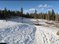
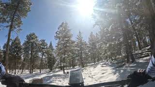
Fun easy ride in the trees, I got about 300ft of elevation in one lap on Strava. Lots of hikers and dog walkers also patrolled often by JEFFCO.

This loop is great for beginners or after an injury or if you just want a fun chill short ride. Enough to keep it interesting but not very intimidating, there are a couple of challenging spots for beginners but very manageable. Parking can be difficult on the weekends and nice bathrooms at the main trail head.

Local Trail Association
Traditionally Indigenous Territory

Recent Activity on Trail

Past Week
  • 2 rides
  • 7 miles average
6 Months
  • 20 rides
  • 7 miles avg distance
All
  • 215 rides
  • Last: Jun 18, 2026
c1c2c3c4
January
February
March
April
May
June
July
August
September
October
November
December
update trails status or condition

Shadow Pine Loop Trail Reports

statusdatedescription
May 16, 2026 @ 8:27am (America/Denver)
May 16, 2026
Jun 8, 2025 @ 8:26am
Jun 8, 2025
Great ride at elevation and was able to clock 3 laps. Some fun descents, a few things to pop some air over and a few creek crossings.
Dec 26, 2023 @ 1:58pm
Dec 26, 2023
Aug 28, 2023 @ 8:43am
Aug 28, 2023
Riding nice. A few small puddles.
Jul 20, 2023 @ 3:16pm
Jul 20, 2023
more »
Status:
on May 16, 2026
Ideal
Avg: 4.08 (5 votes)
Your vote: 0

view (1,550)
close
3D
Trail Conditions
  • Unknown
  • Snow Groomed
  • Snow Packed
  • Snow Covered
  • Snow Cover Partial
  • Freeze/thaw Cycle
  • Icy
  • Prevalent Mud
  • Wet
  • Variable
  • Ideal
  • Dry
  • Very Dry
Trail Flow (Ridden Direction)
Trailforks scans users ridelogs to determine the most popular direction each trail is ridden. A good flowing trail network will have most trails flowing in a single direction according to their intension.
The colour categories are based on what percentage of riders are riding a trail in its intended direction.
  • > 96%
  • > 90%
  • > 80%
  • > 70%
  • > 50%
  • < 50%
  • bi-directional trail
  • no data
Trail Last Ridden
Trailforks scans ridelogs to determine the last time a trail was ridden.
  • < 2 days
  • < 1 week
  • < 2 weeks
  • < 1 month
  • < 6 months
  • > 6 months
Trail Ridden Direction
The intended direction a trail should be ridden.
  • Downhill Only
  • Downhill Primary
  • Both Directions
  • Uphill Primary
  • Uphill Only
  • One Direction
Contribute Details
Colors indicate trail is missing specified detail.
  • Description
  • Photos
  • Description & Photos
  • Videos
Trail Popularity ?
Trailforks scans ridelogs to determine which trails are ridden the most in the last 9 months. Trails are compared with nearby trails in the same city region with a possible 25 colour shades. Think of this as a heatmap, more rides = more kinetic energy = warmer colors.
  • most popular
  • popular
  • less popular
  • not popular
ATV/ORV/OHV Filter
Max Vehicle Width
inches
US Cell Coverage
Legend
cell carrier legend

Radar Time
Activity Recordings
Trailforks uses anonymized public activity data. ?
Activity Recordings
Trailforks uses anonymized public activity data. ?
Personal Heatmap
Activity Types
all / none
Options
2
Date range month
Winter Trails
Warning A routing network for winter maps does not exist. Selecting trails using the winter trails layer has been disabled.
Missing Trails
Most Popular
Least Popular
Trails are colored based on popularity. The more popular a trail is, the more red. Less popular trails trend towards green.
Jump Magnitude Heatmap
Heatmap of where riders jump on trails. Zoom in to see individual jumps, click circles to view jump details.
BC Backroad Status

Service Road Atlas is a free to use, community-driven service for viewing and creating reports on the numerous back-country service roads around B.C. and Alberta.

map legend
Slope Aspect
Direction the slope faces
Flat N NE E SE S SW W NW
Trails Deemphasized
Trails are shown in grey.
disable
Only show trails with no bike usage.
Enable
Suggested Layers
Based on selected activity type

    Save the current map location and zoom level as your default home location whenever this page is loaded.

    Save
        Directions to shadow-pine-loop trailhead (39.544888, -105.322014)

        Photos

        4 more »
        20 |
        May 16, 2026 @ 7:59am
        May 16, 2026
        113 |
        May 25, 2024 @ 8:43pm
        May 25, 2024
        90 |
        Dec 28, 2018 @ 10:16pm
        Dec 28, 2018
        133 |
        Dec 28, 2018 @ 10:16pm
        Dec 28, 2018

        Videos

        2 more »
        Shadow Pine Loop (clockwise) - Flying J Ranch...
        10:31 | 75 | Jan 16, 2025 , Conifer
        Shadow Pine Loop - Flying J Ranch - Conifer -...
        0:02 | 184 | Mar 10, 2024 , Conifer

        Routes with this trail

        4 miles 389 ft 3
        A loop including the Shadow Pine trail.

        1 Review & Comments


        We hope you've been enjoying Trailforks!

        Create a FREE account to view trail comments and much more.

        • By mtbyeticoTF Pro & contributors
        • #96813 - 2,760 views

        Frequently Asked Questions About Shadow Pine Loop

        Where is Shadow Pine Loop located?
        Shadow Pine Loop is located in Flying J Ranch, Conifer, Colorado, United States. It is part of the Flying J Ranch trail network. The trailhead is located at coordinates 39.54489, -105.32201.
        How hard is Shadow Pine Loop?
        Shadow Pine Loop is rated as Green difficulty. The physical rating is Easy. The climb difficulty is rated Green.
        What is the elevation gain for Shadow Pine Loop?
        Shadow Pine Loop has 549 ft of elevation gain. The trail has 549 ft of elevation descent. The elevation ranges from 8,068 ft to 8,294 ft.
        Is Shadow Pine Loop a point to point trail?
        Shadow Pine Loop is not a point to point trail. The direction is Both Directions. The trail type is singletrack.

        Hit the Trail

        Open in App

        Get this trail on your phone instantly.
        open trail in app

        Download Trail

        Save to wishlist, Garmin & download.
        save the trail

        Find Related Routes

        Find routes and users activities that include this trail.
        find routes for this trail

        You must enter a description before submitting.