more stats
4,547 ft
Distance
108 ft
Climb
-301 ft
Descent
00:16:28
Avg time
-194 ft
Altitude change
1,214 ft
Altitude min
1,467 ft
Altitude max
1,407 ft
Altitude start
1,214 ft
Altitude end
-4.3%
Grade
-39.8%
Grade max
15.9%
Grade min
1,355 ft
Distance climb
1,991 ft
Distance down
1,102 ft
Distance flat
00:16:28
Avg time

Shearpin Details

  • Activities
    • Mountain Bike
    • E-Bike
  • Riding Area
    Blue Derby
    Derby
  • Difficulty Rating
  • Local Popularity
    20 in Mountain Biking [+]
    • 20 in E-Biking
  • Global Ranking
    #114754 in Mountain Biking [+]
    • #101332 in E-Biking
  • Trail Type
    Singletrack
  • Bike Type
    DH, AM
  • Direction
    Downhill Only[+]
    Popular Direction Shown
    • Downhill Only for E-Biking
  • Climb Difficulty
    Black Diamond
  • Physical Rating
    Hard
  • Trail Visibility
    Always easy to follow
  • Dogs Allowed
    Yes
  • eBike Allowed
  • TTFs on Trail
    Drop, Jump, Gap Jump, Rock Face, Rock Garden
  • Year Opened
    2017

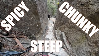
Rock features are everywhere – big off-camber rock slabs, narrow ledges perched high up beside cliffs, rock drops and more. Challenging and highly technical – a true test of both skill and nerve

Local Trail Association
Traditionally Indigenous Territory

Recent Activity on Trail

Past Week
  • 0 rides
  •  
6 Months
  • 16 rides
  • 33.5 km avg distance
All
  • 63 rides
  • Last: Jun 22, 2026
c1c2c3c4
January
February
March
April
May
June
July
August
September
October
November
December
update trails status or condition

Shearpin Trail Reports

statusdatedescription
Jun 24, 2025 @ 7:00am
Jun 24, 2025
reporter
Jun 23, 2025 @ 6:51pm
Jun 23, 2025
reporter
Apr 28, 2025 @ 2:42pm
Apr 28, 2025
reporter
Apr 16, 2025 @ 1:42pm
Apr 16, 2025
Jan 1, 2025 @ 5:31pm
Jan 1, 2025
Tree down in bottom 1/3. Requires walk around 2nd January.
more »
Status:
on Jun 24, 2025
Wet
Avg: 4.07 (8 votes)
Your vote: 0

view (657)
close
3D
Trail Conditions
  • Unknown
  • Snow Groomed
  • Snow Packed
  • Snow Covered
  • Snow Cover Partial
  • Freeze/thaw Cycle
  • Icy
  • Prevalent Mud
  • Wet
  • Variable
  • Ideal
  • Dry
  • Very Dry
Trail Flow (Ridden Direction)
Trailforks scans users ridelogs to determine the most popular direction each trail is ridden. A good flowing trail network will have most trails flowing in a single direction according to their intension.
The colour categories are based on what percentage of riders are riding a trail in its intended direction.
  • > 96%
  • > 90%
  • > 80%
  • > 70%
  • > 50%
  • < 50%
  • bi-directional trail
  • no data
Trail Last Ridden
Trailforks scans ridelogs to determine the last time a trail was ridden.
  • < 2 days
  • < 1 week
  • < 2 weeks
  • < 1 month
  • < 6 months
  • > 6 months
Trail Ridden Direction
The intended direction a trail should be ridden.
  • Downhill Only
  • Downhill Primary
  • Both Directions
  • Uphill Primary
  • Uphill Only
  • One Direction
Contribute Details
Colors indicate trail is missing specified detail.
  • Description
  • Photos
  • Description & Photos
  • Videos
Trail Popularity ?
Trailforks scans ridelogs to determine which trails are ridden the most in the last 9 months. Trails are compared with nearby trails in the same city region with a possible 25 colour shades. Think of this as a heatmap, more rides = more kinetic energy = warmer colors.
  • most popular
  • popular
  • less popular
  • not popular
ATV/ORV/OHV Filter
Max Vehicle Width
inches
US Cell Coverage
Legend
cell carrier legend

Radar Time
Activity Recordings
Trailforks uses anonymized public activity data. ?
Activity Recordings
Trailforks uses anonymized public activity data. ?
Personal Heatmap
Activity Types
all / none
Options
2
Date range month
Winter Trails
Warning A routing network for winter maps does not exist. Selecting trails using the winter trails layer has been disabled.
Missing Trails
Most Popular
Least Popular
Trails are colored based on popularity. The more popular a trail is, the more red. Less popular trails trend towards green.
Jump Magnitude Heatmap
Heatmap of where riders jump on trails. Zoom in to see individual jumps, click circles to view jump details.
BC Backroad Status

Service Road Atlas is a free to use, community-driven service for viewing and creating reports on the numerous back-country service roads around B.C. and Alberta.

map legend
Slope Aspect
Direction the slope faces
Flat N NE E SE S SW W NW
Trails Deemphasized
Trails are shown in grey.
disable
Only show trails with no bike usage.
Enable
Suggested Layers
Based on selected activity type

    Save the current map location and zoom level as your default home location whenever this page is loaded.

    Save
        Directions to shearpin trailhead (-41.166970, 147.810830)

        Photos

        2 more »
        125 |
        Feb 20, 2022 @ 12:54pm
        Feb 20, 2022
        132 |
        Feb 20, 2022 @ 12:54pm
        Feb 20, 2022

        Videos

        5 more »
        STEEP SPICY CHUNKY Trails - Kumma-Gutza...
        14:23 | 139 | Dec 27, 2024 , Derby
        Rocks that will rattle your eyeballs loose |...
        2:05 | 274 | Nov 30, 2023 , Derby
        Blue Derby MTB - The EWS Trails - Kumma-Gutza,...
        19:18 | 685 | Dec 13, 2019 , Derby
        Shearpin Upper
        11:20 | 1268 | Feb 3, 2018 , Derby

        Routes with this trail

        7 miles 912 ft 2 Shuttled
        2nd stage of the 'All Derby blacks in a day' ride
        5.0 28 miles 5,676 ft 20 Race
        The Enduro World Series is delighted to be heading back to Derby, Tasmania for round two of the 2019...
        22 miles 4,431 ft 12 Loop Race
        EWS80 Course for the 2019 Shimano Enduro Tasmania - Enduro World Series

        3 Reviews & Comments


        We hope you've been enjoying Trailforks!

        Create a FREE account to view trail comments and much more.

        • By mjjrTF Pro & contributors
        • #114805 - 2,220 views

        Frequently Asked Questions About Shearpin

        Where is Shearpin located?
        Shearpin is located in Blue Derby, Derby, Australia. It is part of the Blue Derby trail network. The trailhead is located at coordinates -41.16697, 147.81083.
        How hard is Shearpin?
        Shearpin is rated as Double Black Diamond difficulty. The physical rating is Hard. The average grade is 4.3%. The climb difficulty is rated Black Diamond.
        What is the elevation gain for Shearpin?
        Shearpin has 33 m of elevation gain. The trail has 92 m of elevation descent. The elevation ranges from 370 m to 447 m.
        Is Shearpin a point to point trail?
        Yes, Shearpin is a point to point trail. The direction is Downhill Only. The trail type is singletrack.

        Hit the Trail

        Open in App

        Get this trail on your phone instantly.
        open trail in app

        Download Trail

        Save to wishlist, Garmin & download.
        save the trail

        Find Related Routes

        Find routes and users activities that include this trail.
        find routes for this trail

        You must enter a description before submitting.