
more stats
2,103 ft
Distance
10 ft
Climb
-356 ft
Descent
00:11:37
Avg time
-346 ft
Altitude change
1,072 ft
Altitude min
1,420 ft
Altitude max
1,418 ft
Altitude start
1,073 ft
Altitude end
-16.5%
Grade
-60.7%
Grade max
11%
Grade min
253 ft
Distance climb
1,532 ft
Distance down
318 ft
Distance flat
00:11:37
Avg time

Detonate Details

  • Activities
    • Mountain Bike
    • E-Bike
  • Riding Area
    Blue Derby
    Derby
  • Difficulty Rating
  • Voted Difficulty
    Proline (3 votes)
  • Local Popularity
    40 in Mountain Biking [+]
    • 25 in E-Biking
  • Global Ranking
    #87929 in Mountain Biking [+]
    • #118172 in E-Biking
  • National Ranking
    #4,219 in Mountain Biking · Australia [+]
    • #5,712 in E-Biking
  • Trail Type
    Singletrack
  • Bike Type
    DH, AM
  • Direction
    Downhill Only[+]
    Popular Direction Shown
    • Downhill Only for E-Biking
  • Physical Rating
    Hard
  • Trail Visibility
    Always easy to follow
  • Dogs Allowed
    Yes
  • eBike Allowed
  • TTFs on Trail
    Berm, Drop, Jump, Gap Jump, Rock Face, Rock Garden

Highly technical rocky, handlebar width trail traversing a granite slab into natural flat corners. A feature is the now famous “Chute” featured in Stage 2 of the EWS 2017. Detonate was voted Trail of the Year in EWS 2017.

Tags

Local Trail Association

Traditionally Indigenous Territory

Recent Activity on Trail

Past Week
  • 0 rides
  •  
6 Months
  • 6 rides
  • 15 miles avg distance
All
  • 181 rides
  • Last: Oct 10, 2026
c1c2c3c4
January
February
March
April
May
June
July
August
September
October
November
December
Status:
on Sep 17, 2026
Dry
Avg: 4.4 (14 votes)
Your vote: 0

view (1,796)
close
      Directions to detonate trailhead (-41.164910, 147.808870)

      Photos

      29 more »
      mtb
      681 |
      Apr 1, 2019 @ 4:16am
      Apr 1, 2019
      mtb
      125 |
      Mar 4, 2019 @ 8:07pm
      Mar 4, 2019
      mtb
      209 |
      Mar 4, 2019 @ 8:07pm
      Mar 4, 2019
      mtb
      279 |
      Mar 4, 2019 @ 8:07pm
      Mar 4, 2019

      Videos

      14 more »
      youtuber Riding this Iconic Tech trail BLIND | Detonate
      mtb
      2:58 | 133 | Feb 28, 2026 , Derby
      youtuber Ultimate Guide: BLUE DERBY Mountain bike park 2026
      mtb
      10:21 | 90 | Apr 8, 2026 , Derby
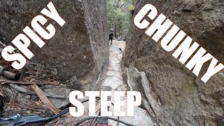
      STEEP SPICY CHUNKY Trails - Kumma-Gutza...
      mtb
      14:23 | 174 | Dec 27, 2024 , Derby
      youtuber Derby’s HARDEST Trails! | Tasmania Australia
      mtb
      11:09 | 382 | Jul 16, 2024 , Derby

      Routes with this trail

      ★ 5.0 • 28 miles • 5,676 ft • 20 • Race •
      The Enduro World Series is delighted to be heading back to Derby, Tasmania for round two of the 2019...
      16 miles • 2,444 ft • 16 • Point to Point • Race •
      23 miles • 4,717 ft • 37 • Race •
      Round 3 of the Shimano Enduro Tour and Round 2 of the 2019 EWS Asia Pacific Series
      4.6 ★★★★★
      14 Ratings
      5 ★ 71%
      4 ★ 14%
      3 ★ 14%
      2 ★
      1 ★

      3 Reviews & Comments

      dexter-mtb dexter-mtb
      Very gnarly! Def not for anyone other than extremely advanced riders, i would rank it as a pro trail. def not a double black lol
      foxfraser foxfraser
      Great tech trail, while it is shorter than some of the other black trails in the network, it packs a punch, with plenty of chunk to go around.
      freeriderayward freeriderayward
      Not for the faint hearted!! Muscle up and blast down. Join the multitudes (myself included haha) that have lost some skin and blood down the infamous "Chute". Also known as "The Big Crack", "The Big Divide", and "The Narrow Bit". And if you can successfully hit the "Lillypad Gap" a bit further up, count yourself with the pros!!

      We hope you've been enjoying Trailforks!

      Create a FREE account to view all trail reviews and much more.

      • By mjjrTF Pro & contributors
      • #114806 - 5,800 views

      Frequently Asked Questions

      ▼ Where is Detonate located?
      Detonate is located in Blue Derby, Derby, Australia. It is part of the Blue Derby trail network. The trailhead is located at coordinates -41.16491, 147.80887.
      ▼ How hard is Detonate?
      Detonate is rated as Double Black Diamond difficulty. The physical rating is Hard. The average grade is 16.5%.
      ▼ What is the elevation gain for Detonate?
      Detonate has 10 ft of elevation gain. The trail has 356 ft of elevation descent. The elevation ranges from 1,072 ft to 1,420 ft.
      ▼ Is Detonate a point to point trail?
      Yes, Detonate is a point to point trail. The direction is Downhill Only. The trail type is singletrack.
      ▼ How long is Detonate?
      Detonate is 2,103 ft long. The trail type is singletrack.
      ▼ Are dogs allowed on Detonate?
      Yes, dogs are allowed on Detonate. Please keep dogs on a leash where required and clean up after them.
      ▼ How do I access Detonate? Where is the closest parking trailhead?
      The closest parking and trailhead locations to Detonate are: View all parking locations in the area.
      ▼ How long does it take to ride Detonate?
      Based on recorded activities, it takes an average of 12 minutes to ride Detonate. The trail is 2,103 ft long. Actual times will vary based on fitness level, conditions, and pace. View recent activity logs for more details.
      ▼ How busy is Detonate?
      Detonate is a moderately popular trail. There have been 1,780 recorded activities on this trail. The trail has received 1,796 check-ins. View recent activity on this trail.

      Hit the Trail

      Open in App

      Get this trail on your phone instantly.

      open trail in app

      Download Trail

      Save to wishlist, Garmin & download.
      save the trail

      Find Related Routes

      Find routes and users activities that include this trail.
      find routes for this trail

      You must enter a description before submitting.

